Orwell, New York
| Orwell, New York | |
|---|---|
| Town | |
 Location in Oswego County and the state of New York. | |
| Coordinates: 43°33′30″N 75°57′3″W / 43.55833°N 75.95083°W | |
| Country | United States |
| State | New York |
| County | Oswego |
| Area | |
| • Total | 41.3 sq mi (107.0 km2) |
| • Land | 39.8 sq mi (103.0 km2) |
| • Water | 1.6 sq mi (4.0 km2) |
| Elevation | 1,001 ft (305 m) |
| Population (2010) | |
| • Total | 1,167 |
| Time zone | Eastern (EST) (UTC-5) |
| • Summer (DST) | EDT (UTC-4) |
| ZIP code | 13426 |
| Area code(s) | 315 |
| FIPS code | 36-55453 |
| GNIS feature ID | 0979320 |
Orwell is a town in Oswego County, New York, United States. The population was 1,167 at the 2010 census. The town was named after Orwell, Vermont.
The Town of Orwell is in the north-central part of the county.
History
The town was first settled around 1806. The Town of Orwell was created from part of the Town of Richland in 1817. In 1828, Orwell was reduced by the founding of the Town of Boylston, but more territory was obtained from Richland in 1844.
The Town of Orwell is a "dry" community.[1]
Geography
According to the United States Census Bureau, the town has a total area of 41.3 square miles (107 km2), of which, 39.8 square miles (103 km2) of it is land and 1.5 square miles (3.9 km2) of it (3.75%) is water.
Demographics
| Historical population | |||
|---|---|---|---|
| Census | Pop. | %± | |
| 1820 | 336 | — | |
| 1830 | 501 | 49.1% | |
| 1840 | 808 | 61.3% | |
| 1850 | 1,106 | 36.9% | |
| 1860 | 1,435 | 29.7% | |
| 1870 | 1,215 | −15.3% | |
| 1880 | 1,550 | 27.6% | |
| 1890 | 1,370 | −11.6% | |
| 1900 | 1,149 | −16.1% | |
| 1910 | 929 | −19.1% | |
| 1920 | 890 | −4.2% | |
| 1930 | 826 | −7.2% | |
| 1940 | 806 | −2.4% | |
| 1950 | 752 | −6.7% | |
| 1960 | 663 | −11.8% | |
| 1970 | 836 | 26.1% | |
| 1980 | 1,031 | 23.3% | |
| 1990 | 1,171 | 13.6% | |
| 2000 | 1,254 | 7.1% | |
| 2010 | 1,167 | −6.9% | |
| Est. 2014 | 1,194 | [2] | 2.3% |
As of the census[4] of 2000, there were 1,254 people, 419 households, and 300 families residing in the town. The population density was 31.5 people per square mile (12.2/km²). There were 701 housing units at an average density of 17.6 per square mile (6.8/km²). The racial makeup of the town was 98.17% White, 0.88% African American, 0.32% Native American, 0.08% Asian, and 0.56% from two or more races. Hispanic or Latino of any race were 0.48% of the population.
There were 419 households out of which 35.1% had children under the age of 18 living with them, 58.7% were married couples living together, 7.4% had a female householder with no husband present, and 28.4% were non-families. 21.2% of all households were made up of individuals and 7.2% had someone living alone who was 65 years of age or older. The average household size was 2.79 and the average family size was 3.23.
In the town the population was spread out with 28.6% under the age of 18, 7.0% from 18 to 24, 28.1% from 25 to 44, 26.5% from 45 to 64, and 9.7% who were 65 years of age or older. The median age was 36 years. For every 100 females there were 120.0 males. For every 100 females age 18 and over, there were 124.9 males.
The median income for a household in the town was $35,000, and the median income for a family was $37,500. Males had a median income of $34,000 versus $21,500 for females. The per capita income for the town was $15,256. About 16.6% of families and 21.5% of the population were below the poverty line, including 25.7% of those under age 18 and 10.4% of those age 65 or over.
Communities and locations in Orwell
- Beecherville – A hamlet in the southeast part of the town, northeast of Stillwater.
- Bennett Bridge – A location south of Pekin.
- Castor Corners – A location northwest of Orwell village.
- Chateaugay – A hamlet east of Orwell village. It was also called "Shatagee."
- Little America – A location southeast of Stillwater.
- New Scriba – A hamlet on the north town line east of Vorea.
- Orwell – The hamlet of Orwell, sometimes called "Orwell Corners," is at the junction of Routes 2 and 22.
- Salmon River Falls – A 110-foot (34 m) waterfall located within the town.
- Salmon River Reservoir – Part of the reservoir is in the southeast part of the town.
- Stillwater – A hamlet in the southeast part of the town. The Stillwater Bridge was listed on the National Register of Historic Places in 1997.[5]
- Vorea – A hamlet northeast of Orwell village near the north town line.
References
- ↑ "Oswego County Timeline". Retrieved 17 March 2012.
- ↑ "Annual Estimates of the Resident Population for Incorporated Places: April 1, 2010 to July 1, 2014". Retrieved June 4, 2015.
- ↑ "Census of Population and Housing". Census.gov. Retrieved June 4, 2015.
- ↑ "American FactFinder". United States Census Bureau. Retrieved 2008-01-31.
- ↑ National Park Service (2009-03-13). "National Register Information System". National Register of Historic Places. National Park Service.
External links
Municipalities and communities of Oswego County, New York, United States | ||
|---|---|---|
| Cities | 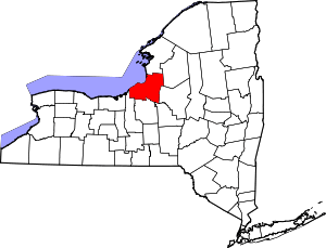 | |
| Towns | ||
| Villages | ||
| CDPs | ||
| Other hamlets |
| |
| Footnotes | ‡This populated place also has portions in an adjacent county or counties | |
Coordinates: 43°34′29″N 75°59′47″W / 43.57472°N 75.99639°W