Williamstown, New York
| Williamstown, New York | |
|---|---|
| Town | |
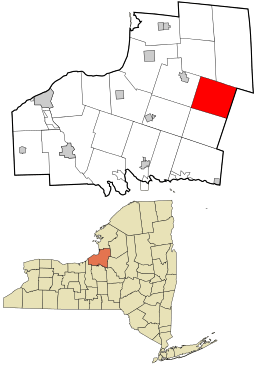 Location in Oswego County and the state of New York. | |
| Coordinates: 43°27′11″N 75°53′59″W / 43.45306°N 75.89972°W | |
| Country | United States |
| State | New York |
| County | Oswego |
| Area | |
| • Total | 39.2 sq mi (101.4 km2) |
| • Land | 38.7 sq mi (100.2 km2) |
| • Water | 0.5 sq mi (1.2 km2) |
| Elevation | 633 ft (193 m) |
| Population (2010) | |
| • Total | 1,277 |
| Time zone | Eastern (EST) (UTC-5) |
| • Summer (DST) | EDT (UTC-4) |
| ZIP code | 13493 |
| Area code(s) | 315 |
| FIPS code | 36-82073[1] |
| GNIS feature ID | 0979641[2] |
Williamstown is a town in Oswego County, New York, United States. The population was 1,277 at the 2010 census.
The Town of Williamstown is on the county's east border.
History
After the Revolutionary War Williamstown, New York did not exist until plans were made to settle west of the Hudson River. In 1791 Nicholas and John Roosevelt purchased 525,000 that covered most of Oswego, Oneida, and a small chunk of Herkimer Counties known as the Roosevelt purchase. In 1794 it was then purchased by George Scriba, which then became the Scriba Patent. Scriba then broke up most of the land that he purchased into townships and given what is now Williamstown the name Franklin, Township No.5. Ichabod Comstock was the first to settle in Franklin in 1801. Judge Henry Williams relocated to Franklin from Camden, New York in 1802 and shortly after Williams came to Franklin the people renamed the town Williamstown in Williams’s honor. Williamstown became an official town after separating from Mexico, part of Oneida county at the time on March 24, 1804. Oswego County wasn’t formed until 1816.[3]
Geography
The east town line is the border of Oneida County, New York.
According to the United States Census Bureau, the town has a total area of 39.2 square miles (102 km2), of which, 38.7 square miles (100 km2) of it is land and 0.5 square miles (1.3 km2) of it (1.20%) is water.
Demographics
| Historical population | |||
|---|---|---|---|
| Census | Pop. | %± | |
| 1820 | 652 | — | |
| 1830 | 606 | −7.1% | |
| 1840 | 842 | 38.9% | |
| 1850 | 1,121 | 33.1% | |
| 1860 | 1,144 | 2.1% | |
| 1870 | 1,833 | 60.2% | |
| 1880 | 1,820 | −0.7% | |
| 1890 | 1,215 | −33.2% | |
| 1900 | 1,023 | −15.8% | |
| 1910 | 896 | −12.4% | |
| 1920 | 767 | −14.4% | |
| 1930 | 706 | −8.0% | |
| 1940 | 710 | 0.6% | |
| 1950 | 707 | −0.4% | |
| 1960 | 739 | 4.5% | |
| 1970 | 883 | 19.5% | |
| 1980 | 1,008 | 14.2% | |
| 1990 | 1,279 | 26.9% | |
| 2000 | 1,350 | 5.6% | |
| 2010 | 1,277 | −5.4% | |
| Est. 2014 | 1,281 | [4] | 0.3% |
As of the census[1] of 2000, there were 1,350 people, 449 households, and 338 families residing in the town. The population density was 34.9 people per square mile (13.5/km²). There were 634 housing units at an average density of 16.4 per square mile (6.3/km²). The racial makeup of the town was 98.07% White, 0.37% African American, 0.15% Native American, 0.37% Asian, 0.30% from other races, and 0.74% from two or more races. Hispanic or Latino of any race were 1.19% of the population.
There were 449 households out of which 43.0% had children under the age of 18 living with them, 55.9% were married couples living together, 11.8% had a female householder with no husband present, and 24.5% were non-families. 19.8% of all households were made up of individuals and 7.3% had someone living alone who was 65 years of age or older. The average household size was 3.01 and the average family size was 3.41.
In the town the population was spread out with 34.6% under the age of 18, 9.2% from 18 to 24, 28.8% from 25 to 44, 20.0% from 45 to 64, and 7.4% who were 65 years of age or older. The median age was 31 years. For every 100 females there were 95.1 males. For every 100 females age 18 and over, there were 97.5 males.
The median income for a household in the town was $31,509, and the median income for a family was $34,688. Males had a median income of $32,566 versus $21,375 for females. The per capita income for the town was $12,599. About 13.5% of families and 14.2% of the population were below the poverty line, including 13.8% of those under age 18 and 13.9% of those age 65 or over.
Communities and locations in Williamstown
- Checkered House – A location in the western part of the town on Route 13.
- Happy Valley – A hamlet on the west town line.
- Kasoag – A hamlet in the center of the town. Kasoag was originally an old Oneida Indian trail from Oneida Castle to the Salmon River, and many relics of the Oneidas are still found in Kasoag to this day. In 1810 the first settlement of Kasoag was built by William Hamilton and the original dam he built for his saw mill still stands to this very day.[6]
- Maple Hill – A hamlet north of Williamstown village.Maple Hill, came to be in 1860. It was created by Calvert Comstock a prominent business man from Rome, New York who owned a bunch of timber and saw mills. In 1962-63 a store, a school, and a post office were constructed on Maple Hill. From 1962-1970 Comstock had more track for the Williamstown & Redfield Railroad placed in, those tracks were known in that area as the “Maple Hill Railroad.” Comstock did this to support his timber contract with Rome to the Central. Eventually all the valuable timber was used up and Maple Hill as abandoned except a few farmers in the year 1876.[7][8]
- Ricard – A hamlet in the north part of the town.
- Williamstown – The hamlet of Williamstown is in the southeast part of the town on Route 13.
- Case Wall – The Case Wall two miles north of the Town of Williamstown was built by Jonathan Case Jr. from 1838-1880. Case Wall is a famous and historical sight. Case originally built the wall to keep travelers and passerby out of his award winning apple orchards. Most of the stones for the Case Wall were either pulled from the roads of that day or plowed out of fields. Some of the amazing feats for this time are that the wall has no mortar or cement to hold it together; all the rocks were hand-picked and leveled off with only a chisel and a maul. Some of the stones on the Case Wall weigh as much as 300 pounds and in some places it is seven feet tall by five feet wide and in some areas it was wide enough to ride a horse and buggy on. Case Wall is also two miles long. Officials in Williamstown are working on getting the Case Wall on a national registry which would make it illegal for people to steal the flat stones of the wall which is common at this sight.[9][10]
References
- 1 2 "American FactFinder". United States Census Bureau. Retrieved 2008-01-31.
- ↑ "US Board on Geographic Names". United States Geological Survey. 2007-10-25. Retrieved 2008-01-31.
- ↑ Gorski, Glenna, Clevland, Roberta, Loomis, Willard, Gardner, Florance, La Duke, Anne."A Look at the Past: Williamstown,NY."Compco,Inc.,1991.Print.
- ↑ "Annual Estimates of the Resident Population for Incorporated Places: April 1, 2010 to July 1, 2014". Retrieved June 4, 2015.
- ↑ "Census of Population and Housing". Census.gov. Retrieved June 4, 2015.
- ↑ Gorski, Glenna, Cleveland, Roberta, Loomis, Willard, Gardner, Florence, La Duke, Anne. “A Look at the Past: Williamstown, NY.” Compco, Inc., 1991.Print.
- ↑ Palmer, Richard. “Maple Hill and the Williamstown & Redfield Railroad.” Rome Sentinel.
- ↑ Gorski, Glenna, Cleveland, Roberta, Loomis, Willard, Gardner, Florence, La Duke, Anne. “A Look at the Past: Williamstown, NY.” Compco, Inc., 1991.Print.
- ↑ Gorski, Glenna, Cleveland, Roberta, Loomis, Willard, Gardner, Florence, La Duke, Anne. “The Magnificent Jonathan Case Wall.” Williamstown Historical Society,2012.Print.
- ↑ Gorski, Glenna, Cleveland, Roberta, Loomis, Willard, Gardner, Florence, La Duke, Anne. “A Look at the Past: Williamstown, NY.” Compco, Inc., 1991.Print.
External links
Municipalities and communities of Oswego County, New York, United States | ||
|---|---|---|
| Cities | 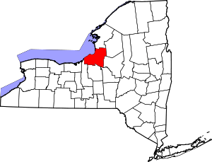 | |
| Towns | ||
| Villages | ||
| CDPs | ||
| Other hamlets |
| |
| Footnotes | ‡This populated place also has portions in an adjacent county or counties | |
Coordinates: 43°25′26″N 75°53′24″W / 43.42389°N 75.89000°W