Nafpaktos
| Nafpaktos Ναύπακτος | |
|---|---|
|
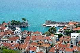
Nafpaktos; view from the fortress. | |
 Nafpaktos | |
|
Location within the regional unit  | |
| Coordinates: 38°23′N 21°49′E / 38.383°N 21.817°ECoordinates: 38°23′N 21°49′E / 38.383°N 21.817°E | |
| Country | Greece |
| Administrative region | West Greece |
| Regional unit | Aetolia-Acarnania |
| Municipality | Nafpaktia |
| • Municipal unit | 159.9 km2 (61.7 sq mi) |
| Elevation | 15 m (49 ft) |
| Population (2011)[1] | |
| • Municipal unit | 19,768 |
| • Municipal unit density | 120/km2 (320/sq mi) |
| Community[1] | |
| • Population | 31,594 (2011) |
| Time zone | EET (UTC+2) |
| • Summer (DST) | EEST (UTC+3) |
| Postal code | 303 xx |
| Area code(s) | 26340 |
| Vehicle registration | ME |
| Website | www.nafpaktos.gr |
Nafpaktos (Greek: Ναύπακτος) is a town and a former municipality in Aetolia-Acarnania, West Greece, Greece, situated on a bay on the north coast of the Gulf of Corinth, 3 km (2 mi) west of the mouth of the river Mornos.
It is named for Naupaktos (Ναύπακτος, latinized Naupactus), an important Athenian naval station in the Peloponnesian war. As a strategically crucial possession controlling access to the Gulf of Corinth, Naupactus changed hands many times during the Crusades and the Ottoman–Venetian Wars. It was under Venetian control in the 15th century, and came to be known by the Venetian form of its name, Lepanto. It fell to the Ottoman Empire in 1499 and was used as naval station by the Ottoman Navy in the 16th century, being the site of the decisively victory by the Holy League in the Battle of Lepanto in 1571. Excepting a brief period of Venetian control in 1687–1699, Lepanto remained under Ottoman control until Greek independence in 1829.
The modern municipality was incorporated in 1946, but merged into the larger Nafpaktia municipality in the 2010 reform. Nafpaktos is now both the name of a municipal unit within Nafpaktia and of the town proper within the Nafpaktos unit.[2] The municipal district has an area of 159,947 km2, with a population close to 20,000 as of 2011.[3]
The town is 9 km (6 mi) northeast of Antirrio, 18 km (11 mi) northeast of Patras, 35 km (22 mi) east of Missolonghi and 45 km (28 mi) southeast of Agrinio. The Greek National Road 48/E65 (Antirrio - Nafpaktos - Delphi - Livadeia) passes north of the town. It is the second largest town of Aetolia-Acarnania, after Agrinio.
Name
The ancient name Naupaktos (Ναύπακτος) means "boatyard" (from ναύς naus "ship" and πήγ- pêg- "to fix, fasten"). It was later Latinized as Naupactus. By the late medieval period, the local name had been corrupted to Nepahtos (Νέπαχτος), Epaktos or Epahtos (Έπακτος, Έπαχτος). By the "Franks" (Latins) it was called Neopant, Nepant or Lepant. French sources of the 14th century give Nepant or Neopant; Venetian sources have Nepanto or Lepanto.[4]
The name was adapted in Ottoman Turkish from Greek Νέπαχτος as Aynabahti or İnebahtı.[5]
The ancient name was revived in modern Greece in the 19th century.
History
Antiquity
In Greek legend, Naupactus is the place where the Heraclidae built a fleet to invade the Peloponnese.
In historical times it belonged to the Ozolian Locrians; but about 455 BC, in spite of a partial resettlement with Locrians of Opus, it fell to the Athenians, who peopled it with Messenian refugees and made it their chief naval station in western Greece during the Peloponnesian war. Two major battles were fought here. In 404 it was restored to the Locrians, who subsequently lost it to the Achaeans, but recovered it.
Philip II of Macedon gave Naupactus to the Aetolians, who held it till 191 BC, when after an obstinate siege it was surrendered to the Romans. It was still flourishing about 170.
The Roman playwright Plautus mentions Naupactus in his comedy Miles Gloriosus as the destination of an Athenian master (Pleusicles) who is on a diplomatic mission to the city.
In 551/2, during the reign of Justinian I, the city was destroyed by an earthquake.[6]
Medieval and early modern history
The town and its hinterland were hit by an epidemic coming from Italy in 747/8 and almost deserted.[6] From the late 9th century, probably the 880s, it was capital of the Byzantine thema of Nicopolis. At the same time, its bishopric was elevated to a metropolis. During the 9th–10th centuries, the town was an important harbour for the Byzantine navy and a strategic point for communication with the Byzantine possessions in southern Italy.[6][7]
A rebellion of the local populace, which led to the death of the local strategos George, is recorded during the early reign of Constantine VIII (r. 1025–28).[8] In 1040, the town did not take part in the uprising of Peter Delyan, and although attacked by the rebel army, alone among the towns of the theme of Nicopolis, it resisted successfully.[8] The history of the town over the next two centuries is obscure; during the visit of Benjamin of Tudela in 1165, there was a Jewish community of about 100 in the town.[8]
Following the dissolution of the Byzantine Empire after the Fourth Crusade, it became part of the Despotate of Epirus.[8][9] Under its metropolitan, John Apokaukos, the see of Naupactus gained in importance and headed the local synod for the southern half of the Epirote domains.[10] In 1294, the town was ceded to Philip I, Prince of Taranto as part of the dowry of Thamar Angelina Komnene. The ruler of Thessaly, Constantine Doukas, attacked Epirus in the next year and captured Naupactus, but in 1296 handed most of his conquests back to the Angevins, and Naupactus became a major Angevin base on the Greek mainland.[11] In 1304 or 1305, the Epirotes recovered Naupactus during a war with the Angevins, but handed it back when peace was concluded in 1306.[12]
In 1361 the town was captured by the Catalans of the Duchy of Athens.[8] In 1376 or 1377 it fell to John Bua Spata, an Albanian vassal of Epirus. It was briefly occupied Knights Hospitaller in 1378, and, now wedged between the expanding lands of the Count of Cephalonia Carlo I Tocco and the Ottoman possessions, sold to the Republic of Venice by Paul Spata in 1407.[13]
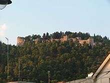
After 1449, the town was an isolated Venetian exclave in Ottoman territory, as the Ottomans completed their conquest of the rest of Epirus and Aetolia-Acarnania.[14] The town was important to Venice, as it secured their trade through the Corinthian Gulf, and the Republic took care to erect strong fortifications to secure its possession.[8] In the end, the fortress fell to the Ottomans in 1499, during the Second Ottoman–Venetian War.[8]
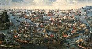
Under the Ottomans, Naupactus was known as Aynabahtı, İnebahtı and was the seat of an Ottoman province. The mouth of the Gulf of Lepanto was the scene of the great sea battle in which the naval power of the Ottoman Empire was nearly completely destroyed by the united Papal, Spanish, Habsburg and Venetian forces (Battle of Lepanto, October 7, 1571). In 1687 it was recaptured by the Venetians, but was again restored to the Ottomans in 1699, by the Treaty of Karlowitz.
Modern history
Nafpaktos became part of independent Greece in March 1829. It was incorporated as a commune in 1912 and as an independent municipality in 1946. In the 1997 reform, Nafpaktos municipality was enlarged by the incorporation of 13 communes.[15] In the 2010 reform, Nafpaktos municipality was merged with five other municipalities to form Nafpaktia municipality, and the town of Nafpaktos proper is now a communal district within the Nafpaktos municipal district of Nafpaktia municipality.
Naupactus suffered damage from the 2007 Greek forest fires.
Ecclesiastical history
The metropolitan see of Naupactus depended on the pope of Rome until 733, when Leo III the Isaurian annexed it to the Patriarchate of Constantinople.[16]
Under Frankish rule, there were about 20 archbishops in the 14-15th centuries. The city remains a titular see of the Roman Catholic church.[16]
The see was attached to the Church of Greece after the Greek War of Independence. It was suppressed in 1900, replaced by the see of Acarnania and Naupactia, whose seat is at Missolonghi.[16]
Residents

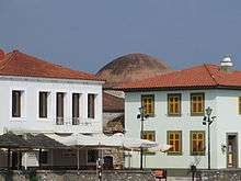
Today the population is about 19,768 people according to the 2011 census. Residential homes align with the Gulf of Corinth over a length of about 3 km (2 mi) and a width of about 1 km (0.6 mi). The port divides the beachfront in two parts. The Western part is called Psani, while the Eastern part Gribovo. Naupactus sits on a shoulder of a mountain range on the north while farmlands dominate the western part. It used to be on the GR-48/E65 linking Antirrio and Amfissa; now it is bypassed to the north at the elevation of 150 to 200 m (492 to 656 ft) above sea level. The bypass has contributed significantly in lowering the number of heavy trucks passing through the narrow streets of the town.
Landmarks
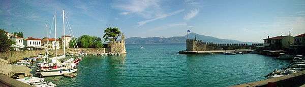
- The port and castle provide the main attraction for the town. Shops, cafes and bars dot the immediate area, while a cafe is also located within the castle walls
- The port also includes monuments commemorating the Battle of Lepanto (1571), and there is also a statue of the Cervantes by the Mallorcan artist Jaume Mir.
- A small water park is located just past the western portion of the beach near Psani
- Nafpaktos is also home to a local museum
- The Fethiye Mosque, the city's largest Ottoman-era mosque
Subdivisions
The municipal unit Nafpaktos is subdivided into the following communities (constituent villages in brackets):
- Afroxylia (Ano Afroxylia, Kato Afroxylia)
- Dafni (Dafni, Kato Dafni)
- Lygias
- Mamoulada (Kato Mamoulada, Mamoulada)
- Nafpaktos
- Neokastro (Neokastro, Paliampela)
- Palaiochoraki (Palaiochoraki, Mikro Palaiochoraki)
- Pitsinaiika (Pitsinaiika, Kastraki, Sykia)
- Riganio (Riganio, Diasello, Poros)
- Skala
- Velvina
- Vlachomandra (Vlachomandra, Gefyra Bania, Sfikaaika)
- Vomvokou (Vomvokou, Agios Vasileios, Lefka Vomvokous, Marmara)
- Xiropigado
Nearest places
- Antirrio (west)
- Katafygio (Katafigio): One of the traditional villages in Orini Nafpaktia (mountainous Nafpaktia).
- Ano chora (north): One of the traditional villages of Orini Nafpaktia
- Kentriki (north): One of the traditional villages of Orini Nafpaktia
- Aspria (north): One of the traditional villages of Orini Nafpaktia
- Chomori: One of the traditional villages of Orini Nafpaktia
- Elatovrisi or Elatou: One of the traditional villages of Orini Nafpaktia with famous natural spring water.
- Skala: Village found in the hills minutes from the town centre; overlooks the town itself
- Skaloma: beaches
- Hiliadou: Part of the strip of beachside villages outside of Nafpaktos (Hiliadou-Monastiraki-Skaloma); sandy beach makes it a popular destination for residents of Nafpaktos and tourists
- Klepa: One of the villages in Orini Nafpaktia
- Platanos
Historical population
| Year | Town population | Municipality population |
|---|---|---|
| 1981 | 9,012 | - |
| 1991 | 10,854 | 15,045 |
| 2001 | 12,924 | 18,231 |
| 2011 | 19,768 | 31,594 |
Media
Television
- Lepanto TV
Notable people
- Agelaus (3rd century BC), politician
- John Apokaukos (died 1233), Metropolitan of Naupactus from 1200 to 1232
- Georgios Athanasiadis-Novas (1893–1987), lawyer, politician and former Prime Minister of Greece
- Hierotheos (Vlachos) (born 1945), Metropolitan of Nafpaktos and Agios Vlasios
Gallery
-

View from the fortress
-

A square
-

View from the port towards the fortress
-

Statue of Miguel de Cervantes at the port (he took part at the Battle of Lepanto)
-

View of the old harbour
-

Botsaris tower museum
-
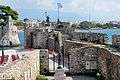
Fortifications of the port
-

Fortifications along the sea wall
Twin cities
Sports teams

See also
References
- 1 2 "Απογραφή Πληθυσμού - Κατοικιών 2011. ΜΟΝΙΜΟΣ Πληθυσμός" (in Greek). Hellenic Statistical Authority.
- ↑ Kallikratis law Greece Ministry of Interior (Greek)
- ↑ "Population & housing census 2001 (incl. area and average elevation)" (PDF) (in Greek). National Statistical Service of Greece.
- ↑ Studi bizantini, Volume 2, Istituto romane editoriale, 1927, p. 307. Abraham bar Hiyya Savasorda, La obra Forma de la tierra (1956), p 48.
- ↑ Molto importanti le forme turche, le quali si confermano magnificamente il Νέπαχτος greco." Abraham bar Hiyya Savasorda, La obra Forma de la tierra (1956), p 48
- 1 2 3 Veikou, Myrto (2012). Byzantine Epirus: A Topography of Transformation. Settlements of the Seventh-Twelfth Centuries in Southern Epirus and Aetoloacarnania, Greece. BRILL. pp. 466–468. ISBN 9004221514.
- ↑ Nesbitt, John W.; Oikonomides, Nicolas, eds. (1994). Catalogue of Byzantine Seals at Dumbarton Oaks and in the Fogg Museum of Art, Volume 2: South of the Balkans, the Islands, South of Asia Minor. Washington, DC: Dumbarton Oaks Research Library and Collection. pp. 9–10, 18. ISBN 0-88402-226-9.
- 1 2 3 4 5 6 7 Gregory, T. E. (1991). "Naupaktos". In Kazhdan, Alexander. The Oxford Dictionary of Byzantium. Oxford University Press. pp. 1442–1443. ISBN 978-0-19-504652-6.
- ↑ Fine, John Van Antwerp (1994). The Late Medieval Balkans: A Critical Survey from the Late Twelfth Century to the Ottoman Conquest. University of Michigan Press. p. 65. ISBN 978-0-472-08260-5.
- ↑ Fine, John Van Antwerp (1994). The Late Medieval Balkans: A Critical Survey from the Late Twelfth Century to the Ottoman Conquest. University of Michigan Press. p. 115. ISBN 978-0-472-08260-5.
- ↑ Fine, John Van Antwerp (1994). The Late Medieval Balkans: A Critical Survey from the Late Twelfth Century to the Ottoman Conquest. University of Michigan Press. pp. 236–237. ISBN 978-0-472-08260-5.
- ↑ Fine, John Van Antwerp (1994). The Late Medieval Balkans: A Critical Survey from the Late Twelfth Century to the Ottoman Conquest. University of Michigan Press. pp. 239–240. ISBN 978-0-472-08260-5.
- ↑ Fine, John Van Antwerp (1994). The Late Medieval Balkans: A Critical Survey from the Late Twelfth Century to the Ottoman Conquest. University of Michigan Press. pp. 352, 356, 401. ISBN 978-0-472-08260-5.
- ↑ Fine, John Van Antwerp (1994). The Late Medieval Balkans: A Critical Survey from the Late Twelfth Century to the Ottoman Conquest. University of Michigan Press. p. 544. ISBN 978-0-472-08260-5.
- ↑ Κεντρική Ένωση ∆ήµων και Κοινοτήτων Ελλάδας (ΚΕ∆ΚΕ), Ελληνική Εταιρία Τοπικής Ανάπτυξης και Αυτοδιοίκησης (ΕΕΤΑΑ) (Hrsg.): Λεξικό ∆ιοικητικών Μεταβολών των ∆ήµων και Κοινοτήτων (1912–2001). 2 (Τόμος Β, λ–ω), Athens 2002, p. 185.
- 1 2 3
 Herbermann, Charles, ed. (1913). "Lepanto". Catholic Encyclopedia. New York: Robert Appleton Company.
Sources
-
 This article incorporates text from a publication now in the public domain: Chisholm, Hugh, ed. (1911). "article name needed". Encyclopædia Britannica (11th ed.). Cambridge University Press.
External links
| Wikimedia Commons has media related to Nafpaktos. |
 |
Thermo | Pyllini | | |
| Makryneia, Chalkeia |
|
Efpalio | ||
| ||||
| | ||||
| Antirrio | Gulf of Corinth |