Ozawkie Township, Jefferson County, Kansas
| Ozawkie Township | |
|---|---|
| Township | |
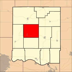 Location in Jefferson County | |
| Coordinates: 39°15′35″N 95°25′51″W / 39.25972°N 95.43083°WCoordinates: 39°15′35″N 95°25′51″W / 39.25972°N 95.43083°W | |
| Country | United States |
| State | Kansas |
| County | Jefferson |
| Area | |
| • Total | 42.78 sq mi (110.79 km2) |
| • Land | 37.33 sq mi (96.68 km2) |
| • Water | 5.45 sq mi (14.11 km2) 12.74% |
| Elevation | 1,020 ft (311 m) |
| Population (2000) | |
| • Total | 1,408 |
| • Density | 37.7/sq mi (14.6/km2) |
| GNIS feature ID | 0478336 |
Ozawkie Township is a township in Jefferson County, Kansas, USA. As of the 2000 census, its population was 1,408.
Geography
Ozawkie Township covers an area of 42.78 square miles (110.79 square kilometers); of this, 5.45 square miles (14.11 square kilometers) or 12.74 percent is water. The streams of Bowies Branch, Duck Creek, Fishpond Creek and French Creek run through this township.
Cities and towns
Unincorporated towns
- Indian Ridge
- Lake Shore
(This list is based on USGS data and may include former settlements.)
Adjacent townships
- Jefferson Township (northeast)
- Oskaloosa Township (east)
- Fairview Township (south)
- Rock Creek Township (west)
- Delaware Township (northwest)
Cemeteries
The township contains one cemetery, Fairview.
Major highways
- K-4
- K-92
References
External links
Municipalities and communities of Jefferson County, Kansas, United States | ||
|---|---|---|
| Cities | 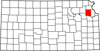 | |
| CDP | ||
| Unincorporated communities | ||
| Townships | ||
This article is issued from Wikipedia - version of the 11/11/2013. The text is available under the Creative Commons Attribution/Share Alike but additional terms may apply for the media files.