Palauig
| Palauig | |||
|---|---|---|---|
| Municipality | |||
|
Magalawa Island | |||
| |||
| Nickname(s): Home of the High Peak | |||
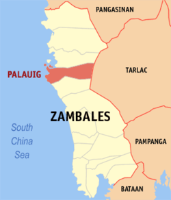 Map of Zambales showing the location of Palauig | |||
.svg.png) Palauig Location within the Philippines | |||
| Coordinates: 15°26′N 120°03′E / 15.433°N 120.050°ECoordinates: 15°26′N 120°03′E / 15.433°N 120.050°E | |||
| Country |
| ||
| Region | Central Luzon (Region III) | ||
| Province | Zambales | ||
| District | 2nd district of Zambales | ||
| Founded | 1870 | ||
| Barangays | 19 | ||
| Government[1] | |||
| • Mayor | Generoso F. Amog | ||
| Area[2] | |||
| • Total | 310.00 km2 (119.69 sq mi) | ||
| Population (2010)[3] | |||
| • Total | 33,286 | ||
| • Density | 110/km2 (280/sq mi) | ||
| Time zone | PST (UTC+8) | ||
| ZIP code | 2210 | ||
| Dialing code | 47 | ||
| Income class | 3rd class | ||
| Website |
www | ||


Palauig is a third class municipality in the province of Zambales, Philippines. According to the 2010 census, it has a population of 33,286 people.[3]
The municipality of Palauig is the nearest mainland to the Philippine-claimed EEZ Panatag Shoal, or Scarborough Shoal, and by virtue of proximity, the latter is a designated part of the municipality.
At present, Palauig is headed by Mayor Generoso F. Amog, with the Municipal Council called Sangguniang Bayan with 8 members, particularly 7 regular Councilors and the Association of Barangay Captains (ABC) President Elenita Reyes del Fierro.
Barangays
Palauig is politically subdivided into 19 barangays.[2]
- Alwa
- Bato
- Bulawen
- Cauyan
- East Poblacion
- Garreta
- Libaba
- Liozon
- Lipay
- Locloc
- Macarang
- Magalawa
- Pangolingan
- Salaza
- San Juan
- Santo Niño
- Santo Tomas
- San Vicente
- West Poblacion
Demographics
| Population census of Palauig | ||
|---|---|---|
| Year | Pop. | ±% p.a. |
| 1990 | 21,577 | — |
| 1995 | 26,794 | +4.14% |
| 2000 | 29,983 | +2.44% |
| 2007 | 30,747 | +0.35% |
| 2010 | 33,286 | +2.93% |
| Source: National Statistics Office[3][4] | ||
Language
Most of the local populations in the town proper, known locally as 'Poblacion' speak Sambal followed by Ilocano and Tagalog. But most of the present generation are speaking and more fluent in using the Filipino (Tagalog) the country's national language. The barangays of Alwa, Bato, Salaza, San Vicente and Pangolingan were known to be a majority Ilocano speakers except the rest of the barangays were majority of sambal speakers with minority of Tagalog to most of the barangays.
Tourism
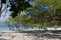
Palauig is home to the mountain climbing resort of Mount Tapulao. Because of cold climate on its summit similar to Baguio City, it has become an attraction to many local and foreign mountaineering groups and tourists. The Municipal Tourism Authority of the Palauig Municipal Government also promotes the Magalawa Island Resort and Famous Beach Resorts along the coastal Barangay of Locloc.
Due to the municipal government's aggressive tourism campaign, local and foreign tourist arrivals in the municipality is on the rise and bringing Palauig as another Tourist destination in Zambales Province.
Special Administrative Zone
- Panatag Shoal (Scarborough Shoal)
- Palauig Point (Parola)(Lighthouse)
References
- ↑ "Municipalities". Quezon City, Philippines: Department of the Interior and Local Government. Retrieved 25 March 2013.
- 1 2 "Province: Zambales". PSGC Interactive. Makati City, Philippines: National Statistical Coordination Board. Retrieved 26 March 2013.
- 1 2 3 "Total Population by Province, City, Municipality and Barangay: as of May 1, 2010" (PDF). 2010 Census of Population and Housing. National Statistics Office. Retrieved 26 March 2013.
- ↑ "Province of Zambales". Municipality Population Data. LWUA Research Division. Retrieved 16 August 2013.
External links
| Wikimedia Commons has media related to Palauig, Zambales. |
 |
Masinloc | Mayantoc, Tarlac | | |
| South China Sea | |
San Jose, Tarlac | ||
| ||||
| | ||||
| Iba |
Iba (capital) | |
| Municipalities | |
| Highly urbanized city |
|
| Barangays | |