San Marcelino
| San Marcelino | ||
|---|---|---|
| Municipality | ||
|
New San Marcelino Town Hall | ||
| ||
| Nickname(s): "Singkamas Capital of the Philippines" | ||
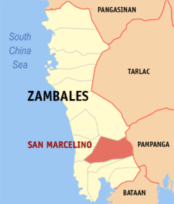 Map of Zambales showing the location of San Marcelino. | ||
.svg.png) San Marcelino Location within the Philippines | ||
| Coordinates: 14°58′N 120°09′E / 14.967°N 120.150°ECoordinates: 14°58′N 120°09′E / 14.967°N 120.150°E | ||
| Country |
| |
| Region | Central Luzon (Region III) | |
| Province | Zambales | |
| District | 1st district | |
| Barangays | 18 | |
| Government[1] | ||
| • Mayor | Elvis R. Soria | |
| • Vice Mayor | Geraldo Dalupang | |
| Area[2] | ||
| • Total | 416.86 km2 (160.95 sq mi) | |
| Population (2010)[3] | ||
| • Total | 31,879 | |
| • Density | 76/km2 (200/sq mi) | |
| Time zone | PST (UTC+8) | |
| ZIP code | 2207 | |
| Dialing code | 47 | |
| Income class | 1st class | |


San Marcelino (Ilocano: Ili ti San Marcelino; Tagalog: Bayan ng San Marcelino) is a first class municipality in the province of Zambales, Philippines. According to the 2010 census, it has a population of 31,879 people.[3]
The municipality is home to Mapanuepe Lake that formed after the 1991 eruption of Mount Pinatubo.
Etymology
The town got its name after the first Capitan Municipal whose name was Marcelino. The people of this municipality during that time were fond of Saints, so they added "San" to the name Marcelino, thus making it San Marcelino. The first election was held on January 14, 1906 and Matias Apostol was the first elected President. San Marcelino was Christianized after the arrival of Father Guillermo and after his departure, the people rightfully chose San Guillermo as their town's patron saint.
Barangays
San Marcelino is politically subdivided into 18 barangays.[2]
- Aglao
- Buhawen
- Burgos (Pob.)
- Central (Pob.)
- Consuelo Norte
- Consuelo Sur (Pob.)
- La Paz (Pob.)
- Laoag
- Linasin
- Linusungan
- Lucero (Pob.)
- Nagbunga
- Rabanes
- Rizal (Pob.)
- San Guillermo (Pob.)
- San Isidro (Pob.)
- San Rafael
- Santa Fe
History
Early Activities
The area that is now known as San Marcelino was originally owned by Sambal-speaking peoples, but overtime was purchased and entirely owned by Ilocano-speaking peoples.[4]
Marcelinian civilization, according to old Municipal documents, started at the peak of the beautiful Vega Hill in the heart of an idyllic and luxuriant Zambales jungle during the pre-Hispanic settlers from the Ilocos Region led by the old Corpuses, Udans, Ragadios, Raguinis, Rabanes and Fabunans. With courage, hard work and perseverance, these Marcelinian forefathers harnessed the untouched wilderness of Vegal Hill and its immediate surroundings and slowly converted the area into a pulsating and vibrant community nurtured by the abundant natural yield of what was once an untamed wildlife.[5]
Vega Hill reportedly measured 440.94 square kilometers. It used to be one of the three communities that comprised a town. The two others were what are now known as Castillejos and San Antonio. Castillejos was reportedly the hub of leadership because when the Ilocanos arrived in the area, the Tagalog-speaking native residents where already organized.
Naturally adventurous and united by their common struggles, the Ilocano settlers eventually left Vega Hill and stayed in Magaring, a place now known as Barangay Linasin. This area was, and still is, part of the town. Eventually, the Ilocanos decided to settle at the Poblacion. However, they refused to be integrated into the communities of the local residents. They lived according to their own tradition. They were governed by their obedience to their community elders.
When the Spaniards came, a kind-hearted Spanish friar, Father Guillermo, stayed at the Poblacion with the Marcelinian forefathers. In the succeeding years, more Spanish friars came, strengthening the stronghold of Christianity among the Ilocano settlers. The need for formalizing a political/administrative structure of the town also became evident as the population increased and the socio-economic life of the town became complex. Consequently, a government structure was set up under the leadership of the friars whose power, at this point in time, had become entrenched, anchored on religion. The friars appointed local or district leaders, a cabeza de barangay for every barangay among which were Consuelo, Nagbunga and Sinnerrekan (now known as Linusungan). The number of barangays has expanded to 18 since then.
In the settlers' barangay of barrio, a middle-aged Teniente del Barrio, Marcelino Ora, was appointed. It was after him that the town was eventually named, long after he was gone. "San" was arbitrarily added to the name due to the people's religiosity. Domingo Magsaysay and Antonio Rolls later succeeded him.
When the barangay needed to choose a patron saint, the leaders chose the priest who Christianized the town, Father Guillermo. Ath the time the priest had already left San Marcelino, Like Marcelino Ora, the title of Saint was apparently just attachéd to his name.
It was after Marcelino Ora that the town was eventually named.
In 1843, the Marcelinians filed a petition for San Marcelino's elevation to a being a Pueblo through the Teniente Primero, Antonio Ladrido Juliano. In 1846, the petition was approved.
The elation over the appointment of a local leader did not last long. The Marcelinian elders became discontented over the fact that their appointed leaders turned out to be just nominal leaders. The friars still made the decision in relation to important matters. In addition, the friars reportedly became shockingly abusive.
In anger, many of the leaders and pockets of townspeople joined the insurrectos - rebel groups. In the forefront where Jorge Udan, Francisco Corpus and Alipio Corpus. Relenting to the demands of majority of the people, the friars later agreed to give the leaders bigger participation in running their respective districts.
On March 10, 1852 San Marcelino held its first municipal election for a Teniente Absoluto. At this point, historical records became confusing. The next account has dated January 14, 1906 when a Matias Apostol was reportedly installed as the First Elected President of San Marcelino. From then on, the progressive development of San Marcelino continued under duly elected leaders.
American period
From late 1900 to March 1902, 25th Infantry Regiment, operated in the Zambales, including San Marcelino, during the Philippine-American War, with elements in San Marcelino in December 1900 and March 1902.[6] During this period, the regiment conducted policing and judiciary functions, such as the prosecution of Elias Agpalo.[7]
In 1904, due to Act Number 945 of the Philippine Commission, San Marcelino's municipal oversight was extended to neighboring Castillejos and San Antonio.[8] That same year, Ilokano was the primary language spoken in San Marcelino, with Tagalog being a secondary language;[4] of the Negrito who lived in Zambales all lived in the jurisdictions of San Marcelino or Botolan.[9] In 1905, in a report produced by the War Department, the area around San Marcelino were used to cultivate rice, and the people were Ilocano.[10]
Demographics
| Population census of San Marcelino | ||
|---|---|---|
| Year | Pop. | ±% p.a. |
| 1990 | 36,598 | — |
| 1995 | 24,425 | −7.30% |
| 2000 | 25,440 | +0.88% |
| 2007 | 29,052 | +1.85% |
| 2010 | 31,879 | +3.44% |
| Source: National Statistics Office[3][11] | ||
San Marcelino Airfield
San Marcelino Airfield was built before the war by the Americans. On the morning of 29 January 1945 nearly 35,000 U.S. troops landed just north-west of San Marcelino. Elements of the US 38th Division immediately dashed inland to take the airstrip, but found that Filipino soldiers of the 3rd, 31st, 32nd, 33rd, 35th and 36th Infantry Division of the Philippine Commonwealth Army and the recognized guerrillas under the command of Capt. Ramon Magsaysay, later President of the Republic of the Philippines, had secured the field three days earlier.[12]
After the liberation by combined Filipino-American troops in Zambales in 1945, it was developed into a Fifth Air Force command facility as well as an operational airfield. With the end of the war, the airfield was closed and is now part of the town of San Marcelino.[13]
Ramon Magsaysay Technological University
Ramon Magsaysay Technological University, formerly known as Western Luzon Agricultural College or WLAC is a government funded higher education institution in Zambales established in 1910 and converted into a state university in 1998 thus changing its name from Western Luzon Agricultural College to Ramon Magsaysay Technological University under the University system. The main campus of the university is located at the Municipality of Iba, Province of Zambales. The university is named after the province's greatest son and former President of the Republic of the Philippines, President Ramon Magsaysay. It also has satellite campuses in the municipalities of Sta. Cruz, Candelaria, Masinloc, Botolan, San Marcelino and Castillejos - all in the province of Zambales. The university also offers nursing courses at the Mondriaan Aura College in SBMA under a consortium program.
RMTU is one of the fastest growing state universities in the country. This was proven when the Department of Budget and Management in 2007 classified RMTU as a Level III-A university, thus leveling with established universities in Metro Manila like the University of the Philippines and the Polytechnic University of the Philippines.
On February 12, 1998, President Fidel Ramos signed Republic Act 8498 authored by Zambales 2nd District Representative Antonio Magsaysay Diaz. The law integrated the Ramon Magsaysay Polytechnic College in Iba, the Western Luzon Agricultural College in San Marcelino ( with campus in the Municipality of Botolan), and the Candelaria School of Fisheries in Candelaria into a university system known as Ramon Magsaysay Technological University. A three- year transition period transpired before the formal operation of the university in 2001. In the same year, Dr. Feliciano S. Rosete was invested as the first president of the university.
Festivals
- Singkamas Festival
- Mango Festival
References
- ↑ "Municipalities". Quezon City, Philippines: Department of the Interior and Local Government. Retrieved 19 March 2013.
- 1 2 "Province: Zambales". PSGC Interactive. Makati City, Philippines: National Statistical Coordination Board. Retrieved 19 March 2013.
- 1 2 3 "Total Population by Province, City, Municipality and Barangay: as of May 1, 2010" (PDF). 2010 Census of Population and Housing. National Statistics Office. Retrieved 19 March 2013.
- 1 2 Reed, William Allan (1904). Negritos of Zambales, Volume 2, Parts 1-3. Bureau of Public Printing. p. 218. Retrieved 7 September 2014.
- ↑ Tina (29 June 2006). "Facts & Figures". http://www.classof1974sws.org/. wordpress.org. Retrieved 5 September 2014. External link in
|website=(help) - ↑ Nankivell, John Henry (1927). Buffalo Soldier Regiment: History of the Twenty-fifth United States Infantry, 1869-1926. U of Nebraska Press. pp. 94–97. ISBN 9780803283794. Retrieved 7 September 2014.
- ↑ Barry, Brigadier General Thomas H. (6 June 1901). "General Orders, No. 114". Hearings Before the Committee on the Philippines of the United States Senate in Relation to Affairs in the Philippine Islands [January 31-June 28, 1902], Volume 2. U.S. Government Printing Office. pp. 1174–1175. Retrieved 7 September 2014.
- ↑ Root, Elihu (1905). Elihu Root collection of United States documents relating to the Philippine Islands, Volume 123. Government Printing Office. p. 100. Retrieved 6 September 2014.
- ↑ Reed, William Allan (1904). Negritos of Zambales, Volume 2, Parts 1-3. Bureau of Public Printing. p. 30. Retrieved 7 September 2014.
- ↑ Annual Reports of the War Department, Volume 12. U.S. Government Printing Office. 1905. p. 341. Retrieved 7 September 2014.
- ↑ "Province of Zambales". Municipality Population Data. LWUA Research Division. Retrieved 16 August 2013.
- ↑ Smith, Robert Ross (29 May 2011). Triumph in the Philippines (PDF). Washington, D.C.: United States Army. pp. 67–68. ISBN 978-1-4102-2495-8. Check date values in:
|year= / |date= mismatch(help) - ↑ Cate, James Lea; Craven, Wesley Frank, eds. (1948). The Army Air Forces in World War II. DIANE Publishing. p. 424. ISBN 9781428915909. Retrieved 20 March 2013.
External links
| Wikimedia Commons has media related to San Marcelino, Zambales. |
- Philippine Standard Geographic Code
- Philippine Census Information
- "US Amphibious Assault on Zambales: 29 January 1945" (PDF). The Reports of General MacArthur. United States Army. 1995.
 |
Botolan | Porac, Pampanga | | |
| San Felipe San Narciso |
|
|||
| ||||
| | ||||
| San Antonio | Castillejos / Subic | Floridablanca, Pampanga |
Iba (capital) | |
| Municipalities | |
| Highly urbanized city |
|
| Barangays | |