Par River, Cornwall
Coordinates: 50°20′35″N 4°42′11″W / 50.343°N 4.703°W
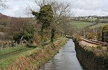
The Par River (Cornish: Dowr Gwernan, meaning alder tree river), also known as the Luxulyan River is a river draining the area north of St Blazey in Cornwall, in the United Kingdom.
The Par River rises on Criggan Moor, with tributaries rising near Crift, Bokiddick Downs, and the villages of Lockengate, Lanivet and Tregullon near Bodmin. It flow southwards via Bokiddick, Bodwen, and through the Luxulyan Valley, to flow into St Austell Bay at Par.[1]
Until the 16th century the valley below St Blazey contained an estuary and the crossing at St Blazey was the lowest crossing point on the river.[2] Ponts Mill was once a port, up-river of St Blazey, and as late as 1720, 80 ton sea going vessels could reach the port.[3]
References
- ↑ Smith, John R (1988). "The Luxulyan Valley" (PDF). Cornwall Archaeological Society. Retrieved 31 March 2015.
- ↑ "Cornwall Industrial Settlements Initiative ST BLAZEY (with St Blazey Gate and West Par)" (PDF). Historic Environment Service, Cornwall County Council. June 1999. Retrieved 4 February 2012.
- ↑ Bristow, Colin M (1996). Cornwall's Geology and Scenery. An Introduction. St Austell: Cornish Hillside Publications. p. 137. ISBN 1 900147 01 7.
Cornwall Portal | |
| Unitary authorities | |
| Major settlements |
|
| Rivers | |
| Topics | |