Parrakie, South Australia
| Parrakie South Australia | |||||||||||||
|---|---|---|---|---|---|---|---|---|---|---|---|---|---|
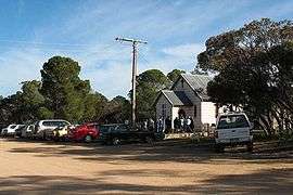 Parrakie Lutheran Church on Price Street | |||||||||||||
 Parrakie | |||||||||||||
| Coordinates | 35°22′S 140°15′E / 35.367°S 140.250°ECoordinates: 35°22′S 140°15′E / 35.367°S 140.250°E | ||||||||||||
| Established | 1907 | ||||||||||||
| Postcode(s) | 5301 | ||||||||||||
| Location | 26 km (16 mi) W of Lameroo | ||||||||||||
| LGA(s) | Southern Mallee District Council | ||||||||||||
| State electorate(s) | Hammond | ||||||||||||
| Federal Division(s) | Barker | ||||||||||||
| |||||||||||||
Parrakie, South Australia is a small town found along the Mallee Highway approximately 26 kilometres west of Lameroo. The name is derived from the Aboriginal word perki which means cave or limestone sink hole.
The town is surrounded by large pastoral properties growing mostly cereal grains and livestock
There is an active Lutheran Church, town hall, post office and payphone. There is also a cricket club and tennis courts found on the other side of the railway line, south of the town. A school was opened in 1910 and closed in 1964.
References
This article is issued from Wikipedia - version of the 4/12/2016. The text is available under the Creative Commons Attribution/Share Alike but additional terms may apply for the media files.