Pass Creek (Elk Creek)
| Pass Creek | |
 Looking downstream from a bridge in Drain | |
| Country | United States |
|---|---|
| State | Oregon |
| County | Douglas, Lane |
| Source | |
| - location | Divide, Lane County |
| - elevation | 735 ft (224 m) [1] |
| - coordinates | 43°45′06″N 123°07′37″W / 43.75167°N 123.12694°W |
| Mouth | Elk Creek |
| - location | Drain, Douglas County |
| - elevation | 282 ft (86 m) [2] |
| - coordinates | 43°39′41″N 123°19′06″W / 43.66139°N 123.31833°WCoordinates: 43°39′41″N 123°19′06″W / 43.66139°N 123.31833°W [2] |
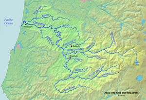 Map of the Umpqua River watershed | |
 Location of the mouth of Pass Creek in Oregon | |
Pass Creek is a tributary of Elk Creek in the Umpqua River basin of the U.S. state of Oregon. It begins at Divide between the Coast Fork Willamette River watershed and the Umpqua watershed along Interstate 5 (I-5) in Lane County. It flows west into Douglas County and continues generally southwest to meet Elk Creek at the city of Drain, 24 miles (39 km) upstream of Elk Creek's confluence with the Umpqua.[3]
From Divide through Curtin to Anlauf, I-5 runs along Pass Creek's upper reaches. Downstream of Anlauf, concurrent highways, Oregon Route 38 and Oregon Route 99, follow the creek to Drain. Named tributaries of Pass Creek from source to mouth are Ward, Bear, Pheasant, Buck, Rock, Sand, and Fitch creeks. Further downstream are Johnson, Krewson, and Hedrick creeks.[3]
Camping
Pass Creek Park, managed by Douglas County, is along the creek near Curtin and I-5 exit 163. The park serves as an overnight campground for recreational vehicles, pickup campers, and tents, as well as a day-use area. Amenities include fire rings, fishing sites, a pavilion, picnic tables, a play structure, restrooms, and showers.[4]
Covered bridge
Pass Creek Bridge, a covered bridge, once carried stagecoaches and then motor vehicles over Pass Creek in Drain before being moved a few hundred feet from its original location in 1987 and reassembled behind the Drain Civic Center.[5] Through 2014, when the city closed the deteriorating bridge completely, it carried pedestrian traffic.[6]
See also
References
- ↑ Source elevation derived from Google Earth search using GNIS source coordinates.
- 1 2 "Pass Creek". Geographic Names Information System. United States Geological Survey. November 28, 1980. Retrieved March 26, 2016.
- 1 2 "United States Topographic Map". United States Geological Survey. Retrieved March 27, 2016 – via Acme Mapper. The map includes mile markers along Elk Creek.
- ↑ "Pass Creek RV Park and Campground". Douglas County, Oregon. 2016. Retrieved March 27, 2016.
- ↑ "Pass Creek Covered Bridge" (PDF). Oregon Department of Transportation. Retrieved March 27, 2016.
- ↑ Pettit, Daniel K. (2016). "Pass Creek Covered Bridge". The Oregon Encyclopedia. Portland State University and the Oregon Historical Society. Retrieved March 27, 2016.