Divide, Oregon
| Divide | |
|---|---|
| Ghost town | |
|
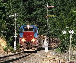
A train passing by Divide | |
 Divide Location within the state of Oregon | |
| Coordinates: 43°45′04″N 123°07′11″W / 43.75111°N 123.11972°WCoordinates: 43°45′04″N 123°07′11″W / 43.75111°N 123.11972°W | |
| Country | United States |
| State | Oregon |
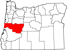
| County | Lane |
| Established | 1900 |
| Elevation | 745 ft (227 m) |
| Time zone | Pacific (PST) (UTC-8) |
| • Summer (DST) | PDT (UTC-7) |
| Area code(s) | 458 and 541 |
| GNIS feature ID | 1119961 |
| Elevation and coordinates derived from the Geographic Names Information System[1] | |
Divide is a ghost town in Lane County, Oregon, United States, located southwest of Cottage Grove, near Interstate 5.[1][2] A post office in Douglas County near a train station on the Southern Pacific Railroad was established on May 31, 1900, and it was closed on January 15, 1921. In 1909, the post office was relisted as a Lane County post office. It may have been moved across county borders, or its county may have changed during a shift in the border between Lane and Douglas counties.[2]
Divide got its name because it approximately marks the boundary between the Willamette River watershed to the north and the Umpqua River watershed to the south, and the boundary between Pass Creek to the west and the Coast Fork Willamette River watershed to the east.[2] In addition, the southern end of the Willamette Valley is near Divide.[3]
References
- 1 2 "Divide". Geographic Names Information System. United States Geological Survey. November 28, 1980. Retrieved August 9, 2011.
- 1 2 3 McArthur, Lewis A.; McArthur, Lewis L. (2003) [1928]. Oregon Geographic Names (7th ed.). Portland, Oregon: Oregon Historical Society Press. pp. 291–292. ISBN 978-0875952772.
- ↑ Writers' Program of the Work Projects Administration in the State of Oregon (1940). Oregon: End of the Trail. American Guide Series. Portland, Oregon: Binfords & Mort. p. 317. OCLC 4874569.