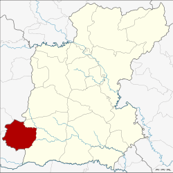
Pathum Rat District
| Pathum Rat ปทุมรัตต์ | |
|---|---|
| Amphoe | |
 Amphoe location in Roi Et Province | |
| Coordinates: 15°38′6″N 103°20′36″E / 15.63500°N 103.34333°ECoordinates: 15°38′6″N 103°20′36″E / 15.63500°N 103.34333°E | |
| Country | Thailand |
| Province | Roi Et |
| Seat | Bua Daeng |
| Area | |
| • Total | 356.9 km2 (137.8 sq mi) |
| Population (2015) | |
| • Total | 53,718 |
| • Density | 147.8/km2 (383/sq mi) |
| Time zone | ICT (UTC+7) |
| Postal code | 45190 |
| Geocode | 4503 |
Pathum Rat (Thai: ปทุมรัตต์) is a district (amphoe) in the southwestern part of Roi Et Province, Thailand.
Geography
Neighboring districts are (from the east clockwise) Kaset Wisai of Roi Et Province, Phayakkhaphum Phisai, Na Dun and Wapi Pathum of Maha Sarakham Province.
History
The minor district (king amphoe was created on 15 June 1963, when the three tambon Bua Daeng, Phon Sung, and Non Sawan were split off from Kaset Wisai District.[1] It was upgraded to a full district on 27 July 1965.[2]
Administration
Central administration
The Pathum Rat District is divided into eight sub-districts (tambon), which are further subdivided into 101 administrative villages (muban).
| No. | Name | Thai | Villages | Pop.[3] |
|---|---|---|---|---|
| 1. | Bua Daeng | บัวแดง | 12 | 8,077 |
| 2. | Dok Lam | ดอกล้ำ | 15 | 7,884 |
| 3. | Nong Khaen | หนองแคน | 14 | 7,671 |
| 4. | Phon Sung | โพนสูง | 9 | 5,013 |
| 5. | Non Sawan | โนนสวรรค์ | 16 | 6,918 |
| 6. | Sa Bua | สระบัว | 17 | 7,881 |
| 7. | Non Sa-nga | โนนสง่า | 10 | 5,533 |
| 8. | Khilek | ขี้เหล็ก | 8 | 4,741 |
Local administration
There are three sub-district municipalities (Thesaban Tambon) in the district:
- Pathum Rat (Thai: เทศบาลตำบลปทุมรัตต์) consisting of parts of the sub-districts Bua Daeng and Non Sa-nga.
- Phon Sung (Thai: เทศบาลตำบลโพนสูง) consisting of the entire sub-district of Phon Sung.
- Non Sawan (Thai: เทศบาลตำบลโนนสวรรค์) consisting of the entire sub-district of Non Sawan.
There are six sub-district administrative organizations (SAO) in the district:
- Bua Daeng (Thai: องค์การบริหารส่วนตำบลบัวแดง) consisting of parts of the sub-district Bua Daeng.
- Dok Lam (Thai: องค์การบริหารส่วนตำบลดอกล้ำ) consisting of the entire sub-district of Dok Lam.
- Nong Khaen (Thai: องค์การบริหารส่วนตำบลหนองแคน) consisting of the entire sub-district of Nong Khaen.
- Sa Bua (Thai: องค์การบริหารส่วนตำบลสระบัว) consisting of the entire sub-district of Sa Bua.
- Non Sa-nga (Thai: องค์การบริหารส่วนตำบลโนนสง่า) consisting of parts of the sub-district of Non Sa-nga.
- Khilek (Thai: องค์การบริหารส่วนตำบลขี้เหล็ก) consisting of the entire sub-district of Khilek.
References
- ↑ ประกาศกระทรวงมหาดไทย เรื่อง แบ่งท้องที่การปกครองอำเภอเกษตรวิสัยตั้งเป็นกิ่งอำเภอ (PDF). Royal Gazette (in Thai). 80 (59 ง): 1507. June 11, 1963.
- ↑ พระราชกฤษฎีกาตั้งอำเภอศรีสวัสดิ์ อำเภอสังขละบุรี อำเภอท่าคันโท อำเภอดอกคำใต้ อำเภอแม่ใจ อำเภอจุน อำเภอขามทะเลสอ อำเภอไพศาลี อำเภอท่าวังผา อำเภอบ้านกรวด อำเภอเด่นชัย อำเภอปทุมรัตต์ อำเภอกะเปอร์ อำเภออากาศอำนวย อำเภอดอนเจดีย์ อำเภอจอมพระ และอำเภอสามโก้ พ.ศ. ๒๕๐๘ (PDF). Royal Gazette (in Thai). 81 (49 ก): 565–569. July 27, 1965.
- ↑ "Population statistics 2015" (in Thai). Department of Provincial Administration. Retrieved 2016-03-24.