Pavlos Melas (municipality)
| Pavlos Melas Παύλος Μελάς | |
|---|---|
 | |
 Pavlos Melas | |
|
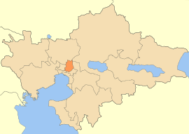
Location within the region 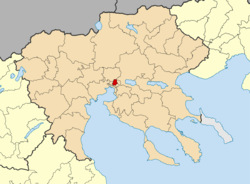 | |
| Coordinates: 40°40′N 22°56′E / 40.667°N 22.933°ECoordinates: 40°40′N 22°56′E / 40.667°N 22.933°E | |
| Country | Greece |
| Administrative region | Central Macedonia |
| Regional unit | Thessaloniki |
| Area | |
| • Municipality | 23.763 km2 (9.175 sq mi) |
| Population (2011)[1] | |
| • Municipality | 99,245 |
| • Municipality density | 4,200/km2 (11,000/sq mi) |
| Time zone | EET (UTC+2) |
| • Summer (DST) | EEST (UTC+3) |
| Website | |
Pavlos Melas is a municipality in the regional unit of Thessaloniki, Central Macedonia, Greece. It was named after the Greek hero of the Macedonian Struggle, Pavlos Melas. It was formed at the administrative reform introduced by the governmental Kallikratis plan (N. 3852 / 7-6-2010). It is the result of the unification of the former municipalities of Efkarpia, Polichni and Stavroupoli.[2] The area of the new Municipality is 23.763 km2.[3] Its population is 99,245 based on the last official census of 2011.[1] The seat of the municipality is in Stavroupoli.[2]
Urbanism
The modern outlook of the Municipality is a result of a gradual town planning which is closely connected to the residential course of action of the northern and western prefecture of the previous urban core of Thessaloniki. Since the homing of refugees - when the first systematic settlement of the area of interest takes place - and at different time zones the advent of new populations broadened its district creating urban pocks of residency that according to the circumstances and the time of development they acquired special town planning and social characteristics. Despite the co-ordinated efforts of the past decades of restraint of urban diffusion, it is still ongoing and characterizes the area of the Municipality, including the areas with especially dense urban web but also regions with greater distance from the city center, legally or illegally developed with less urban characteristics. The immediate proximity of the Municipality with transportational axes of entry and exit of the city, in the past and today, has as a result the mixture of usually incompatible practices with the existence of industrial and craft units, enough of which have been abandoned or dis-function. The wide peri-urban zone of the Municipality apart from the production units includes other activities of metropolitan and regional scale, such as the two hospitals and other fallow green and reforested areas of the peri-urban mountainous zone.
The Municipality of Pavlos Melas like all other municipalities of Greece have the following responsibilities:
- Environment
- Quality of life and orderly function of cities
- Social Protection
- Education, Culture and sports
Finally, among others and in accordance to the internal regulation plan of Municipalities and Communities, Pavlos Melas exerts state responsibilities at a local level. That is responsibilities on matters of urban situation, concerning granting licenses of retail markets, of outdoor itinerant trade, operation of exhibitions, foundation and operation of flee markets e.t.c.
Subdivisions
- Municipal Unit of Efkarpia It is located on the northern side of the Thessaloniki Conurbation and on the northern side of the Municipality of Pavlos Melas. It has a population of 13.905 residents and it includes the following planning sections: Social housing, Old Housing Estate, Travmatioupoli, 4, 5, 6, Efedroupoli, Filothei and Efxinoupoli.
- Municipal Union of Polichni It is located on the northwest side of the Thessaloniki Conurbation and on the east side of the Municipality of Pavlos Melas. It has a population of 39.332 residents and it includes the following planning sections: Elpidos, 3, 4, 5, Meteora below the grove, Old Housing Estate, 8, Pavlou Mela, 11, Above Asylum, Anthokipoi, Nikopoli, 15 and 16
- Municipal Union of Stavroupoli It is located on the west side of the Thessaloniki Conurbation and on the southwest side of the Municipality of Pavlos Melas. It has a population of 46.008 residents and it includes the following planning sections: Terpsithea, Ampelones, Neoktista, Above Asylum, Omonia, Ilioupoli, Pronia and Nikopoli.
History
As already mentioned the systematic and organized residential settlement in the municipality’s district is detected during the refugee era that is 1914 and since. More specifically, during the years of 1913 until 1916 the first refugee wave which includes populations thrown out in 1913 from west Thrace, in 1914 from Asia Minor (Erithrea, Athramitio, Thekeli, Pergamos, Fokaia) but also in 1916 from Pontos. In a report from the Ministry of Finances are mentioned two organized refugee settlements of that period, one in Lembet and one in Triandria. It should be mentioned that the name for the place Lembet is used for the region around Lagada street, north of the military camp of Pavlos Melas which will later be named Stavroupoli.
In 1915 the troops of Endente Cordiale deport in Thessaloniki, the wide area of which will be in the next two years the entrenched military camp and convert with their settlement all the western zone in an immense military camp. The Greek government defines the marshy and fallow land of Zeitenlik as a place of settlement of the allies. With an intermediate limit of Lagada street, the French settled west and around the Lazaristes abbey and the English in the east. The military camp of Pavlos Melas was requisited by the Greek government in order to be used by the Greek army. From maps, photos along with film documentaries we have a good picture of the organization of Zeitenlik camp. In the Lazaristes abbey premises there were the military hospitals no 1 and 3, gas depots, post offices, bakery, stables along with a French school which was founded with the initiative of the French general Sarray for the children of the refugees of the neighboring camp of Lembet.
The 1917 fire and the efforts of the whole redesign the burnt by fire zone will not only affect the city center but also its immediate perimeter. For the treatment of the fire–stricken people camps were set up from the military authorities in Karaisin in Polihni and in Kalamaria but before the end of 1917 the fire stricken populations of Kalamaria were moved to Karaisin camp as well. For an extended period of time until after civil war times refugee camps keep being as small peri – urban villages. The rural exodus meant the fast expansion of those settlements, since a great number of emigrants settled the region because it provided cheap residence and proximity to the areas of production.
Following are, in summary, the most important historical points of interest of the municipality of Pavlos Melas.
- “Lembet Bank” (M.U. Stavroupoli):
It is a tomb of the late Copper age – prime Iron era (2500-950 BC) and 17 redeeming excavations took place on premises, on the top and the slopes of the bank. On the east of the bank and up until the ex military camp of Karatasiou is a cemetery which has been excavated almost completely (20 redeeming excavations) and on which 278 graves have been found dating back to the Archaic and Helenistic period
- Neolithic settlement in the area of today’s Omonoia (M.U.Stavroupoli):
It dates back between 5600 and 4500 BC among the boxed now torrents / streams of Dendropotamos and Platyrematos (Bouboulinas street). In the area approximately 20 private premises have been excavated, without a feasible in situ elevation of the findings. Next to the settlement cemeteries were detected since the Iron period (950-800 BC) and Post Classical times (4th century BC). In opposition to many of the in site findings of Lembet Bank, along with the Neolithic settlement of Omonoia are exhibited on the permanent collections of the Archeological museum of Thessaloniki.
- Complex of seven watermills and a wine-press (on the east branch of Dendropotamos) (Xiropotamos):
Four of these buildings are of the Byzantine era (before 1430) and the rest date back between the 15th and 19th century. This group is of great importance for the Industrial Archeology of Thessaloniki, since it operated since the Byzantine era until recently and it is protected by the Archeological Law. By the survival of the Byzantine complex and its expansion after 1430 it is inferred that Dendropotamos was superfluous in water and the region had organized cultivations with cottages
- Complex of buildings of Lazaristes abbey and the Sisters of Mercy (Terpsithea - Stavroupoli):
That particular complex of buildings was constructed by the monks of the order of St. Vincent of Paul and the Sisters of Mercy in 1883-5 and 1885-92 respectively and they put up mainly orphans and children from Bulgary and operated supplementary since the Sisters of Mercy looked after the children until the age of 15 who then moved to the Lazaristes abbey were they learnt some kind of art or studied in order to become part of the clergy.
- Military Camp of Pavlos Melas:
At around 1895, the Ottoman army, on the grounds of an extended modernizing program, it buys an initial part of landof about 250 hectares. The land is bought by Safiye Hanoun who is the owner of other large stretches on the west side of the town. In 1912 the Greek army will settle at the military camp. From photos of archives of the French military it appears that the grounds were used by the French military allies during the years of 1915-1917. German troops of occupancy will take over the camp in 1940. The Greek army will come back to re-settle in 1945. In 2003 the Ministry of Culture declared the camp as an Ottoman mosque as preservable shells the two long buildings of barracks and the biggest part of the military camp as a historical place. Since the decade of 1970 the camp ceased to be a base of combatant units, the facilities hypofunctioned up until 2006, the time when the camp was definitely abandoned by the army. According to the current regulatory plan of Thessaloniki, the ex-military camp of Pavlos Melas is destined to operate as a hyperlocal green pole of free spaces sport and cultural facilities with reuse of the most important old important military buildings.
- The ex military camp of Karatasiou:
It has an area of approximately 689 square kilometres. During that period 1915-1917 the allies had turned all the available peripheral land in an immense military camp the northwest limits of which must have been around the area of today's Karatasiou military camp.
Culture
The municipality of Pavlos Melas presents a significant number of cultural infrastructures, with balanced spatial distribution on all 3 Municipal Unities. Alongside, in the municipality a number of cultural activities takes place. More specifically there are the structures below:
Cultural Centers:
- Christos Tsakiris Cultural Center
- Cultural center of Meteora
- Cultural center 'Elpidos'
- Cultural center of Efkarpia
- Cultural center of Anthokipoi
Public Library:
- Inside the "Christos Tsakiris" Cultural Center (14.000 books)
- Public Library "Theoklitos Karipidis" (19.800 books)
- Theaters - Public cinemas:
- Theater inside the "Christos Tsakiris" Cultural Center
- Theater of "Ellis Papanayiotou"
- Open theater of "Kria Vrisi"
- Open theater of "Byzantine Watermills"
- Open theater of Efkarpia
- Summer/ open-air cinema "Tzeni Karezi"
Outdoor cultural demonstration spaces:
- Eleftherias square of Ano Ilioupoli
- Meteora square "Alexander the Great park"
- Solonos park
Furthermore, in the municipality of Pavlos Melas the following art groups take action:
- Municipal amateur theatrical group 'Kapnomagazo'
- Municipal amateur theatrical group 'Theatrical workshop of Polihni'
- Photo club 'Opsis'
- Several amateur theatrical groups that function under the supervision of 'Iris' firm
The festivals organized in the municipality of Pavlos Melas is:
- Educational festival
- Byzantine watermills in Polihni festival
- Choir meeting 'Plural Harmony'
- 'Days of Greek Culture' festival
- Meeting of amateur theater companies in the week of Theater every July
- Meeting- calling of new artists 'Anakata'
- Five-day festivals of meeting traditional dance groups 'Crossroad of tradition'
- Five-day music organization entitled 'Iris Music Festival'
Last but not least, it should be mentioned that:
- In the area the presence of cultural associations is intense (10 in Stavroupoli, 10 in Polihni and 12 in Efkarpia)
- Significant cultural activity have many parent and guardian associations of schools of the Municipality
- The enterprise of public benefit of the municipality of Pavlos Melas 'Iris' operates a number of schools and cultural workshops like dance, art, multimedia and computer science
- In four cultural centers of the municipality operate exhibition spaces of a total area 969 square meters
Sports
Significant is the number of sport facilities recorded in the municipality of Pavlos Melas that holds a great number of sport demonstrations.
More specifically as it concerns the sports facilities of the municipality:
- the facilities of the municipal unity of Stavroupoli come to 32
- the facilities of the municipal unity of Polihni come to 24 and
- the facilities of the municipal unity of Efkarpia come to 22.
The above-mentioned facilities include:
- 39 football fields, 5x5, volleyball and basketball courts
- 4 big athletic centers
- 2 closed gyms
- 1 gym of heavy sports
- 32 halls of multiple uses in schools, halls in Centers of Open Protection of Seniors (KAPI) and cultural centers of the municipality.
Finally, it should be mentioned that in the district 41 sport groups / teams are in action.
Sources
- Operational program 2014-2019 of the Municipality of Pavlos Melas Part one Strategic Plan
- Kourti P. (2013), The refugee settlement of west Thessaloniki and the procreation of 'the other side', Scientific yearbook of the Thessaloniki Center of History, Volume 8, Thessaloniki
- Official website of the municipality of Pavlos Melas http://www.pavlosmelas.gr/
- Lazarides S. (1993) Lembet. Thessaloniki publication of the other side
- Code of Municipalities and Communities
References
- 1 2 "Απογραφή Πληθυσμού - Κατοικιών 2011. ΜΟΝΙΜΟΣ Πληθυσμός" (in Greek). Hellenic Statistical Authority.
- 1 2 Kallikratis law Greece Ministry of Interior (Greek)
- ↑ "Population & housing census 2001 (incl. area and average elevation)" (PDF) (in Greek). National Statistical Service of Greece.
Administrative division of the Central Macedonia Region | ||
|---|---|---|
| ||
| Regional unit of Chalkidiki | 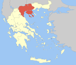 | |
| Regional unit of Imathia | ||
| Regional unit of Kilkis | ||
| Regional unit of Pella | ||
| Regional unit of Pieria | ||
| Regional unit of Serres | ||
| Regional unit of Thessaloniki | ||
| ||