Irakleia, Serres
| Irakleia Ηράκλεια | |
|---|---|
 | |
 Irakleia | |
|
Location within the region 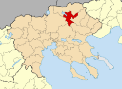 | |
| Coordinates: 41°11′N 23°17′E / 41.183°N 23.283°ECoordinates: 41°11′N 23°17′E / 41.183°N 23.283°E | |
| Country | Greece |
| Administrative region | Central Macedonia |
| Regional unit | Serres |
| Area | |
| • Municipality | 448.8 km2 (173.3 sq mi) |
| Population (2011)[1] | |
| • Municipality | 21,145 |
| • Municipality density | 47/km2 (120/sq mi) |
| • Municipal unit | 12,092 |
| Community[1] | |
| • Population | 3,786 (2011) |
| Time zone | EET (UTC+2) |
| • Summer (DST) | EEST (UTC+3) |
| Vehicle registration | ΕΡ |
| Website | www.dimosiraklias.gr |
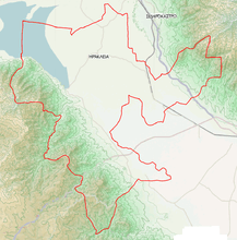
Irakleia (Greek: Ηράκλεια, before 1926: Τζουμαγιά - Tzoumagia[2]) is a municipality in the Serres regional unit, Central Macedonia, Greece. Population 21,145 (2011). The seat of the municipality is the town of Irakleia, which was formerly known as "Lower Jumaya" (in Turkish: Barakli Cuma or Cuma-i Zir ("Lower Juma" in Ottoman Turkish); in Bulgarian: Долна Джумая, Dolna Dzhumaya;[3][4] and in Aromanian: Giumala de Jos).
Municipality
The municipality Irakleia was formed at the 2011 local government reform by the merger of the following 3 former municipalities, that became municipal units:[5]
- Irakleia
- Skotoussa
- Strymoniko
References
- 1 2 "Απογραφή Πληθυσμού - Κατοικιών 2011. ΜΟΝΙΜΟΣ Πληθυσμός" (in Greek). Hellenic Statistical Authority.
- ↑ Name changes of settlements in Greece
- ↑ D.M.Brancoff. "La Macédoine et sa Population Chrétienne". Paris, 1905, p.104, under the name of Barakli Djoumaia
- ↑ Ιστορία του Ελληνικού Έθνους. Εκδοτική Αθηνών, Αθήνα 1978. ISBN 960-213-110-1, σελ. 228-229; Map of the Italian Instituto Geografico de Agostini, showing the distribution of schools, churches, monasteries in the Ottoman vilayet of Saloniki
- ↑ Kallikratis law Greece Ministry of Interior (Greek)
External links
Administrative division of the Central Macedonia Region | ||
|---|---|---|
| ||
| Regional unit of Chalkidiki | 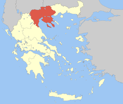 | |
| Regional unit of Imathia | ||
| Regional unit of Kilkis | ||
| Regional unit of Pella | ||
| Regional unit of Pieria | ||
| Regional unit of Serres | ||
| Regional unit of Thessaloniki | ||
| ||
This article is issued from Wikipedia - version of the 9/25/2015. The text is available under the Creative Commons Attribution/Share Alike but additional terms may apply for the media files.