Pennsylvania Route 50
| ||||
|---|---|---|---|---|
 | ||||
| Route information | ||||
| Maintained by PennDOT | ||||
| Length: | 32.7 mi[1] (52.6 km) | |||
| Existed: | 1961[2] – present | |||
| Major junctions | ||||
| West end: |
| |||
|
| ||||
| East end: |
| |||
| Location | ||||
| Counties: | Allegheny, Washington | |||
| Highway system | ||||
| ||||
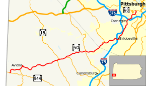
Pennsylvania Route 50 (PA 50) is a 32.7-mile-long (52.6 km) state highway located in western Pennsylvania. The western terminus of the route is at Pennsylvania Route 844 in the Independence Township community of Independence less than a mile from the West Virginia state line. The eastern terminus is at Pennsylvania Route 60 in Crafton Heights. Part of its routing used to be Pennsylvania Route 28, which now terminates in the Pittsburgh neighborhood of Crafton Heights.
Route description
Washington County
PA 50 begins at an intersection with PA 844 in the community of Independence in Independence Township, Washington County, heading northeast on two-lane undivided Avella Road. The road winds north through a mix of farmland and woodland with some homes, curving east. The route winds through more rural areas, passing through P&W Patch and heading into woods as it comes to an intersection with the northern terminus of PA 231. PA 50 turns northeast and heads into the residential community of Avella, curving north before turning east and passing over a Wheeling and Lake Erie Railway line. The route turns south-southeast before quickly turning east and then south-southeast again, running through more of the community. The road leaves Avella and turns east into woodland a short distance to the north of the railroad tracks, crossing the Cross Creek into Cross Creek Township. PA 50 runs through more forested areas to the north of the creek and the railroad tracks, with the road and railroad line turning northeast away from the Cross Creek. The route runs east through more woodland with some fields and homes, passing through Rea and crossing the Wheeling and Lake Erie Railway. The road continues east-northeast through more rural areas to the south of the railroad tracks, passing through Woodrow. PA 50 heads into Mount Pleasant Township and turns northeast, passing under the Wheeling and Lake Erie Railway. The route runs through more agricultural and wooded areas with some residences, coming to an intersection with PA 18. Here, PA 18 turns northeast to form a brief concurrency with PA 50 on Main Street, soon turning to the northwest.[1][3]
PA 50 continues east and passes over a tunnel of the Wheeling and Lake Erie Railway, heading past homes and some businesses as it heads east-northeast through Hickory. The road turns northeast and intersects the northern terminus of PA 519. The route heads into open agricultural areas with some trees and homes, becoming Millers Run Road. PA 50 winds east through more rural areas with some residential development and crosses into Cecil Township, passing through Gilmore. The road runs through wooded areas with some development, coming to a junction with PA 980 in Venice. PA 980 briefly follows PA 50 before heading north, with PA 50 heading through more woodland and commercial development. The route heads into a mix of homes and businesses, turning northeast and heading through Bishop and Cecil. The road continues through more developed areas and widens into a four-lane divided highway.[1][3]
Allegheny County
PA 50 enters South Fayette Township in Allegheny County and becomes an unnamed road, heading through wooded areas with some nearby residential and commercial development. Near Gladden, the road intersects the eastern terminus of PA 978. The route winds northeast near more suburban areas separated by woodland, with the Wheeling and Lake Erie Railway a short distance to the northwest of the road. PA 50 becomes Millers Run Road again and heads east to an interchange with I-79 in a commercial area. Past this interchange, the route turns north-northeast onto four-lane undivided Washington Avenue and crosses the Chartiers Creek into Bridgeville. The road becomes two lanes and runs through the commercial downtown of Bridgeville, becoming a part of the Orange Belt of the Allegheny County belt system at the Station Street intersection, before passing under the Wheeling and Lake Erie Railway. PA 50 passes more homes and businesses, with the Orange Belt turning west at Prestley Road, prior to crossing the Chartiers Creek into Collier Township and heading northeast past several commercial establishments on four-lane divided Washington Pike. The route becomes a four-lane undivided road and runs past more businesses with some homes, passing through Kirwan Heights and coming to a ramp that provides access to I-79 to the west. The road continues north-northeast through areas of residential and commercial development between I-79 to the west and the Chartiers Creek to the east, entering Scott Township and passing more businesses as a divided highway. PA 50 curves northeast and heads into Heidelberg as an undivided road and curves north through residential areas with a few commercial buildings.[1][4]
The route becomes divided again crosses the Chartiers Creek back into Scott Township, becoming Washington Avenue and turning northeast as it passes over the Pittsburgh and Ohio Central Railroad at the Carothers Avenue/Hope Hollow Road intersection. Here, the Yellow Belt joins the road and it becomes undivided as it passes more homes and businesses, turning north and coming into Carnegie. PA 50 narrows to two lanes and runs through residential areas, reaching an intersection with East Main Street in the commercial downtown. At this point, the Yellow Belt turns southwest onto that road while PA 50 heads northeast onto East Main Street, passing downtown businesses before running past a mix of residential and commercial development. The route comes to an interchange with I-376/US 22/US 30 with access through local streets as it crosses back into Scott Township and heads east through more suburban development on Noblestown Road. The road turns northeast and becomes the border between Pittsburgh to the northwest and Green Tree to the southeast as it passes through wooded areas with some nearby homes. PA 50 curves east and north as it passes southeast of Chartiers Cemetery and runs near more residences and businesses. The route curves northeast and east through more wooded residential areas, becoming a part of the Blue Belt at the Baldwick Road intersection. The road gains a center left-turn lane and heads north-northeast past businesses, intersecting the northern terminus of PA 121 where the Blue Belt heads southeast to follow that route. Here, the route turns north to fully enter Pittsburgh and pass more commercial establishments as a three-lane road with two southbound lanes and one northbound lane. PA 50 becomes two lanes and turns northeast into residential neighborhoods, curving northwest before reaching its eastern terminus at PA 60.[1][4]
History
On July 15, 1960, PA 50 was designated to replace the stretch of PA 28 between the West Virginia border and Pittsburgh. This designation change was made to reduce the number of concurrent routes in Pittsburgh. The changes took effect a few months later and signs were changed by spring 1961.[2]
Construction
A seven-month project started Monday, March 30, 2015 and was supposed to be completed in late October in 2015, but it was delayed because of weather.[5] The construction crews poured concrete over the existing road surface and added new stop lights, guard rails, jersey barriers, and new road signs. It was finished in early February and will be connected to Pennsylvania Route 576 also Pennsylvania Turnpike 576 (future I-576).
Major intersections
| County | Location | mi | km | Destinations | Notes |
|---|---|---|---|---|---|
| Washington | Independence Township | 0.0 | 0.0 | Western terminus of PA 50 | |
| Northern terminus of PA 231 | |||||
| Mount Pleasant Township | Western terminus of PA 18 concurrency | ||||
| Eastern terminus of PA 18 concurrency | |||||
| Northern terminus of PA 519 | |||||
| Cecil Township | |||||
| Allegheny | South Fayette Township | Expected to open in 2019.[6] | |||
| Southern terminus of PA 978 | |||||
| Bridgeville | Exit 54 (I-79) | ||||
| Southern terminus of Orange Belt concurrency | |||||
| Northern terminus of Orange Belt concurrency | |||||
| Collier Township | Exit 55 (I-79) | ||||
| Scott Township | Southern terminus of Yellow Belt concurrency | ||||
| Carnegie | Northern terminus of Yellow Belt concurrency | ||||
| Exit 65 (I-376) | |||||
| Pittsburgh | Southern terminus of Blue Belt concurrency | ||||
| Northern terminus of PA 121, northern terminus of Blue Belt concurrency | |||||
| Eastern terminus of PA 50 | |||||
1.000 mi = 1.609 km; 1.000 km = 0.621 mi
| |||||
See also
 U.S. Roads portal
 Pennsylvania portal
 Pittsburgh portal
References
- 1 2 3 4 5 Google (September 7, 2011). "overview of Pennsylvania Route 50" (Map). Google Maps. Google. Retrieved September 7, 2011.
- 1 2 "Designations Of Highways Are Changed". The Evening Standard. Uniontown, PA. July 16, 1960. p. 7. Retrieved August 28, 2015 – via Newspapers.com.

- 1 2 Washington County, Pennsylvania Highway Map (PDF) (Map). PennDOT. 2011. Retrieved May 17, 2011.
- 1 2 Allegheny County, Pennsylvania Highway Map (PDF) (Map). PennDOT. 2011. Retrieved May 25, 2011.
- ↑ "Route 50 work to begin Monday in South Fayette". TribLIVE.com. Retrieved 2016-01-01.
- ↑ Construction on Southern Beltway set for spring Beaver County Times (01/14/2013)
