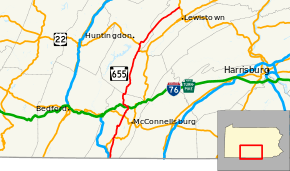
Pennsylvania Route 655
| |||||||
|---|---|---|---|---|---|---|---|
 | |||||||
| Route information | |||||||
| Maintained by PennDOT | |||||||
| Length: | 82.916 mi[1][2] (133.440 km) | ||||||
| Major junctions | |||||||
| South end: | Maryland state line in Thompson Township | ||||||
|
| |||||||
| North end: | Old US 322 in Reedsville | ||||||
| Location | |||||||
| Counties: | Fulton, Huntingdon, Mifflin | ||||||
| Highway system | |||||||
| |||||||

Pennsylvania Route 655 (PA 655) is an 83-mile-long (134 km) north–south state highway located in central Pennsylvania. The southern terminus of the route is at the Mason–Dixon line in Thompson Township, where the road becomes a local road (Pennsylvania Avenue) in Hancock, Maryland. The northern terminus is at old U.S. Route 322 in Reedsville.
History
Most of PA 655 was once Pennsylvania Route 76. From 1930 to 1964, PA 76 occupied what is now PA 655 from the Maryland state line to Pennsylvania Route 829 in Cass Township, as well as PA 829 from Cass to Mill Creek and PA 655 from Mill Creek to Reedsville.
Major intersections
| County | Location | mi[1] | km | Destinations | Notes |
|---|---|---|---|---|---|
| Fulton | Thompson Township | 0.000 | 0.000 | Pennsylvania Avenue – Hancock | Maryland state line |
| 2.075 | 3.339 | Eastern terminus of PA 484 | |||
| Belfast Township | 8.969 | 14.434 | South end of US 522 concurrency | ||
| 9.815 | 15.796 | South end of US 522 concurrency | |||
| Licking Creek Township | 21.161 | 34.055 | |||
| Taylor Township | 26.474 | 42.606 | Waterfall Road to | ||
| 33.368 | 53.701 | Southern terminus of PA 913 | |||
| Huntingdon | Clay Township | 40.026 | 64.416 | South end of PA 994 concurrency | |
| 40.126 | 64.577 | North end of PA 994 concurrency | |||
| Cass Township | 43.395 | 69.837 | Southern terminus of PA 829 | ||
| Brady Township | 56.794 | 91.401 | South end of US 22 concurrency | ||
| Mill Creek | 58.207 | 93.675 | North end of US 22 concurrency | ||
| Mifflin | Union Township | 74.605 | 120.065 | Eastern terminus of PA 305 | |
| Brown Township | 82.703 | 133.098 | Interchange | ||
| 82.916 | 133.440 | Old US 322 (Tea Creek Road / North Main Street) – Reedsville, Yeagertown, Milroy | |||
1.000 mi = 1.609 km; 1.000 km = 0.621 mi
| |||||
PA 655 Truck
| |
|---|---|
| Location: | Hustontown |
Pennsylvania Route 655 Truck is a truck route of PA 655 that bypasses a weight-restricted bridge over Saddlers Run on which trucks over 36 tons and combination loads over 40 tons are prohibited. It was signed in 2013.
See also
 U.S. Roads portal
 Pennsylvania portal
References
- 1 2 Bureau of Maintenance and Operations (January 2015). Roadway Management System Straight Line Diagrams (Report) (2015 ed.). Pennsylvania Department of Transportation. Retrieved June 30, 2015.
- Fulton County (PDF)
- Huntingdon County (PDF)
- Mifflin County (PDF)
- ↑ Google (June 26, 2013). "Pennsylvania Route 655" (Map). Google Maps. Google. Retrieved June 26, 2013.