Petah Tikva
Petah Tikva
| ||
|---|---|---|
| Hebrew transcription(s) | ||
| • Also spelled |
Petah Tiqwa (official) Petach Tikvah (unofficial) | |
 | ||
| ||
 Petah Tikva | ||
| Coordinates: 32°05′19.78″N 34°53′10.8″E / 32.0888278°N 34.886333°ECoordinates: 32°05′19.78″N 34°53′10.8″E / 32.0888278°N 34.886333°E | ||
| Country | Israel | |
| District | Central | |
| Founded | 1878 | |
| Government | ||
| • Type | City (from 1937) | |
| • Mayor | Itzik Braverman | |
| Area | ||
| • Total | 35,868 dunams (35.868 km2 or 13.849 sq mi) | |
| Population (2015)[1] | ||
| • Total | 230,984 | |
| Name meaning | Opening of hope | |

Petah Tikva (Hebrew: פֶּתַח תִּקְוָה, IPA: [ˈpetaχ tikˈva], "Opening of Hope"; Arabic: بتاح تكفا) known as Em HaMoshavot ("Mother of the Moshavot"), is a city in the Central District of Israel, 10.6 km (6.59 mi) east of Tel Aviv. It was founded in 1878, mainly by religious orthodox Jews, also known as the Old Yishuv, and became a permanent settlement in 1883 with the financial help of Baron Edmond de Rothschild.
In 2015 the city had a population of 230,984. The population density is approximately 6,277 inhabitants per square kilometre (16,260/sq mi). Petah Tikva's jurisdiction covers 35,868 dunams (~35.9 km2 or 15 sq mi).
Etymology
The name of Petah Tikva was chosen by its founders in 1878 from the prophecy of Hosea (2:15, 2:17 Jewish), "And I will give her vineyards from thence, and the Valley of Achor for an opening of hope: and she shall sing there, as in the days of her youth, and as in the day when she came up out of the land of Egypt."
Petah Tikva's emblem appears on a postage stamp designed by Yitzhak Goldenhirsch, a founding member of Petah Tikva. The plow symbolizes Petah Tikva's origins as an agricultural settlement, the field symbolizes the drying of the Yarkon River swamps and cultivation of the land, and the orange tree symbolizes Petah Tikva's citrus industry, starting with the first tree planted by Rabbi Aryeh Leib Frumkin.
History
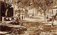
Petah Tikva was founded in 1878 by religious pioneers from Europe, who were led by Yehoshua Stampfer, Moshe Shmuel Raab, Yoel Moshe Salomon, Zerach Barnett,[2] and David Gutmann, as well as Lithuanian Rabbi Aryeh Leib Frumkin who built the first house there.[3] It was the first modern Jewish agricultural settlement in Ottoman Southern Syria (hence its nickname as "Mother of the Moshavot" and has since grown to become one of Israel's most populous urban centers.
Originally intending to establish a new settlement in the Achor Valley, near Jericho, the pioneers purchased land in that area. However, Abdülhamid II cancelled the purchase and forbade them from settling there, but they retained the name Petah Tikva as a symbol of their aspirations.
Undaunted, the settlers purchased a modest area (3.40 square kilometres (1.31 sq mi)) from the village of Mulabbis (variants: Mlabbes, Um-Labbes), near the source of the Yarkon River. The Sultan allowed the enterprise to proceed, but because their purchase was located in what was a malarial swamp, they had to evacuate when the malaria spread, founding the town of Yehud near the Arabic village Yehudiyya about 20 kilometres (12 mi) to the south (itself, founded on the site of the ancient Israelite/Jewish town of Yehud).[4] With the financial help of Baron Edmond de Rothschild they were able to drain the swamps sufficiently to be able to move back in 1883, joined by immigrants of the First Aliyah, and later the Second Aliyah.
During the Sinai and Palestine Campaign of World War I, Petah Tikva served as a refugee town for residents of Tel Aviv and Jaffa, following their exile by the Ottoman authorities due to their refusal to serve the Ottoman army to fight the invading British forces. The town suffered heavily as it lay between the Ottoman and British fronts during the war.
Petah Tikva became the school for thousands of pioneer workers, who studied the craft of farming there before they ventured out to establish dozens of settlements in all parts of the country. The agricultural schools are still active to this day. Petah Tikva was also the birthplace of the Labor Zionist Movement, inspired and encouraged by the writings of A. D. Gordon who lived in the town.
The first recorded Arab attack on Jews in what would become Israel took place in Petah Tikva in 1886.[5] Petah Tikva was also the scene of Arab rioting in May 1921, which left four Jews dead.[6]
In the early 1920s, industry began to develop in the Petah Tikva region. In 1921, Petah Tikva was given the status of a local council by the British authorities. According to a census conducted in 1931 by the British Mandate authorities, Petah Tikva had a population of 6880 inhabitants, in 1688 houses.[7] In 1937 it was recognized as a city. Its first mayor, Shlomo Stampfer, was the son of one of its founders, Yehoshua Stampfer.
Petah-Tikva, which largely depended on citrus farming, was considered by both the British government and the Jaffa Electric Company as a potentially important consumer of electricity for irrigation. The Auja Concession, which was given to the Jaffa Electric Company on 1921, specifically referred to the relatively large Jewish settlement of Petah-Tikva. But it was only in late 1929 that the company submitted an irrigation scheme for Petah-Tikva, and it was yet to be approved by the government in 1930.[8]
In the 1930s, the pioneering founders of Kibbutz Yavneh from the Religious Zionist movement immigrated to the British Mandate of Palestine, settling near Petah Tikva on land purchased by a Jewish-owned German company. Refining the agricultural skills they learned in Germany, these pioneers began in 1941 to build their kibbutz in its intended location in the south of Israel, operating from Petah Tikva as a base.
Urban development
After the creation of the State of Israel in 1948, several adjoining villages – Amishav and Ein Ganim to the east (named after the biblical village (Joshua 15:34)), Kiryat Matalon to the west, towards Bnei Brak, Kfar Ganim and Mahaneh Yehuda to the south and Kfar Avraham on the north – were merged into the municipal boundaries of Petah Tikva, giving it a significant population boost to 22,000.
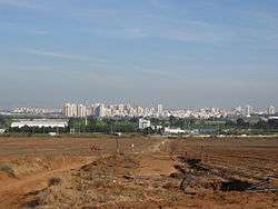
Nowadays, with a population of over two hundred thousand inhabitants Petah Tikva is the third most populous city in the Tel Aviv Metropolitan Area ("Gush Dan").
Petah Tikva is divided into 33 neighborhoods for municipal purposes.[9]
Economy
Petah Tikva is the second-largest industrial sector in Israel after the northern city of Haifa. The industry is divided into three zones—Kiryat Aryeh (named after Aryeh Shenkar, founder and first president of the Manufacturers Association of Israel and a pioneer in the Israeli textile industry), Kiryat Matalon (named after Moshe Yitzhak Matalon), and Segula, and includes textiles, metalwork, carpentry, plastics, processed foods, tires and other rubber products, and soap.
Numerous high-tech companies and start-ups have moved into the industrial zones of Petah Tikva, which now house the Israeli headquarters for the Oracle Corporation, IBM, Intel, Alcatel-Lucent, ECI Telecom, and GlaxoSmithKline Pharmecuticals. The largest data center in Israel, operated by the company TripleC, is also located in Petah Tikva.[10] Furthermore, the Israeli Teva company, the world's largest generic drug manufacturer, is headquartered in Petah Tikva. One of Israel's leading food processing corporations, Osem opened in Petah Tikva in 1976 and has since been joined by the company's administrative offices, distribution center and sauce factory. Strauss is also based in Petach Tikva.
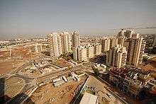
Over time, the extensive citrus groves that once ringed Petah Tikva have disappeared as real-estate developers acquired the land for construction projects. Many new neighborhoods are going up in and around Petah Tikva. A quarry for building stone is located east of Petah Tikva.
As well as general hi-tech firms, Petah Tikva has developed a position as a base for many communications firms. As such, the headquarters of the Bezeq International international phone company is located in the Kiryat Matalon industrial zone as are those of the 012 Smile Internet Service Provider. The headquarters of Tadiran Telecom are in the Ramat Siv industrial zone. Arutz Sheva, the right wing Religious Zionist Israeli media network operates an internet radio studio in Petah Tikva, where Arutz Sheva internet TV is located as well as the printing press for its B'Sheva newspaper.
The Israeli secret service, Shin Bet, has an interrogation facility in Petah Tikva.[11]
Transportation
Petah Tikva is served by a large number of buses. A large number of intercity Egged buses stop there, and the city has a network of local buses operated by the Kavim company. The Dan bus company operates lines to Ramat Gan, Bnei Brak and Tel Aviv.
Petah Tikva's largest bus terminal is the Petah Tikva Central Bus Station (Tahana Merkazit), while other major stations are located near Beilinson Hospital and Beit Rivka. A rapid transit/light rail system is in the works that will connect Petah Tikva to Bnei Brak, Ramat Gan, Tel Aviv and Bat Yam.
Israel Railways maintains two suburban railroad stations in Segula and Kiryat Aryeh, in the northern part of the city. A central train station near the main bus station is envisioned as part of Israel Railways's long-term expansion plan. There are eight taxi fleets based in Petah Tikva, and the city is bordered by three of the major vehicle arteries in Israel: Geha Highway (Highway 4) on the west, the Trans-Samaria Highway (Highway 5) on the north, and the Trans-Israel Highway (Highway 6) on the east.
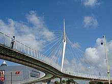
Santiago Calatrava's bridge, a 164 feet (50 m) long span Y-shaped cable-stayed pedestrian three-way bridge connecting Rabin Hospital to a shopping mall, a residential development and a public park. The structure is supported from a 95-foot (29 m) high inclined steel pylon, which is situated where the three spans intersect. Light in construction, the bridge is built principally of steel with a glass-paved deck.[12]
Local government
Petah Tikva's history of government goes back to 1880, when the pioneers elected a council of seven members to run the new colony. From 1880 to 1921, members of the council were David Meir Guttman, Yehoshua Stampfer, Ze'ev Wolf Branda, Abraham Ze'ev Lipkis, Yitzhak Goldenhirsch, Chaim Cohen-Rice, Moshe Gissin, Shlomo Zalman Gissin and Akiva Librecht. This governing body was declared a local council in 1921, and Petah Tikva became a city in 1937. Kadima, the political party founded by former Israeli prime minister Ariel Sharon and now headed by Tzipi Livni, has its headquarters in Petah Tikva.[13]
Council heads
- Shlomo Zalman Gissin (1921)
- Pinchas Meiri (1922–1928)[14]
- Shlomo Stampfer (1928–1937)
Mayors
- Shlomo Stampfer (1938–1940)
- Yosef Sapir (1940–1950)
- Mordechai Kraufman (1951)
- Pinchas Rashish (1951–1966)
- Yisrael Feinberg (1966–1978)
- Dov Tavori (1978–1989)
- Giora Lev (1989–1999)
- Yitzhak Ohayon (1999–2013)
- Uri Ohad (2013)
- Itzik Braverman (2013–present)
Schools and religious institutions
Petah Tikva is home to 300 educational institutions from kindergarten through high school, catering to the secular, religious and Haredi populations. There are over 43,000 students enrolled in these schools, which are staffed by some 2,400 teachers. In 2006, five schools participated in the nationwide Mofet program, which promotes academic excellence. Petah Tikva has seventeen public libraries, the main one located in the city hall building.[15]
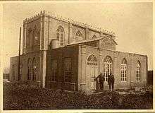
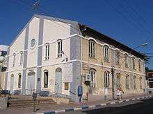
Some 70,000 Orthodox Jews live in Petah Tikva. The community of Petah Tikva is served by 300 synagogues,[16] including the 120-year-old Great Synagogue,[17] eight mikvaot (ritual baths)[18] and two major Haredi yeshivot, Lomzhe Yeshiva and Or-Yisrael (founded by the Chazon Ish, Rabbi Avraham Yeshayahu Karelitz). Yeshivat Hesder Petah Tikva, a modern-orthodox Hesder Yeshiva affiliated with the Religious Zionist movement, directed by Rabbi Yuval Cherlow, is also located in Petah Tikva. Additionally, Rav Michael Laitman, PhD in Philosophy and Kabbalah, daily leads 200-300 students and hundreds of thousands virtually (some estimates of up to 2 million) in the method of Kabbalah learned from his teacher Rav Baruch Shalom HaLevi Ashlag, known as the RABASH.
Petah Tikva has two cemeteries: Segula Cemetery, east of the city, and Yarkon Cemetery, to the northeast.
Health care

Six hospitals are located in the city. The Rabin Medical Center Beilinson complex includes the Beilinson Medical Center, the Davidoff Oncologic Center, the Geha Psychiatric Hospital, the Schneider Pediatric Hospital and Tel Aviv University's Faculty of Medical Research. Other medical facilities in Petah Tikva are HaSharon Hospital, the Beit Rivka Geriatric Center, the Kupat Holim Medical Research Center and a private hospital, Ramat Marpeh, affiliated with Assuta Hospital. The Schneider Pediatric Center is one of the largest and most modern children's hospitals in the Middle East. In addition, there are many family health clinics in Petah Tikva as well as Kupat Holim clinics operated by Israel's Health maintenance organizations.
Landmarks and cultural institutions
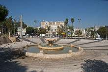
Petah Tikva's Independence Park includes a zoo at its northeastern edge, the Museum of Man and Nature, a memorial to the victims of the 1921 Arab riots, an archaeological display, Yad Labanim soldiers memorial, a local history museum, a Holocaust museum and the Petah Tikva Museum of Art.[19][20]
Arab–Israeli conflict
During the Second Intifada, Petah Tikva suffered three terrorist attacks: On May 27, 2002, a suicide bomber blew himself up at a small cafe outside a shopping mall, leaving two dead, including a baby;[21] on December 25, 2003, a suicide bomber blew himself up at a bus stop near the Geha bridge, killing 4 civilians, and on February 5, 2006, a Palestinian got into a shuttle taxi, pulled out a knife, and began stabbing passengers killing two of them, but a worker from a nearby factory hit him with a log, subduing him.
Sports
The main stadium in Petah Tikva is the 11,500-seat HaMoshava Stadium. Petah Tikva has two football teams – Hapoel Petah Tikva F.C. and Maccabi Petah Tikva F.C.. The local baseball team, the Petach Tikva Pioneers, played in the inaugural 2007 season of the Israel Baseball League. The league folded the following year. In 2014, Hapoel Petah Tikva's women's soccer team recruited five Arab-Israeli women to play on the team. One of them is now a team captain.[22]
Notable residents

- Yehuda Amichai (1924–2000), poet
- Hanoch Bartov (b. 1926 in Petah Tikva), author
- Moran Buzovski (b. 1992), Olympic rhythmic gymnast
- Tal Burstein (b. 1980 in Petah Tikva), basketball player
- Shmuel Dayan (1891–1968), Zionist activist
- Israel Finkelstein (b. 1949 in Petah Tikva), archaeologist
- Dudu Fisher (b. 1951 in Petah Tikva), cantor and stage performer
- Zehava Gal-On (b. 1956), Meretz politician
- A. D. Gordon (1856–1922), Labor Zionist ideologue
- Tamar Gozansky (b. 1940 in Petah Tikva), politician
- Avraham Grant (b. 1955 in Petah Tikva), football coach
- Tzofit Grant (b. 1964 in Petah Tikva), television personality
- Hannah Barnett-Trager (1870–1943), wrote about early Petah Tikva[23]
- Simcha Jacobovici (b. 1953 in Petah Tikva), filmmaker
- Yosef Karduner (b. 1969 in Petah Tikva), Hasidic singer-songwriter
- Haim Kaufman (1934–1995), Knesset member
- Yehoshua Kenaz (b. 1937 in Petah Tikva), novelist
- Itzik Kol (1932–2007), television and movie producer
- Alona Koshevatskiy (b. 1997), Olympic rhythmic gymnast
- Amnon Krauz (b. 1952), Olympic swimmer
- Karina Lykhvar (b. 1998), Olympic rhythmic gymnast
- Samir Naqqash (1938–2004), Iraqi-Jewish author
- Zvi Nishri (Orloff) (1878–1973), physical education pioneer
- Uri Orbach (1960–2015), The Jewish Home politician, journalist and writer
- Elyakum Ostashinski (1909–1983, b. in Petah Tikva), first mayor of Rishon LeZion
- Leah Rabin (1928–2000), wife of Israeli prime minister Yitzhak Rabin
- Neta Rivkin (b. 1991), rhythmic gymnast
- Pnina Rosenblum (b. 1954 in Petah Tikva), actress, fashion model, businesswoman and politician
- Michal Rozin (b. 1969), Meretz politician
- Rami Saari (b. 1963 in Petah Tikva), linguist
- Dan Shechtman (b. 1941), winner of Nobel Prize for Chemistry[24]
- Giora Spiegel (b. 1947 in Petah Tikva), soccer player and coach
- Nahum Stelmach (1936–1999), soccer player
- Pnina Tamano-Shata (b. 1981), Yesh Atid politician
International relations
Twin towns — sister cities
Petah Tikva is twinned with:
|
|
See also
References
- ↑ "List of localities, in Alphabetical order" (PDF). Israel Central Bureau of Statistics. Retrieved 16 October 2016.
- ↑ זאב וולף ברנדה ז"ל [Ze'ev Wolf Branda memorial] (in Hebrew). Rishonim.org.il. Retrieved September 16, 2011.
- ↑ "Future Tense – Israel at 60: A Dream Fulfilled". Office of the Chief Rabbi. December 2007. Archived from the original on June 13, 2010. Retrieved 16 April 2012.
- ↑ Yaari, Avraham (1958). The Goodly Heritage: Memoirs Describing the Life of the Jewish Community of Eretz Yisrael From the Seventeenth to the Twentieth Centuries. (Translated and abridged by Israel Schen; edited by Isaac Halevy-Levin). Jerusalem: Youth and Hechalutz Dept. of the Zionist Organization. p. 93.
- ↑ "Frumkin News – Newsletter No. 34". The Frumkin Family Website. September 2002. Retrieved October 21, 2008.
- ↑ "Petah Tikvah". Jewish Agency for Israel. Retrieved October 21, 2008.
- ↑ Mills, 1932, p. 14
- ↑ Shamir, Ronen (2013). Current Flow: The Electrification of Palestine. Stanford University Press. ISBN 978-0804787062.
- ↑ "Connect to the Neighborhood". Petah Tikva municipality. Archived from the original on April 11, 2008. Retrieved July 19, 2008.
- ↑ Thecom.co.il (Hebrew) Archived November 29, 2010, at the Wayback Machine.
- ↑ "Kept in the Dark". B'Tselem. October 2010. Retrieved September 15, 2011.
- ↑ "Calatrava in Israel: Museum exhibition lands 's Calatrava first project in Israel". World Architecture News. December 15, 2006. Retrieved February 5, 2014.
- ↑ Hoffman, Gil (September 20, 2007). "Olmert Moves to Keep Kadima United". The Jerusalem Post. Archived from the original on September 23, 2011. Retrieved February 5, 2014.
- ↑ הנהגת הישוב, השלטון המקומי והעומדים בראשם [Community Leadership, local government and their leaders] (in Hebrew). Petah Tikva Summit. Retrieved September 16, 2011.
- ↑ "Petah Tikva today". Koblenz–Petah Tikva Friendship Circle. Retrieved November 6, 2013.
- ↑ "Places to Live – Petah Tikvah". Tehilla – Pilot Trips. Archived from the original on March 23, 2008. Retrieved October 21, 2008.
- ↑ Stoil, Rebecca Anna (May 4, 2006). "Petah Tikva Synagogue Desecrated". The Jerusalem Post, cited in Pogrom.co.il. Retrieved October 21, 2008.
- ↑ "List of Mikvaot in the City". Petah Tikva municipality. Archived from the original on January 1, 2009. Retrieved October 21, 2008.
- ↑ Tamar Berger (Summer 2002). "Sleep, Teddy Bear, Sleep: Independence Park, Petach Tikva: An Israeli Realm of Memory". Israel Studies. Indiana University Press. 2 (2): 1–32. doi:10.2979/isr.2002.7.2.1. JSTOR 30245584.
- ↑ "Petach Tikva Museum Hosted at Leumi Bet Mani House". Bank Leumi. Retrieved 2013-06-19.
- ↑ "2000-2006: Major Terror Attacks". Israel Ministry of Foreign Affairs. Retrieved September 16, 2011.
- ↑ Israeli soccer team breaks new ground: Recruits Arab women
- ↑ Pioneers in Palestine: Stories of One of the First Settlers in Petach Tikvah. G. Routledge & sons, Limited. 1923.
- ↑ Shtull, Asaf (2011-04-01). "Clear as crystal". Haaretz. Retrieved 2013-06-19.
- ↑ "Trondheims offisielle nettsted – Vennskapsbyer" (in Norwegian). Trondheim.com. Archived from the original on September 27, 2011. Retrieved September 16, 2011.
External links
| Wikimedia Commons has media related to Petah Tikva. |
| Wikivoyage has a travel guide for Petah Tikva. |