Phrae
| Phrae แพร่ | |
|---|---|
| Town | |
|
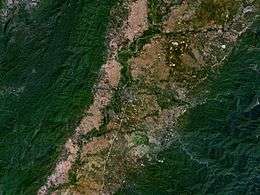
NASA picture of Phrae town among the Phi Pan Nam Mountains | |
 Phrae | |
| Coordinates: 18°8′43″N 100°8′31″E / 18.14528°N 100.14194°E | |
| Country |
|
| Provinces | Phrae Province |
| Elevation | 159 m (522 ft) |
| Population (2005) | 17,971 |
| Time zone | UTC+7 (UTC+7) |
Phrae (Thai: แพร่; pronounced [pʰrɛ̂ː]) is a town (thesaban mueang) in northern Thailand, capital of Phrae Province.
The town covers the whole tambon Nai Wiang of the Mueang Phrae district. It has an area of 9 km² and a population of 17,971 according to the 2005 census. Phrae is 555 km north of Bangkok.[1]
Geography
Phrae lies on the Yom River, at an elevation of 159 metres (522 ft).[2] The town is mostly built on the east side of the river, but some outlying parts are built on the west side of the river and are connected to the main part by bridges. There are hills both to the east and west of the town; the Phlueng Range to the east are higher, reaching about 800 metres (2,600 ft) above sea level, whereas the Phi Pan Nam Range to the west are about 500 metres (1,600 ft) above sea level.
At Phae Muang Phi, a few kilometres north of Phrae, there is an impressive landscape of mushroom rocks and distinctive pillars shaped by natural erosive action.[3]
Climate
Phrae has a tropical savanna climate (Köppen climate classification Aw). Winters are dry and warm. Temperatures rise until April, which is very hot with the average daily maximum at 37.6 °C (99.7 °F). The monsoon season runs from May through October, with heavy rain and somewhat cooler temperatures during the day, although nights remain warm.
| Climate data for Phrae (1981–2010) | |||||||||||||
|---|---|---|---|---|---|---|---|---|---|---|---|---|---|
| Month | Jan | Feb | Mar | Apr | May | Jun | Jul | Aug | Sep | Oct | Nov | Dec | Year |
| Record high °C (°F) | 35.6 (96.1) |
38.5 (101.3) |
41.7 (107.1) |
43.6 (110.5) |
43.0 (109.4) |
40.5 (104.9) |
37.5 (99.5) |
37.5 (99.5) |
35.8 (96.4) |
36.5 (97.7) |
35.8 (96.4) |
34.9 (94.8) |
43.6 (110.5) |
| Average high °C (°F) | 31.2 (88.2) |
33.7 (92.7) |
36.3 (97.3) |
37.6 (99.7) |
35.3 (95.5) |
33.6 (92.5) |
32.6 (90.7) |
32.3 (90.1) |
32.4 (90.3) |
32.1 (89.8) |
31.2 (88.2) |
30.0 (86) |
33.2 (91.8) |
| Daily mean °C (°F) | 22.3 (72.1) |
24.6 (76.3) |
27.9 (82.2) |
30.0 (86) |
29.0 (84.2) |
28.2 (82.8) |
27.7 (81.9) |
27.4 (81.3) |
27.2 (81) |
26.5 (79.7) |
24.4 (75.9) |
21.8 (71.2) |
26.4 (79.5) |
| Average low °C (°F) | 15.7 (60.3) |
17.5 (63.5) |
21.2 (70.2) |
24.3 (75.7) |
24.7 (76.5) |
24.7 (76.5) |
24.4 (75.9) |
24.3 (75.7) |
24.0 (75.2) |
23.0 (73.4) |
19.7 (67.5) |
15.9 (60.6) |
21.6 (70.9) |
| Record low °C (°F) | 7.4 (45.3) |
9.4 (48.9) |
9.9 (49.8) |
19.0 (66.2) |
16.1 (61) |
20.0 (68) |
20.0 (68) |
20.5 (68.9) |
18.5 (65.3) |
14.6 (58.3) |
9.2 (48.6) |
5.0 (41) |
5.0 (41) |
| Average rainfall mm (inches) | 5.8 (0.228) |
8.8 (0.346) |
27.6 (1.087) |
82.1 (3.232) |
178.1 (7.012) |
138.8 (5.465) |
154.2 (6.071) |
205.5 (8.091) |
191.7 (7.547) |
88.8 (3.496) |
25.6 (1.008) |
7.8 (0.307) |
1,114.8 (43.89) |
| Average rainy days | 1.1 | 1.6 | 3.0 | 7.0 | 14.7 | 16.9 | 18.9 | 19.9 | 18.2 | 10.9 | 3.8 | 1.0 | 117.0 |
| Average relative humidity (%) | 74 | 68 | 62 | 64 | 74 | 79 | 81 | 83 | 84 | 83 | 79 | 76 | 76 |
| Mean monthly sunshine hours | 257.3 | 243.0 | 238.7 | 204.0 | 198.4 | 117.0 | 120.9 | 117.8 | 144.0 | 182.9 | 216.0 | 220.1 | 2,260.1 |
| Mean daily sunshine hours | 8.3 | 8.6 | 7.7 | 6.8 | 6.4 | 3.9 | 3.9 | 3.8 | 4.8 | 5.9 | 7.2 | 7.1 | 6.2 |
| Source #1: Thai Meteorological Department[4] | |||||||||||||
| Source #2: Office of Water Management and Hydrology, Royal Irrigation Department (sun and humidity)[5] | |||||||||||||
Culture
Wat Chorm Sawan and Wat Phra That Cho Hae are two important Buddhist temples in Phrae. The latter is located on a hill, 9 km away from the town center.[6]
Transportation
The main road through Phrae is Route 101, which begins in Nan to the north, passes through Phrae, and leads to Sawankhalok, Sukhothai and finally Kamphaeng Phet.
Phrae Airport is a small airport in Mueang Mo, on the east side of town. It handles only domestic flights from Don Mueang (DMK).[7]
References
- ↑ "Phrae Province". Phrae Province. Retrieved 18 May 2015.
- ↑ "Phrae, Thailand". Falling Rain Genomics. Retrieved 1 February 2013.
- ↑ "Pae Mueng Pee". Tourism Authority of Thailand (TAT). Retrieved 13 May 2015.
- ↑ "Climatological Data for the Period 1981–2010". Thai Meteorological Department. p. 3. Retrieved 31 July 2016.
- ↑ "ปริมาณการใช้น้ำของพืชอ้างอิงโดยวิธีของ Penman Monteith (Reference Crop Evapotranspiration by Penman Monteith)" (PDF) (in Thai). Office of Water Management and Hydrology, Royal Irrigation Department. p. 21. Retrieved 31 July 2016.
- ↑ "Phrae". Tourism Authority of Thailand (TAT). Retrieved 13 May 2015.
- ↑ "(PRH) Phrae Airport Overview". Flightstats. Retrieved 13 May 2015.
External links
| Wikimedia Commons has media related to Phrae. |
 Phrae travel guide from Wikivoyage
| ||