Khon Kaen
| Khon Kaen ขอนแก่น | |
|---|---|
| City Municipality | |
|
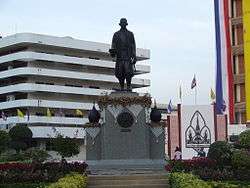
Rama IV monument, Khon Kaen University | |
 Khon Kaen Khon Kaen | |
| Coordinates: 16°26′N 102°50′E / 16.433°N 102.833°ECoordinates: 16°26′N 102°50′E / 16.433°N 102.833°E | |
| Country | Thailand |
| Province | Khon Kaen |
| Amphoe | Muang Khon Kaen |
| Government | |
| • Type | City municipality |
| • Mayor | Peerapon Pattabapeeradech |
| Area | |
| • Total | 46 km2 (18 sq mi) |
| Population (2010) | |
| • Total | 113,754 |
| • Density | 2,500/km2 (6,400/sq mi) |
| Registered residents only | |
| Time zone | ICT (UTC+7) |
| Website | www.kkmuni.go.th/ |
Khon Kaen (Thai: ขอนแก่น, pronounced [kʰɔ̌(ː)n kɛ̀n]) is one of the four major cities of Isan, Thailand, also known as the "big four of Isan", the others being Udon Thani, Khorat, and Ubon Ratchathani. It is the capital of Khon Kaen Province and the Khon Kaen District. Khon Kaen lies 450 kilometres (280 mi) north-northeast of Bangkok.[1]
Geography and demography
Khon Kaen is on the Khorat Plateau, and is the center of the mid-northeastern provincial group of Thailand, according to the Thai government. Its geographical location is 16°26′N 102°50′E / 16.433°N 102.833°E. The city has a population of 113,754.
Regional importance
Khon Kaen is a regional center for education, financial institutions, government offices, and transportation in the northeastern region. The city is also an industrial center, especially for the region's silk trade, as well as an agricultural area.[2][3] Khon Kaen has played host to a number of regional conferences, such as the ASEAN Regional Forum and United Nations meetings.[4] The Lao People's Democratic Republic maintains the office of Consulate-General on Phothisan Road.
Khon Kaen has ever been one of the major cities in Thailand's National Economic and Social Development Plan, along with Chiang Mai, Songkhla, Nakhon Ratchasima, and Chonburi. It is home to the campuses of Rajamangala University and Khon Kaen University, the largest university in the northeast, with a student population of around 25,000.
Strategically important for the Isan region's infrastructure, Khon Kaen Airport was raised to international standards in 2005, with the opening of a new terminal. However, despite efforts to expand services, as of November 2014, only five airlines (Thai Airways, Thai Air Asia, Nok Air, Thai Smile, and Kan Air) use the airport. Thai Airways operates two flights a day to Bangkok (BKK–Suvarnabhumi) and Air Asia (Thai Air Asia) serves Bangkok (DMK–Don Mueang) with four flights a day. Nok Air serves Bangkok (DMK) with three flights a day. Thai Smile flys to Bangkok (DMK) three times a day. Kan Air flies daily to Chiang Mai.[5]
The city is bisected by Mithraphap Road, also known as "Friendship Highway", or "Highway 2", the road linking Bangkok to the Thai-Lao Friendship Bridge. A modern, multi-lane by-pass enables through-traffic to avoid the city centre to the west, and connects to the airport and to the main roads to Kalasin and Maha Sarakham in the east, and Udon Thani in the north.
The city can be easily navigated by driving along either of the two north-south main roads: Na Muang and Klang Muang, which are east and parallel to the Friendship Highway. In addition, there are two main east-west roads: Srichan Road and Prachasamosorn Road, leading east to the city of Kalasin, and west to the airport, as well as to other small villages.
Climate
Khon Kaen's climate is categorised as tropical savanna (Köppen climate classification Aw), with winters that are dry and very warm. Temperatures rise until April—a very hot month, with an average daily maximum of 36.4 °C (97.5 °F). The monsoon season runs from May until October, with heavy rain and somewhat cooler temperatures during the day although nights remain warm.
| Climate data for Khon Kaen (1981–2010) | |||||||||||||
|---|---|---|---|---|---|---|---|---|---|---|---|---|---|
| Month | Jan | Feb | Mar | Apr | May | Jun | Jul | Aug | Sep | Oct | Nov | Dec | Year |
| Record high °C (°F) | 37.3 (99.1) |
39.2 (102.6) |
41.7 (107.1) |
42.6 (108.7) |
41.9 (107.4) |
39.6 (103.3) |
37.3 (99.1) |
37.0 (98.6) |
36.3 (97.3) |
35.7 (96.3) |
37.5 (99.5) |
35.7 (96.3) |
42.6 (108.7) |
| Average high °C (°F) | 30.8 (87.4) |
33.1 (91.6) |
35.3 (95.5) |
36.4 (97.5) |
34.5 (94.1) |
33.6 (92.5) |
33.0 (91.4) |
32.4 (90.3) |
31.9 (89.4) |
31.6 (88.9) |
31.2 (88.2) |
30.1 (86.2) |
32.8 (91) |
| Daily mean °C (°F) | 23.4 (74.1) |
26.0 (78.8) |
28.5 (83.3) |
29.9 (85.8) |
28.9 (84) |
28.6 (83.5) |
28.1 (82.6) |
27.7 (81.9) |
27.2 (81) |
26.5 (79.7) |
25.0 (77) |
23.0 (73.4) |
26.9 (80.4) |
| Average low °C (°F) | 17.4 (63.3) |
20.1 (68.2) |
22.8 (73) |
24.9 (76.8) |
24.9 (76.8) |
25.0 (77) |
24.6 (76.3) |
24.4 (75.9) |
23.9 (75) |
22.8 (73) |
20.1 (68.2) |
17.2 (63) |
22.3 (72.1) |
| Record low °C (°F) | 8.2 (46.8) |
11.9 (53.4) |
11.1 (52) |
18.5 (65.3) |
20.6 (69.1) |
21.1 (70) |
21.0 (69.8) |
21.9 (71.4) |
20.3 (68.5) |
14.6 (58.3) |
10.3 (50.5) |
6.4 (43.5) |
6.4 (43.5) |
| Average rainfall mm (inches) | 4.0 (0.157) |
21.4 (0.843) |
42.1 (1.657) |
89.6 (3.528) |
168.7 (6.642) |
161.6 (6.362) |
173.3 (6.823) |
216.4 (8.52) |
232.0 (9.134) |
117.7 (4.634) |
15.9 (0.626) |
4.1 (0.161) |
1,246.8 (49.087) |
| Average rainy days | 1.0 | 2.7 | 4.2 | 7.7 | 14.5 | 14.4 | 15.9 | 17.8 | 17.7 | 9.7 | 2.5 | 0.7 | 108.8 |
| Average relative humidity (%) | 65 | 63 | 61 | 64 | 74 | 77 | 78 | 81 | 83 | 78 | 70 | 65 | 72 |
| Mean monthly sunshine hours | 275.9 | 243.0 | 275.9 | 204.0 | 198.4 | 156.0 | 120.9 | 117.8 | 144.0 | 198.4 | 219.0 | 257.3 | 2,410.6 |
| Mean daily sunshine hours | 8.9 | 8.6 | 8.9 | 6.8 | 6.4 | 5.2 | 3.9 | 3.8 | 4.8 | 6.4 | 7.3 | 8.3 | 6.6 |
| Source #1: Thai Meteorological Department[6] | |||||||||||||
| Source #2: Office of Water Management and Hydrology, Royal Irrigation Department (sun and humidity)[7] | |||||||||||||
Tourist attractions
Many Buddhist temples are in Khon Kaen, notably Phra Mahathat Kaen Nakhon, also known as Wat Nong Wang. On the south side of the city and east of the Friendship highway, a diverse range of recreational areas and facilities exist at Lake Bueng Kaen Nakhon.
The Khon Kaen National Museum (พิพิธภัณฑสถานแห่งชาติ ขอนแก่น), was opened by His Majesty King Bhumiphol Adulyadej on 20 December 1972.[8] The museum displays a diverse selection of antiques, precious art pieces, and archaeological finds from the region. The museum exhibits date back to the pre-historic period and include ancient relics and the skeleton of a "New Stone Age" man, with tools from that period. Most of the archaeological excavation was conducted at the Muang Fa Daet Song Yang site in Ban Chiang.
Culture
Thailand's 2014 EU Film Festival included Khon Kaen, together with Chiang Mai and Bangkok, as host locations. A selection of six films was shown in the city, including the Spanish film The Pelayos and the Polish film Walesa, Man of Hope.[9]
References
- ↑ "Distance: Bangkok to Khon Kaen". Google Maps. Retrieved 25 June 2015.
- ↑ Industry
- ↑ Staff Overview of Khon Kaen Poverty Environment Initiative (PIE) Thailand, Retrieved 27 August 2012
- ↑ Trade & Economic Relations
- ↑ "Kan Air Flight Schedule". Retrieved 2015-08-28.
- ↑ "Climatological Data for the Period 1981–2010". Thai Meteorological Department. p. 10. Retrieved 1 August 2016.
- ↑ "ปริมาณการใช้น้ำของพืชอ้างอิงโดยวิธีของ Penman Monteith (Reference Crop Evapotranspiration by Penman Monteith)" (PDF) (in Thai). Office of Water Management and Hydrology, Royal Irrigation Department. p. 48. Retrieved 1 August 2016.
- ↑ "Khon Kaen National Museum". KhonKaen.com. KhonKaen.com. 1996–2014. Retrieved 24 May 2014.
- ↑ "Showtimes EU Film Festival 2014". SFX Cinemas. SFX Cinemas. 23 May 2014. Retrieved 24 May 2014.
External links
 Khon Kaen travel guide from Wikivoyage
- Tourism Thailand official website
| Wikimedia Commons has media related to Khon Kaen (city). |
| ||