Piedmont, South Dakota
| Piedmont | |
|---|---|
| City | |
 Piedmont Location within the state of South Dakota | |
| Coordinates: 44°13′54″N 103°23′19″W / 44.23167°N 103.38861°WCoordinates: 44°13′54″N 103°23′19″W / 44.23167°N 103.38861°W | |
| Country | United States |
| State | South Dakota |
| County | Meade |
| Founded | 1890 |
| Incorporated | 2007 |
| Named for | French for "foot of the mountain" |
| Area[1] | |
| • Total | 0.29 sq mi (0.75 km2) |
| • Land | 0.29 sq mi (0.75 km2) |
| • Water | 0 sq mi (0 km2) |
| Elevation | 3,494 ft (1,065 m) |
| Population (2010)[2] | |
| • Total | 222 |
| • Estimate (2015)[3] | 827 |
| • Density | 765.5/sq mi (295.6/km2) |
| Time zone | Mountain Time Zone (MST) (UTC-6) |
| • Summer (DST) | MDT (UTC-5) |
| ZIP codes | 57769 |
| Area code(s) | 605 |
| FIPS code | 46-49500 |
| GNIS feature ID | 2547299[4] |
| Website | http://www.piedmontsd.com/ |
Piedmont is a city in Meade County, South Dakota, United States.[5] According to the 2010 census, the population was 222. Piedmont lies along Interstate 90 between Rapid City and Sturgis. Piedmont has been assigned the ZIP Code of 57769.[6]
History
Piedmont takes its name from a French word meaning "the foot of the mountain," because it lies on the eastern slope of the Black Hills.[7] Piedmont was founded in 1890 and remained unincorporated for nearly 117 years.[8] It officially became a city August 16, 2007, and elected its first town board in November 2007.[8][9] The area was first inhabited in the mid-1870s.[8]
Geography
Piedmont is located in part of an area referred to as the Red Valley, or Race Track, a rock layer in the Spearfish Formation which forms a valley circling the Black Hills.[10][11] It is mostly red shale with beds of gypsum. Piedmont lies west of Interstate 90, north of Summerset, east of the Black Hills National Forest and south of Elk Creek.
According to the United States Census Bureau, the city has a total area of 0.29 square miles (0.75 km2), all land.[1]
Climate
| Climate data for Piedmont, South Dakota | |||||||||||||
|---|---|---|---|---|---|---|---|---|---|---|---|---|---|
| Month | Jan | Feb | Mar | Apr | May | Jun | Jul | Aug | Sep | Oct | Nov | Dec | Year |
| Record high °F (°C) | 73 (23) |
78 (26) |
81 (27) |
90 (32) |
99 (37) |
105 (41) |
107 (42) |
104 (40) |
103 (39) |
92 (33) |
83 (28) |
74 (23) |
107 (42) |
| Average high °F (°C) | 38 (3) |
39 (4) |
47 (8) |
56 (13) |
66 (19) |
76 (24) |
85 (29) |
84 (29) |
73 (23) |
61 (16) |
47 (8) |
38 (3) |
59.2 (14.9) |
| Average low °F (°C) | 13 (−11) |
14 (−10) |
22 (−6) |
31 (−1) |
42 (6) |
51 (11) |
58 (14) |
56 (13) |
45 (7) |
34 (1) |
23 (−5) |
14 (−10) |
33.6 (0.8) |
| Record low °F (°C) | −25 (−32) |
−28 (−33) |
−19 (−28) |
0 (−18) |
19 (−7) |
32 (0) |
40 (4) |
38 (3) |
21 (−6) |
−3 (−19) |
−17 (−27) |
−29 (−34) |
−29 (−34) |
| Average precipitation inches (mm) | 0.19 (4.8) |
0.35 (8.9) |
0.85 (21.6) |
2.01 (51.1) |
3.86 (98) |
2.61 (66.3) |
2.57 (65.3) |
2.14 (54.4) |
1.47 (37.3) |
1.49 (37.8) |
0.51 (13) |
0.32 (8.1) |
18.37 (466.6) |
| Source: The Weather Channel (Historical Monthly Averages) [12] | |||||||||||||
Demographics
| Historical population | |||
|---|---|---|---|
| Census | Pop. | %± | |
| 2010 | 222 | — | |
| Est. 2015 | 827 | [13] | 272.5% |
| U.S. Decennial Census[14] 2015 Estimate[3] | |||
2010 census
As of the census[2] of 2010, there were 222 people, 101 households, and 64 families residing in the city. The population density was 765.5 inhabitants per square mile (295.6/km2). There were 110 housing units at an average density of 379.3 per square mile (146.4/km2). The racial makeup of the city was 91.4% White, 0.5% African American, 6.8% Native American, 0.5% from other races, and 0.9% from two or more races. Hispanic or Latino of any race were 1.8% of the population.
There were 101 households of which 23.8% had children under the age of 18 living with them, 53.5% were married couples living together, 5.9% had a female householder with no husband present, 4.0% had a male householder with no wife present, and 36.6% were non-families. 30.7% of all households were made up of individuals and 12.9% had someone living alone who was 65 years of age or older. The average household size was 2.20 and the average family size was 2.66.
The median age in the city was 43.8 years. 18.9% of residents were under the age of 18; 9.2% were between the ages of 18 and 24; 23.5% were from 25 to 44; 37% were from 45 to 64; and 11.7% were 65 years of age or older. The gender makeup of the city was 52.3% male and 47.7% female.
Natural disasters
The Piedmont area has experienced several large forest fires in recent years, including the Little Elk in 2002, Ricco Fire in 2005, and Eastridge Fire in 2006.[15][16] In August 2007 Piedmont experienced a significant storm, including softball-sized hail and heavy rain which caused significant flooding and other damage to the city.[15][17]
Economy
Many Piedmont area residents work in nearby Rapid City. Larger private employers include Mountain West Products, which processes bark from area sawmills into retail landscape products, High Plains Genetics, which provides genetic material to livestock producers, and Jack's Campers. Piedmont has numerous small businesses in tourism, transportation, and construction.
References
- 1 2 "US Gazetteer files 2010". United States Census Bureau. Retrieved 2012-06-21.
- 1 2 "American FactFinder". United States Census Bureau. Retrieved 2012-06-21.
- 1 2 "Population Estimates". United States Census Bureau. Retrieved June 8, 2016.
- ↑ "US Board on Geographic Names". United States Geological Survey. 2007-10-25. Retrieved 2008-01-31.
- ↑ "Piedmont, South Dakota". Geographic Names Information System. United States Geological Survey.
- ↑ Zip Code Lookup
- ↑ Federal Writers' Project (1940). South Dakota Place-Names, Part I: State, County, and Town Names. Vermillion, South Dakota: University of South Dakota. OCLC 34885177.
- 1 2 3 Miller, Steve (November 5, 2007). "Piedmont elects first town board". Rapid City Journal. Retrieved 2010-07-13.
- ↑ "Geographic Change Notes for South Dakota" (TXT). United States Census Bureau. Retrieved 2010-06-17.
- ↑ "Red Valley". Geographic Names Information System. United States Geological Survey.
- ↑ "Black Hills National Forest - Environment". http://www.gorp.com. Retrieved 2010-07-27. External link in
|work=(help) - ↑ "Climate Statistics for Piedmont, SD". Retrieved September 28, 2013.
- ↑ "Annual Estimates of the Resident Population for Incorporated Places: April 1, 2010 to July 1, 2015". Retrieved July 2, 2016.
- ↑ United States Census Bureau. "Census of Population and Housing". Retrieved June 2, 2014.
- 1 2 Miller, Steve (August 19, 2007). "Piedmont residents cleaning up debris". Rapid City Journal. Retrieved 2010-07-13.
- ↑ Journal Staff (July 16, 2005). "Ricco Fire almost contained". Rapid City Journal. Retrieved 2010-07-13.
- ↑ Wolfgang, Justin (August 17, 2007). "Pummeled by storm, Piedmont begins arduous clean up". Rapid City Journal. Retrieved 2010-07-13.
Municipalities and communities of Meade County, South Dakota, United States | ||
|---|---|---|
| Cities | 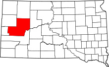 | |
| CDPs |
| |
| Other unincorporated communities | ||
| Indian reservations | ||
| Ghost towns | ||
| Footnotes | ‡This populated place also has portions in an adjacent county or counties | |