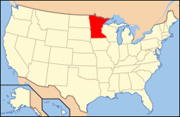
Pill Hill, Rochester, Minnesota
|
Pill Hill | |
|
Several houses from the Historic District | |
  | |
| Location | Rochester, Minnesota |
|---|---|
| Architect | Crawford,Harold; Schwartz,Garfield |
| Architectural style | Colonial Revival, Prairie School, Tudor Revival |
| NRHP Reference # | 85003768 [1] |
| Added to NRHP | November 29, 1990 |
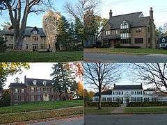
Pill Hill is a National Register of Historic Places district southwest of downtown Rochester, Minnesota. The neighborhood encompasses many old houses built on a limestone bluff for staff of the nearby Mayo Clinic, which led to the name.
The boundaries of Pill Hill are roughly 3rd and 9th Streets and 7th and 10th Avenues Southwest. More generally the neighborhood is found between U.S. 52, U.S. 63 (Broadway), Memorial Parkway, and 2nd Street SW. Saint Mary's Hospital is at the bottom of the hill to the north of the district.[2]
In 1990, the neighborhood was added to the National Register of Historic Places. Several buildings on Pill Hill are individually listed, including the Plummer House and the Mayo Foundation House.
References
- ↑ National Park Service (2007-01-23). "National Register Information System". National Register of Historic Places. National Park Service.
- ↑ NRHP listing
Coordinates: 44°01′01″N 92°28′31″W / 44.01694°N 92.47528°W