Pinconning, Michigan
| Pinconning, Michigan | |
|---|---|
| City | |
| Nickname(s): Pinny, Cheesetown | |
| Motto: Cheese Capital of Michigan | |
 Pinconning, Michigan Location of Pinconning, Michigan | |
| Coordinates: 43°51′18″N 83°57′47″W / 43.85500°N 83.96306°W | |
| Country | United States |
| State | Michigan |
| County | Bay |
| Incorporated (village) | 1872 |
| Re-incorporated (city) | 1935 |
| Government | |
| • Type | Council-Manager |
| • Mayor | Robert Hall |
| • City Manager | Richard Byrne |
| Area[1] | |
| • Total | 0.85 sq mi (2.20 km2) |
| • Land | 0.85 sq mi (2.20 km2) |
| • Water | 0 sq mi (0 km2) |
| Elevation | 600 ft (183 m) |
| Population (2010)[2] | |
| • Total | 1,307 |
| • Estimate (2012[3]) | 1,293 |
| • Density | 1,537.6/sq mi (593.7/km2) |
| Time zone | Eastern (EST) (UTC-5) |
| • Summer (DST) | EDT (UTC-4) |
| ZIP code | 48650 |
| Area code(s) | 989 |
| FIPS code | 26-64160[4] |
| GNIS feature ID | 0634899[5] |
Pinconning is a city in Bay County in the U.S. state of Michigan. The population was 1,307 at the 2010 Census. It is included in the Bay City, Michigan Metropolitan Statistical Area.
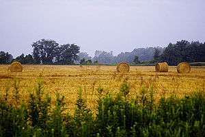
The city is locally noted for production of cheese products, especially Pinconning cheese.
History
The post office in Pinconning opened on January 29, 1873.[6]
Geography
According to the United States Census Bureau, the city has a total area of 0.85 square miles (2.20 km2), all land.[1] The Pinconning River flows through the city.[7]
Demographics
| Historical population | |||
|---|---|---|---|
| Census | Pop. | %± | |
| 1880 | 300 | — | |
| 1890 | 885 | 195.0% | |
| 1900 | 729 | −17.6% | |
| 1910 | 677 | −7.1% | |
| 1920 | 769 | 13.6% | |
| 1930 | 826 | 7.4% | |
| 1940 | 1,027 | 24.3% | |
| 1950 | 1,223 | 19.1% | |
| 1960 | 1,329 | 8.7% | |
| 1970 | 1,320 | −0.7% | |
| 1980 | 1,430 | 8.3% | |
| 1990 | 1,291 | −9.7% | |
| 2000 | 1,386 | 7.4% | |
| 2010 | 1,307 | −5.7% | |
| Est. 2015 | 1,271 | [8] | −2.8% |
2010 census
As of the census[2] of 2010, there were 1,307 people, 580 households, and 324 families residing in the city. The population density was 1,537.6 inhabitants per square mile (593.7/km2). There were 637 housing units at an average density of 749.4 per square mile (289.3/km2). The racial makeup of the city was 96.5% White, 0.7% African American, 0.2% Native American, 0.3% Asian, 0.3% from other races, and 2.1% from two or more races. Hispanic or Latino of any race were 3.6% of the population.
There were 580 households of which 31.0% had children under the age of 18 living with them, 33.6% were married couples living together, 16.6% had a female householder with no husband present, 5.7% had a male householder with no wife present, and 44.1% were non-families. 38.1% of all households were made up of individuals and 18.2% had someone living alone who was 65 years of age or older. The average household size was 2.24 and the average family size was 2.99.
The median age in the city was 37.1 years. 25.4% of residents were under the age of 18; 9.9% were between the ages of 18 and 24; 23.9% were from 25 to 44; 24.7% were from 45 to 64; and 16.1% were 65 years of age or older. The gender makeup of the city was 47.3% male and 52.7% female.
2000 census
As of the census[4] of 2000, there were 1,386 people, 609 households, and 356 families residing in the city. The population density was 1,594.9 per square mile (615.1/km²). There were 645 housing units at an average density of 742.2 per square mile (286.2/km²). The racial makeup of the city was 97.40% White, 0.07% African American, 0.94% Native American, 0.07% Asian, 0.43% from other races, and 1.08% from two or more races. Hispanic or Latino of any race were 3.25% of the population.
There were 609 households out of which 29.4% had children under the age of 18 living with them, 39.2% were married couples living together, 14.9% had a female householder with no husband present, and 41.5% were non-families. 36.0% of all households were made up of individuals and 19.7% had someone living alone who was 65 years of age or older. The average household size was 2.26 and the average family size was 2.93.
In the city the population was spread out with 24.8% under the age of 18, 10.6% from 18 to 24, 26.8% from 25 to 44, 19.7% from 45 to 64, and 18.1% who were 65 years of age or older. The median age was 36 years. For every 100 females there were 87.0 males. For every 100 females age 18 and over, there were 81.5 males.
The median income for a household in the city was $27,188, and the median income for a family was $33,646. Males had a median income of $32,344 versus $21,250 for females. The per capita income for the city was $16,210. About 15.0% of families and 15.9% of the population were below the poverty line, including 20.9% of those under age 18 and 8.8% of those age 65 or over.
Government
The city is within the Pinconning Area School District.
Transportation
Bus
- Indian Trails provides daily intercity bus service between St. Ignace and Bay City, Michigan.[10]
Highways
Lore
The name, "Pinconning," purportedly comes from a local Indian phrase, "o-pin-nic-con-ing," which translates into English as, "potato place."[11] However, there is an alternate interpretation, as "little potato."[12] Both come from the many small, wild potatoes that grow in the region along the Saginaw Bay.
See also
- Bay County Library System, which includes the public library in Pinconning.
- A 1947 Kaiser K100 Special Sedan is known as a "Pinconning Special" and one is located at the National Automobile Museum, in Reno, Nevada.
References
- 1 2 "US Gazetteer files 2010". United States Census Bureau. Archived from the original on January 24, 2012. Retrieved 2012-11-25.
- 1 2 "American FactFinder". United States Census Bureau. Retrieved 2012-11-25.
- ↑ "Population Estimates". United States Census Bureau. Archived from the original on June 17, 2013. Retrieved 2013-06-03.
- 1 2 "American FactFinder". United States Census Bureau. Retrieved 2008-01-31.
- ↑ U.S. Geological Survey Geographic Names Information System: Pinconning, Michigan
- ↑ U.S. Geological Survey Geographic Names Information System: Pinconning Post Office, Michigan
Citation: directoriesUSA. Michigan Business Directory, 2007/2008. 2007/2008. 12-Dec-2007. - ↑ The National Map, accessed 2015-08-21
- ↑ "Annual Estimates of the Resident Population for Incorporated Places: April 1, 2010 to July 1, 2015". Retrieved July 2, 2016.
- ↑ "Census of Population and Housing". Census.gov. Archived from the original on May 11, 2015. Retrieved June 4, 2015.
- ↑ "BAY CITY-ALPENA-CHEBOYGAN-ST. IGNACE" (PDF). Indian Trails. March 19, 2013. Retrieved 2013-04-03.
- ↑ Pinconning Township Main Page http://bjmi.us/bay/pinconning/index.html
- ↑ Pinconning Facebook Page https://www.facebook.com/pages/Pinconning-MI/Pinconning/53074576243
External links
Municipalities and communities of Bay County, Michigan, United States | ||
|---|---|---|
| Cities | 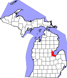 | |
| Charter townships | ||
| General law townships | ||
| Unincorporated communities |
| |
| Footnotes | ‡This populated place also has portions in an adjacent county or counties | |
Coordinates: 43°51′13″N 83°57′54″W / 43.85361°N 83.96500°W