Pingo
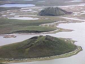

A pingo, also called a hydrolaccolith, is a mound of earth-covered ice found in the Arctic and subarctic that can reach up to 70 metres (230 ft) in height and up to 600 m (2,000 ft) in diameter. The term originated as the Inuvialuktun word for a small hill. The plural form is "pingos".
A pingo is a periglacial landform, which is defined as a nonglacial landform or process linked to colder climates. "Periglacial" suggests an environment located on the margin of past glaciers. However, freeze and thaw cycles influence landscapes outside areas of past glaciation. Therefore, periglacial environments are anywhere that freezing and thawing modify the landscape in a significant manner.[1] They are essentially formed by ground ice which develops during the winter months as temperatures fall.[2][3][4]
Formation
Pingos can only form in a permafrost environment. Evidence of collapsed pingos in an area suggests that there was once permafrost.
Hydrostatic (closed-system) pingos form as a result of hydrostatic pressure on water from permafrost, and commonly form in drained lakes or river channels. Permafrost rises to the drained body's former floor. Pore water is expelled in front of the rising permafrost, and the resulting pressure causes the frozen ground to rise and an ice core to form. The shape and size of a hydrostatic or closed system pingo is often similar to the body of water that it originated from. They can vary from symmetrical conical domes to asymmetric, elongate hills.
Hydraulic (open-system) pingos result from groundwater flowing from an outside source, i.e. subpermafrost or intrapermafrost aquifers. Hydrostatic pressure initializes the formation of the ice core as water is pushed up and subsequently freezes. Open-system pingos have no limitations to the amount of water available unless the aquifers freeze. They often occur at the base of slopes and are commonly known as Greenland type. The groundwater is put under artesian pressure and forces the ground up as it makes an expanding ice core. It is not the artesian pressure itself that forces the ground up, but rather the ice core that is being fed the water from the aquifer. These are often formed in a thin, discontinuous permafrost. These conditions allow an ice core to form, but also provide it with a supply of artesian ground water. If water pressure entering an artesian pingo is strong enough, it can lift the pingo up allowing a sub-pingo water lens to form underneath. However, if the water lens starts to leak water it can cause subsidence which can compromise the structure.[5] These pingos are often oval or oblong shaped. It is still not entirely understood why open system or hydraulic pingos normally occur in unglaciated terrain.
Pingos usually grow only a couple centimetres per year, with Ibyuk Pingo growing at a rate of 2 centimetres (0.79 in) a year,[6] and the largest take decades or even centuries to form. The process that creates pingos is believed to be closely related to frost heaving. The base of the pingo tends to reach its maximum diameter in its early youth. This means pingos tend to grow higher rather than growing in diameter and height at the same time.[5]
Locations
Tuktoyaktuk in the Mackenzie Delta of the Northwest Territories has one of the highest concentrations of pingos, with some 1,350 examples. Pingo National Landmark protects eight of these features.[6] Alaska is home to the Kadleroshilik Pingo, the highest known pingo in the world.[7] Other places with pingos include Nunavut[8] and Yukon in Canada, Greenland, Siberia, and the Norwegian island of Spitsbergen.[2] Recent estimates indicate that more than 11,000 pingos exist on Earth, with more than 6,000 alone in northern Asia.[9]
Some old pingo ruins can be found in Norfolk, England (in the Breckland) and in the Netherlands, in Dantumadeel and Opsterland in the province of Friesland, and also in the provinces of Drenthe[10] and Groningen. Further east remnants of a Pleistocene pingo have been identified in near Moscow.[11]
In Siberia, pingos are known as bulgunniakh, from the Sakha language (Yakut language).[12]
Types
Rounded tops are common for smaller pingos, but larger ones often have breaks in the ice at the top. These larger pingos can have craters that have cones resembling those of volcanoes. This is due to the ice breaking and to melting of the inner ice core. Beds will often dip outward from the center when they occur in stratified sand or silt, a lot like being adjacent to an intrusive body. Pingos that form in bedrock can show similar deformation. The ice in the core of pingos usually originates from segregation or injection of fluid water, and can be massive. Tension fractures are normal for the mound's summit, but pingo ice expansion is brief and rare. A small freshwater lake can occupy the summit where a crater has formed from the ice melting.
Pingos are generally classified as hydrostatic (closed-system) or hydraulic (open-system). Relict hydrostatic (closed-system) and hydraulic (open-system) pingos may be distinguished from each other by determining whether lacustrine (lake) deposits are associated with the formation. Pingos in northern Alaska and northwestern Canada have been found to form in two different environments. Pingos that form on slopes are usually small, irregularly shaped, and fractured at the top. These usually form because of sub-surface hydraulic pressure. Pingos in these areas also form in the more common way, on flat ground in old lake basins when the water is too shallow to prevent permafrost. These structures tend to be much larger than the pingos that form on slopes.[13]
History
The term pingo was first borrowed from the Inuvialuit by the Arctic botanist Alf Erling Porsild in 1938. Porsild Pingo in Tuktoyaktuk is named in his honor.[14]
See also
- Frost heaving
- Palsa, a low oval elevation in areas with permafrost, frequently peat bogs, where a perennial ice lens has developed within the soil.
- Talik
References
- ↑ Pidwirny, M (2006). "Periglacial Processes and Landforms". Fundamentals of Physical Geography.
- 1 2 Pingos Jennifer Vinck, Geology 495, University of Regina, 2006
- ↑ Hydrogeology
- ↑ Periglacial Landforms 1
- 1 2 Mackay, Ross. "Pingos of the Tuktoyaktuk Peninsula Area, Northwest Territories". Department of Geography University of British Columbia.
- 1 2 Pingo Canadian Landmark
- ↑ Mackay, J. Ross (1998). "Pingo Growth and Collapse, Tuktoyaktuk Peninsula Area, Western Arctic Coast, Canada: A Long-Term Field Study" (PDF). Géographie physique et Quaternaire. University of Montreal. 52 (3): 311. doi:10.7202/004847ar. Retrieved 23 June 2012.
- ↑ A Pingo in the Mala River Valley, Baffin Island, Northwest Territories, Canada
- ↑ Grosse, G.; Jones, B.M. (2011). "Spatial distribution of pingos in northern Asia". The Cryosphere. 5: 13–33. Bibcode:2011TCry....5...13G. doi:10.5194/tc-5-13-2011.
- ↑ A.H. Lanting, IVEM, University of Groningen, 2009
- ↑ Pleistocene Pingo in the Central Part of the East European Plain
- ↑ The Canadian Encyclopedia
- ↑ Holmes, William. "Pingos in Central Alaska" (PDF). United States Government Printing Office.
- ↑ The Birth and Growth of Porsild 1 Pingo, Tuktoyaktuk Peninsula, District of Mackenzie
Bibliography
- Easterbrook, Don and O'Neill, W. Scott. (1999) Surface Processes and Landforms. Second Edition. 1999, 1993. Prentice-Hall, inc. p. 412-416.
- Burr, Devon M.; Kenneth L. Tanaka; Kenji Yoshikawa (2009). "Pingos on Earth and Mars". Planetary and Space Science. 57 (5-6): 541–555. Bibcode:2009P&SS...57..541B. doi:10.1016/j.pss.2008.11.003. ISSN 0032-0633. Retrieved 2010-12-29.
External links
| Look up pingo in Wiktionary, the free dictionary. |
- National Snow and Ice Data Center (NSIDC). "All about frozen ground: How does it affect land?". Retrieved 2010-12-29.