Pomeroy, Ohio
| Pomeroy, Ohio | |
|---|---|
| Village | |
|
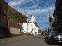
Second Street downtown, with the courthouse in the middle | |
 Location of Pomeroy, Ohio | |
| Coordinates: 39°1′41″N 82°1′55″W / 39.02806°N 82.03194°WCoordinates: 39°1′41″N 82°1′55″W / 39.02806°N 82.03194°W | |
| Country | United States |
| State | Ohio |
| County | Meigs |
| Township | Salisbury |
| Area[1] | |
| • Total | 3.31 sq mi (8.57 km2) |
| • Land | 3.25 sq mi (8.42 km2) |
| • Water | 0.06 sq mi (0.16 km2) |
| Elevation[2] | 571 ft (174 m) |
| Population (2010)[3] | |
| • Total | 1,852 |
| • Estimate (2012[4]) | 1,845 |
| • Density | 569.8/sq mi (220.0/km2) |
| Time zone | Eastern (EST) (UTC-5) |
| • Summer (DST) | EDT (UTC-4) |
| ZIP code | 45769 |
| Area code(s) | 740 |
| FIPS code | 39-64024[5] |
| GNIS feature ID | 1061563[2] |
Pomeroy is a village in and the county seat of Meigs County, Ohio, United States,[6] along the Ohio River. The population was 1,852 at the 2010 census.
History
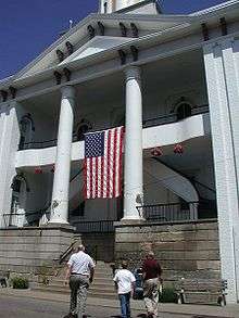
Pomeroy was founded in 1804 and named for landowner Samuel Pomeroy. The village was incorporated in 1840, and designated county seat in 1841.[7]
During the late 19th century, Pomeroy was an important producer of coal and salt. The first coal barges on the Ohio River were loaded there.
The Pomeroy, Ohio McDonald's location is one of only two McDonald's locations in the world still serving pizza. McDonald's abandoned selling pizzas at the stores in the late 90's.[8]
Geography
Pomeroy is located at 39°1′41″N 82°1′55″W / 39.02806°N 82.03194°W (39.028192, −82.031866).[9]
According to the United States Census Bureau, the village has a total area of 3.31 square miles (8.57 km2), of which 3.25 square miles (8.42 km2) is land and 0.06 square miles (0.16 km2) is water.[1]
Demographics
| Historical population | |||
|---|---|---|---|
| Census | Pop. | %± | |
| 1840 | 388 | — | |
| 1850 | 1,638 | 322.2% | |
| 1860 | 6,480 | 295.6% | |
| 1870 | 5,824 | −10.1% | |
| 1880 | 5,560 | −4.5% | |
| 1890 | 4,726 | −15.0% | |
| 1900 | 4,639 | −1.8% | |
| 1910 | 4,023 | −13.3% | |
| 1920 | 4,294 | 6.7% | |
| 1930 | 3,563 | −17.0% | |
| 1940 | 3,581 | 0.5% | |
| 1950 | 3,656 | 2.1% | |
| 1960 | 3,345 | −8.5% | |
| 1970 | 2,672 | −20.1% | |
| 1980 | 2,728 | 2.1% | |
| 1990 | 2,259 | −17.2% | |
| 2000 | 1,966 | −13.0% | |
| 2010 | 1,852 | −5.8% | |
| Est. 2015 | 1,821 | [10] | −1.7% |
2010 census
As of the census[3] of 2010, there were 1,852 people, 757 households, and 483 families residing in the village. The population density was 569.8 inhabitants per square mile (220.0/km2). There were 933 housing units at an average density of 287.1 per square mile (110.8/km2). The racial makeup of the village was 94.3% White, 2.7% African American, 0.5% Native American, 0.1% Asian, and 2.3% from two or more races. Hispanic or Latino of any race were 0.5% of the population.
There were 757 households of which 34.6% had children under the age of 18 living with them, 37.0% were married couples living together, 20.2% had a female householder with no husband present, 6.6% had a male householder with no wife present, and 36.2% were non-families. 29.1% of all households were made up of individuals and 12.8% had someone living alone who was 65 years of age or older. The average household size was 2.44 and the average family size was 2.99.
The median age in the village was 35.2 years. 27% of residents were under the age of 18; 10.5% were between the ages of 18 and 24; 23.8% were from 25 to 44; 25.1% were from 45 to 64; and 13.4% were 65 years of age or older. The gender makeup of the village was 45.8% male and 54.2% female.
2000 census
As of the census[5] of 2000, there were 1,966 people, 835 households, and 516 families residing in the village. The population density was 607.5 people per square mile (234.3/km2). There were 1,041 housing units at an average density of 321.7 per square mile (124.1/km2). The racial makeup of the village was 94.91% White, 2.14% African American, 0.41% Native American, 0.10% Asian, 0.10% from other races, and 2.34% from two or more races. Hispanic or Latino of any race were 0.25% of the population.
There were 835 households out of which 30.8% had children under the age of 18 living with them, 38.3% were married couples living together, 17.6% had a female householder with no husband present, and 38.1% were non-families. 34.5% of all households were made up of individuals and 16.4% had someone living alone who was 65 years of age or older. The average household size was 2.32 and the average family size was 2.95.
In the village the population was spread out with 25.4% under the age of 18, 10.6% from 18 to 24, 26.7% from 25 to 44, 21.2% from 45 to 64, and 16.2% who were 65 years of age or older. The median age was 36 years. For every 100 females there were 78.2 males. For every 100 females age 18 and over, there were 78.5 males.
The median income for a household in the village was $19,971, and the median income for a family was $22,406. Males had a median income of $30,625 versus $20,093 for females. The per capita income for the village was $11,305. About 35.4% of families and 39.2% of the population were below the poverty line, including 61.8% of those under age 18 and 18.7% of those age 65 or over.
Education
Public education in the village of Pomeroy is provided by the Meigs Local School District. Campuses serving the village include Meigs Primary School (Grades K-2), Meigs Intermediate School (Grades 3–5), Meigs Middle School (Grades 6–8), and Meigs High School (Grades 9–12).
Notable people
Jordan Bradford notable author, speaker, preacher, singer, pastor, philanthropist and community leader. Lead Pastor of The Refuge Church. Www.BradfordMinistries.net
- James Edwin Campbell, a poet, writer and educator
- Norman "Kid" Elberfeld, a Major League Baseball shortstop and manager
- Samuel Dana Horton, a bimetallism writer
- Valentine B. Horton, U.S. Representative during the first two years of the American Civil War
- Reverend Fr. John Joseph Jessing, founder of the Pontifical College Josephinum in Columbus, Ohio
- Benny Kauff, Major League Baseball player
- Art Lewis, an NFL player and coach
- Cy Morgan, a Major League Baseball pitcher
- Tobias A. Plants, U.S. Representative, and publisher of Pomeroy Weekly Telegraph
- Livia Simpson Poffenbarger, newspaper owner/editor, civic leader
- Charlie Slack, NCAA basketball record holder for single season rebounding average
- Ambrose Bierce,American journalist, short story writer, editorialist,fabulist and satirist.
See also
References
- 1 2 "US Gazetteer files 2010". United States Census Bureau. Retrieved 2013-01-06.
- 1 2 "US Board on Geographic Names". United States Geological Survey. 2007-10-25. Retrieved 2008-01-31.
- 1 2 "American FactFinder". United States Census Bureau. Retrieved 2013-01-06.
- ↑ "Population Estimates". United States Census Bureau. Retrieved 2013-06-17.
- 1 2 "American FactFinder". United States Census Bureau. Retrieved 2008-01-31.
- ↑ "Find a County". National Association of Counties. Retrieved 2011-06-07.
- ↑ Hellmann, Paul T. (May 13, 2013). "Historical Gazetteer of the United States". Routledge. p. 870. Retrieved November 30, 2013.
- ↑ http://www.eater.com/2015/1/21/7868791/mcdonalds-is-still-serving-pizza-at-exactly-two-locations
- ↑ "US Gazetteer files: 2010, 2000, and 1990". United States Census Bureau. 2011-02-12. Retrieved 2011-04-23.
- ↑ "Annual Estimates of the Resident Population for Incorporated Places: April 1, 2010 to July 1, 2015". Retrieved July 2, 2016.
- ↑ "Census of Population and Housing". Census.gov. Retrieved June 4, 2015.
External links
-
 Chisholm, Hugh, ed. (1911). "Pomeroy". Encyclopædia Britannica (11th ed.). Cambridge University Press.
Municipalities and communities of Meigs County, Ohio, United States | ||
|---|---|---|
| Villages |  | |
| Townships | ||
| CDP | ||
| Unincorporated communities | ||
| Ghost town | ||