Pondosa, California
| Pondosa, California | |
|---|---|
| Unincorporated community | |
 Pondosa, California | |
| Coordinates: 41°11′58″N 121°41′20″W / 41.19944°N 121.68889°WCoordinates: 41°11′58″N 121°41′20″W / 41.19944°N 121.68889°W | |
| Country | United States |
| State | California |
| County | Siskiyou |
| Elevation | 4,140 ft (1,260 m) |
| Time zone | Pacific (PST) (UTC-8) |
| • Summer (DST) | PDT (UTC-7) |
| Area code(s) | 530 |
| GNIS feature ID | 264928[1] |
Pondosa is an unincorporated community in Siskiyou County, California, United States. Pondosa is 33.5 miles (53.9 km) east-southeast of Mount Shasta. A post office opened in Pondosa in 1925. The community was named after the ponderosa pine by Elmer E. Hall.[2]
References
- ↑ U.S. Geological Survey Geographic Names Information System: Pondosa, California
- ↑ Durham, David L. (1998). California's Geographic Names: A Gazetteer of Historic and Modern Names of the State. Quill Driver Books. p. 294. ISBN 1-884995-14-4.
Municipalities and communities of Siskiyou County, California, United States | ||
|---|---|---|
| Cities | 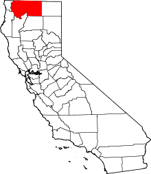 | |
| CDPs | ||
| Unincorporated communities | ||
| Indian reservation | ||
| Ghost towns | ||
| Footnotes | ‡This populated place also has portions in an adjacent county or counties | |
This article is issued from Wikipedia - version of the 10/29/2016. The text is available under the Creative Commons Attribution/Share Alike but additional terms may apply for the media files.