Ponnur
| Ponnur పొన్నూరు | |
|---|---|
| Town | |
 Ponnur Location in Andhra Pradesh, India | |
| Coordinates: 16°04′00″N 80°34′00″E / 16.0667°N 80.5667°ECoordinates: 16°04′00″N 80°34′00″E / 16.0667°N 80.5667°E | |
| Country | India |
| State | Andhra Pradesh |
| District | Guntur |
| Government | |
| • MLA | Dulipala Narendra Kumar |
| Area[1] | |
| • Total | 25.64 km2 (9.90 sq mi) |
| Population (2011)[2] | |
| • Total | 59,913 |
| • Density | 2,300/km2 (6,100/sq mi) |
| Languages | |
| • Official | Telugu |
| Time zone | IST (UTC+5:30) |
| PIN | 522 124 |
| Telephone code | +91–8643 |
| Sex ratio | 1:0.96 ♂/♀ |
| Website |
ponnur |
Ponnur is a town in Guntur district of the Indian state of Andhra Pradesh. It is a municipality and the mandal headquarter of Ponnur mandal under Tenali revenue division.[3][4]
Demographics
As of 2011 Census of India, the town had a population of 59,913 with 16,138 households. The total population constitute, 29,486 males and 30,427 —a sex ratio of 1032 females per 1000 males, higher than the national average of 940 per 1000.[5] 5,507 children are in the age group of 0–6 years. The average literacy rate stands at 78.33% with 42,617 literates, higher than the national average of 73.00%.[2][6]
Government and politics
Civic Administration
Ponnur Municipality oversees the civic needs of the town like, water supply, roads, sewage, garbage collection etc. It is classified as a Grade–II municipality which was established in 1964 as a III–Grade municipality.[7] It has an extent of 25.64 km2 (9.90 sq mi) with 31 wards.[8] The town gets water from the Krishna river, which is supplied through taps, bores etc. The town has both government and private hospitals which include, clinics, nursing homes and a Government hospital for public healthcare. It also maintains parks and play grounds for recreational purpose[9]
Politics
Ponnur being a part of Ponnur mandal, falls under Ponnuru assembly constituency of Andhra Pradesh Legislative Assembly.[10] Dhulipalla Narendra Kumar is the present MLA of the constituency from Telugu Desam Party.[11] The assembly segment is in turn a part of Guntur lok sabha constituency and the present Member of parliament is Galla Jayadev of Telugu Desam Party.[12][13]
Economy
Ponnur is an important town for the nearby villages. The rural areas surrounding the town are mostly dependent on agriculture. The farming is dominant with Paddy cultivation and others crops include ground nuts, cotton, betel etc.[4] There exists several other economic industries and occupations in the town such as, Brickworks, furniture making, handloom weaving, spinning khadi yarn, rice mills, timber etc.[14] The town is also a part of Tenali–Ponnur growth corridor.[15]
Culture
There are a few notable people from the town with their contributions to various fields such as, N. G. Ranga, Pragada Kotaiah. The town has an auditorium and a function hall for cultural events of the town.[9]
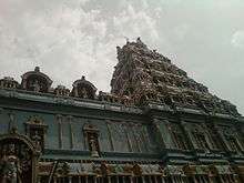
There are many religious worship centers in the town like, temples, mosques and churches.[9] Most notable religious structures are, the temples of Sakshi Bhavanarayana and Sahastra Lingeswara, a single stone carved statues of 24 ft (7.3 m) Anjaneya and 29 ft (8.8 m) Garuthmantha.[4][16]
Transport
State Highway 48, also known as Guntur-Bapatla-Chirala Road passes through Ponnur, which connects it with the district headquarter, Guntur. The Ponnur–Repalle Road connects National Highway 214A at Chandole.[17][18] The state government operates APSRTC nus services to the nearby towns and villages. Nearest railway station is at Nidubrolu,[19] a D–category station in the Vijayawada railway division of South Central Railway zone.[20]
Education
The primary and secondary school education is imparted by government, aided and private schools, under the School Education Department of the state.[21][22] The medium of instruction followed by different schools are English, Telugu.
The town has both government and private educational institutions with a total of 34 primary, 3 upper primary and 12 high schools. There are also two government run junior colleges.[9]
References
- ↑ "Basic Information of Municipality". ponnurmunicipality.com. Retrieved 6 April 2016.
- 1 2 "Census 2011". The Registrar General & Census Commissioner, India. Retrieved 24 August 2014.
- ↑ "District Census Handbook – Guntur" (PDF). Census of India. pp. 14,46. Retrieved 29 February 2016.
- 1 2 3 "Basic Information of Municipality". Commissioner & Director of Municipal Administration. Municipal Administration & Urban Development Department, Govt. of Andhra Pradesh. Retrieved 17 January 2015.
- ↑ "Sex Ratio". The Registrar General & Census Commissioner, India. Retrieved 29 August 2014.
- ↑ "Chapter–3 (Literates and Literacy rate)" (PDF). Registrar General and Census Commissioner of India. Retrieved 24 August 2014.
- ↑ "Basic Information of Municipality". Municipal Administration & Urban Development Department. Government of Andhra Pradesh. Retrieved 17 June 2015.
- ↑ "Municipalities, Municipal Corporations & UDAs" (PDF). Directorate of Town and Country Planning. Government of Andhra Pradesh. Archived from the original (PDF) on 28 January 2016. Retrieved 29 February 2016.
- 1 2 3 4 "Public services/amenities". Commissioner & Director of Municipal Administration. Retrieved 31 March 2016.
- ↑ "Delimitation of Parliamentary and Assembly Constituencies Order, 2008" (pdf). Election Commission of India. p. 22,31. Retrieved 11 October 2014.
- ↑ "MLA". AP State Portal. Retrieved 12 October 2014.
- ↑ "Delimitation of Parliamentary and Assembly Constituencies Order, 2008" (pdf). Election Commission of India. p. 22,31. Retrieved 11 October 2014.
- ↑ "MP (Lok Sabha)". Government of AP. Retrieved 4 May 2015.
- ↑ Sajnani, Manohar (2001). Encyclopaedia of Tourism Resources in India, Volume 2 (Volume 2 ed.). Gyan Publishing House. p. 69. ISBN 978-81-7835-018-9. Retrieved 2 March 2016.
- ↑ "Need to enforce building rules: VGTM-UDA vice-chief". The Hindu. Guntur. 2012-07-14. ISSN 0971-751X. Retrieved 2016-04-05.
- ↑ "Sri Veera Anjaneya Swamy". Guntur district website. National Informatics Centre. Retrieved 1 March 2016.
- ↑ Samuel Jonathan, P (8 October 2015). "Nizampatnam backwaters beckon adventure geeks". The Hindu. Guntur. Retrieved 29 February 2016.
- ↑ "Narrow roads prove to be a bane at Ponnur". The Hindu. Ponnur (Guntur district. 8 June 2012. Retrieved 29 February 2016.}
- ↑ "NDO/Nidubrolu (3 PFs) Railway Station Map/Atlas – India Rail Info". India Rail Info.
- ↑ "Vijayawada division – A Profile" (PDF). South Central Railway. Archived from the original (PDF) on 28 January 2016. Retrieved 29 February 2016.
- ↑ "School Eduvation Department" (PDF). School Education Department, Government of Andhra Pradesh. Retrieved 7 November 2016.
- ↑ "The Department of School Education - Official AP State Government Portal | AP State Portal". www.ap.gov.in. Retrieved 7 November 2016.