Ponta Grossa
| City of Ponta Grossa, Paraná | |||
|---|---|---|---|
| City | |||
|
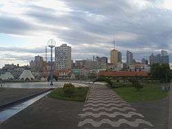
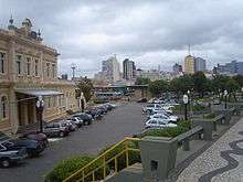
City Landscape | |||
| |||
| Nickname(s): Princesa dos Campos | |||
| Motto: 'Princesa dos Campos'(Princess of the fields) | |||
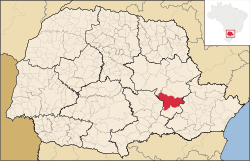 Location of Ponta Grossa | |||
 City of Ponta Grossa, Paraná Location of Ponta Grossa | |||
| Coordinates: 25°25′S 49°15′W / 25.417°S 49.250°W | |||
| Country |
| ||
| Region | South | ||
| State | Paraná | ||
| Founded | 6 December 1855 | ||
| Incorporated | 1842 | ||
| Government | |||
| • Mayor | Marcelo Rangel (PPS) | ||
| Area | |||
| • Total | 2,067.6 km2 (798.65 sq mi) | ||
| Elevation | 975 m (3,199 ft) | ||
| Population (2009)[1] | |||
| • Total | 331,084 | ||
| • Density | 150.55/km2 (388/sq mi) | ||
| Time zone | UTC-3 (UTC-3) | ||
| • Summer (DST) | UTC-2 (UTC-2) | ||
| Area code(s) | 42 | ||
| HDI (2000) | 0.804 – high | ||
| Website | Ponta Grossa, Paraná | ||

Ponta Grossa, Paraná, Brazil is a municipality in the state of Paraná, Brazil. With a population of over 330,000 inhabitants, it is the 4th most populous city of Paraná.
It is the second industrial pole of the State, exceeded only by Curitiba—the State's capital and largest city. Ponta Grossa, also known as the Princesa dos Campos — Princess of the Fields — is the home of the Ponta Grossa State University (UEPG).
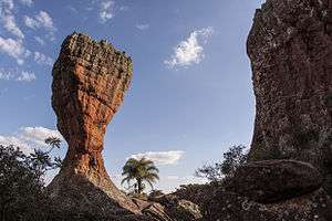
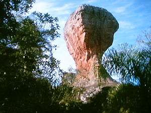
Ponta Grossa is also home town of the "Parque Estadual da Vila Velha" (State Park of Old Town), a park made up of rocky formations formed over millions of years. Each rock formation has its own name, depending on which object/animal they look like.
Another attraction of the city is the Münchenfest – A National Stout Festival with national and international concerts that lasts a whole week and occurs at late November and the beginning of December.
History
Ponta Grossa was founded in 1822, being created in 1823 the "Star Town", its first denomination. In April 1855, the town became a city, being separated from Castro and named Ponta Grossa.
The city in its beginning, in the seventeenth century, was oriented by the geographic location and being a route and stop for the sleeping of "troops", transport of resources and trade between the cities of Viamão (on southern Brazil) and Sorocaba (on center-east). Nowadays, Ponta Grossa has the biggest road and rail complex of the south region of the country.
The city already was the second biggest city in the Paraná State (by early 1900) and was the state capital for five days during Ragamuffin War (Farrapos War).
Population
The population is composed of many different ethnicities. In the earlier days, it was made up of explorers and distinguished families coming mainly from São Paulo. From the beginning of the twentieth century on, numerous Slavic (Russians, Poles and Ukrainians) and German families settled in the city, along with Dutch, Italian, Lebanese and Japanese immigrants. Germans and Slavs are the most numerous ones.
Geography
The area is served by many rivers. Among the most important are: Tibagi, Verde, Pitangui, "Chapada" Creek, as well as the basin of Botuquara, "Rio da Morte", "Terra Vermelha Creek" and "Quebra Perna River".
Climate
The climate is subtropical with mild or warm summers with an average of 21.4 °C (70 °F). The winters are cool with an average of 13 °C (55 °F). Temperature drops below freezing point at least once a year. Year-round average temperature stands at 17 °C (62 °F). All-time extremes were 36 °C and -8 °C.
Limits
To north are the towns of Castro and Carambeí, to south the towns of Palmeira and Teixeira Soares, to east the city of Campo Largo, and Tibagi and Ipiranga to west.
Tourism
Visitors have many tourist attractions, many of them not accessible by public transport.
Attractions
- Old Town State Park (In Portuguese: Parque Estadual de Vila Velha)
- Priest's Hole (pt: Buraco do Padre) and Mariquinha Fall (pt:Cachoeira da Marinquinha) – both private properties. For nautical sports, the tourists and ponta-grossenses have the Alagados, 7,5 miles from the downtown. All these places are considered very pretty and calm for family tour. The access to them are by paved and unpaved roads.
For one day trips, attractions from the region of Campos Gerais are also available. Most notably are Guartela Canyon, on the city of Tibagi, and the Dutch village and its historical mill in Castroland District and the Tropeiro Museum, both in Castro.
The most common adventure sports on the region are climbing/rappelling, on country area of Ponta Grossa – like the stone walls on Mariquinha Fall and Priest's Whole – and slalom/canoeing on the Tibagi River, in the city of Castro
- Historical buildings
From the architectural point of view, the city has an interesting patrimony. Constructions like Vila Hilda Mansion (pt: Mansão Vila Hilda) (actual seat of Culture secretariat), the formers train station Casa da Memória Paraná, Art Station and Longing Station, the Campos Gerais Museum, the Epoch Museum, the Opera Theatre, Planalto Palace Hotel, and more, that take us to 19th century and beginning of 20th century, when the city was the third biggest in the Southern Region.
Some of the religious attractions are the Resurrection Monastery, Rosario Church, Santa Barbara chapel and São José Graveyard. The city also has other old buildings and houses around XV and Vicente Machado Streets. On the 1970s, the city has suffered a boom of modernization on the central area.
New modern and in the forefront constructions are the Santana Cathedral and many private houses.
- Business, tourism and hospitality
The business tourism increased a lot between the 1990s and 2000s with the construction of new hotels, nowadays there are more than 2000 rooms available in Ponta Grossa. For events, the city has large areas such as the City of Ponta Grossa Events Center, Slaviero Hotel Convention Center and Palladium Shopping Mall. Other hotels, like Planalto Palace Hotel and Bristol Vila Velha, offer areas for small and medium size events.
- Cultural attractions and events
Theater and Musical Concerts area regularly available in places such Opera Theater and Marista Theater. There are four movies theaters in the city.
There are also annual events, the main is the National Stout Festival, called Münchenfest, with German typical dances and Concerts with national and international artists. Other events are Grape Festival, Rodeo of Rodeos, Campos Gerais Farming and Cattle Raising Fair, called Efapi, and many others.
Education
The city has two public colleges:
- Ponta Grossa State University (UEPG) (Pt: Universidade Estadual de Ponta Grossa)
- Parana Federal Technological University (UTFPR) (Pt:Universidade Tecnológica Federal do Paraná)
Both institutions attract undergraduate and graduate students from many regions, mostly from the south of Brazil. The city also has private colleges as Faculdades Uniao, Faculdades Santa Amelia (Secal) e Sant'Ana, Centro de Ensino Superior dos Campos Gerais (Cescage) and a campus of Centro Universitário Campos de Andrade (Uniandrade).
Culture
Ponta Grossa is graced with a vast cultural scene. The city has three theaters in perfect conditions of usage, totaling almost 3000 seats, movie theaters, arts gallery and places for visual arts and music expositions and events. The Ponta Grossa State University (UEPG) offers majors in Visual Arts and Music. The city also has its own orchestra, the Ponta Grossa Symphony Orchestra, and the Paulimo Martins Music School.
Museum
- Campos Gerais Museum
- Epoch Museum
- Egyptian Museum
- Casa da Memória Paraná
Theaters
- Opera Theater
- Marista Theater
- Pax Theater
Cinema
- Multiplex Palladium
- Cinema Lumière
Art Galleries
- Culture Center City of Ponta Grossa
- Pinacotheca Cidade de Ponta Grossa
Public administration
The government of the municipality following the determination of Brazil's Constitution: Executive, headed by the mayor and his secretariat, and the legislative branch, represented by the City Council.
The executive is elected for four years with the possibility of reelection, and their municipal and local authorities. The secretaries are set by the mayor, usually accommodating party allies of the chief executive. Also belong to the municipality (or is it a majority stake in its social capital) a number of companies responsible for different aspects of public services and the economy.
The Municipality of Ponta Grossa is composed of 14 aldermen (or is it 15) elected to four-year, with the possibility of consecutive reelection for another term (or forever, according to the will of the population). The aldermen are responsible for drafting and adoption of fundamental laws for the administration and the Executive, including the annual budget of the municipality (known as the Budget Guidelines Law). Several special committees, each headed by an alderman, are part of the house of laws such as the Budget, Health, Public Transport, among others. The Council is chaired by a president – which among other functions, sets the voting agenda of the house, and also has vice president and first secretary.
Notable residents
Luiz Dell'Aglio, Aerobatic pilot
Representatives
Mandates 2008–2012 Executive Mayor: Pedro Wosgrau Filho (PSDB) Vice Mayor: Roger Serman (DEM) Legislative Mayor: Sebastião Mainardes Junior (DEM) Councilors (term 2008–2012): Dr. Zeca (PSDB) – the most votes for alderman two legislatures (2004–2008) George (PMN) Dr. Pascoal (PMDB) Mauricio Silva (PSB) Professor Ana Maria (PT) Mainardes (DEM) Lacco (PRP) Crank (PSB) Valtaa (DEM) Julio Kuller (PPS) Alysson Zampieri (PPS) Edilson Fogaça (PTN) Dr. Enoch (PTN) Aline de Almeida (PMDB) Alessandro (PSDB)
Economy
The economy of Ponta Grossa had three great drives during the twentieth century. The first in mid-1900 with the installation of the railway, the second in the 1970s with the installation of large industrial area of food and milling, and the third in the second half of the 1990s with the establishment of large national companies in the logistics sector and production and investment of large networks of the service sector.
The city is close to major consumer markets of Brazil, São Paulo and Curitiba, and is a conduit for the export of goods through the port of Paranaguá and the Hall of Mercosur, the highway that connects the south of Brazil for the Mercosur countries. It is the fourth largest city of Paraná exporter and the tenth South [5] in particular, to Japan and Europe.
Industries
At about ten miles from the center of Ponta Grossa is the Industrial District Ciro Martins. The complex, located next to the Gothic region Sesa, is the largest in the state, behind Curitiba and its metropolitan area. The city has industries in the following areas: the extraction of talc, livestock, agro-industry (particularly soybeans, which gives the town the title Soybean Capital of the World), timber, metals, metals, food, textiles.
Some industrial plants installed in Ponta Grossa are Monofil [2], LP Masisa, Makita, Femsa Brewery, Continental, Tetra Pak, Beaulieu of Brazil, Louis Dreyfus, Cargill, Bunge, Batavia, Sadia, among others especially the food-milling industry. In the Industrial District is also installed is the granary of CONAB (National Supply Company), the largest store of grain in Brazil, with load capacity to 420 tons. In August 2011, Paccar announced it selected a 200 hectare industrial site, to build a 4 hectare facility to build DAF trucks. DAF is a Dutch brand of trucks. The facility will employ about 500 workers directly.[2]
The strategic location ensures proximity to transportation to ports (or even of Paranaguá Santos, airports (London and designed the Campos Gerais) and neighboring countries such as Argentina and Paraguay.
The industrialization process took place in the city during the period between 1975 and 2005 driven by a strong infrastructure of transportation, labor, skilled labor and cheap, with the presence of the Universidade Estadual de Ponta Grossa (PBK), and since 1991, Federal Technological University of Paraná (UTFPR).
Services
Because it is Grand trunk road, Ponta Grossa is known as the capital of the truck, the sector that operates in this area is largely developed and diverse, attracting fleet owners and truck drivers of all parents to make repairs on their vehicles, this sector is concentrated in regions of Av Souza Naves, Av Pres. Kennedy and PR 151.
In the service sector, the city has a large supermarket chains, such as the Big Supermarket (controlled by the giant Wal-Mart), shopping malls, popular fast-food (like McDonald's, Bob's and Burger King) and Habib's already announced, as well as large national stores and regional department, electronics and retail.
The city has one of the highest GDP of Paraná and, paradoxically, has pronounced deficits in infrastructure. Evidence of this are the numbers of IPARDES 2007, indicating that Maringá has a similar population, but with more water supply and sewerage, increased paved area and a smaller number of people in poverty.
According to research conducted by Revista Você S / A, Ponta Grossa is the 84th best city to make a career in Brazil:
- Shopping Malls
- Palladium Shopping Center
- Shopping Total
- Shopping Mitai
- Popular Shopping
- Shopping Antarctica
The city is served by Ponta Grossa Airport.
References
- ↑ "Região Metropolitana" (in Portuguese). Prefeitura Municipal de Curitiba. Retrieved 8 January 2007.
- ↑ http://www.businesswire.com/news/home/20110831006696/en/PACCAR-Selects-DAF-Brasil-Factory-Site
External links
| Wikimedia Commons has media related to Ponta Grossa. |
 Ponta Grossa travel guide from Wikivoyage
Coordinates: 25°05′58″S 50°09′30″W / 25.09944°S 50.15833°W