Presidential Range
| Presidential Range | |
|---|---|
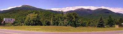 The Presidential Range viewed from Pinkham Notch | |
| Highest point | |
| Peak | Mount Washington |
| Elevation | 6,288 ft (1,917 m) |
| Coordinates | 44°16′14.98″N 71°18′12.54″W / 44.2708278°N 71.3034833°WCoordinates: 44°16′14.98″N 71°18′12.54″W / 44.2708278°N 71.3034833°W |
| Naming | |
| Etymology | U.S. presidents |
| Geography | |
| Country | United States |
| State | New Hampshire |
| Region | New England |
| Parent range | White Mountains |
The Presidential Range is a mountain range located in the White Mountains of the U.S. state of New Hampshire. Containing the highest peaks of the Whites, its most notable summits are named for American presidents, followed by prominent public figures of the 18th and 19th centuries. The Presidential Range is notorious for having some of the worst weather on Earth, mainly because of the unpredictability of high wind speeds and whiteout conditions on the higher summits. Because of the poor weather conditions, the Presidential Range is often used for mountaineering training for those who go on to climb some of the world's highest mountains, including K2 and Everest.
Mt. Washington, long home of the highest winds recorded on the surface of the Earth at 231 mph (372 km/h), is the tallest at 6,288 ft (1,917 m), followed by neighboring peaks Mt. Adams at 5,793 ft (1,766 m) and Mt. Jefferson at 5,712 ft (1,741 m). The range is almost entirely in Coos County.
Notable summits
The highest mountains in the Presidential Range are named principally for U.S. presidents, with the tallest mountain (Mt. Washington) named for the first president, the second tallest (Mt. Adams) for the second president, and so on. However, due to a surveying error, Mt. Monroe is actually 22 feet (6.7 m) taller than Mt. Madison, which is not the correct order of presidents.
Among the range's most notable summits (in sequence from southwest to northeast):
- Mount Webster — after Daniel Webster
- Mt. Jackson* — after Charles Thomas Jackson (19th-century geologist)
- Mt. Pierce* — after Franklin Pierce (formerly Mt. Clinton — after DeWitt Clinton)
- Mt. Eisenhower* — after Dwight D. Eisenhower
- Mt. Franklin — after Benjamin Franklin
- Mt. Monroe* — after James Monroe
- Mt. Washington* — after George Washington (a general at time of naming, and only later a president)
- Mt. Clay — after Henry Clay (State of New Hampshire changed name to Mt. Reagan after Ronald Reagan; U.S. government still recognizes Clay name)
- Mt. Jefferson* — after Thomas Jefferson
- Mt. Sam Adams — after Samuel Adams
- Mt. Adams* — after John Adams
- Mt. Quincy Adams — after John Quincy Adams
- Mt. Madison* — after James Madison
Mt. Adams has four subsidiary peaks besides its summit that are also commonly recognized by name. Two are listed above (Sam Adams and John Quincy Adams). The third and fourth are:
- Mount Abigail Adams (formerly Adams IV)
- Adams V
The summits marked with an asterisk (*) are included on the peak bagging list of 4,000-foot and higher mountains in New Hampshire; the others are excluded, in some cases because of lesser height and in others because of more technical criteria.

Other summits
Aside from the notable summits, the Presidential Range contains a number of additional named peaks. Several of these peaks, drained on their west faces by the Dry River, are less accessible than the main and most-visited ridge of the range.
Subsidiary peaks of Mount Washington:
- Ball Crag (6,106 ft)
- Nelson Crag (5,620 ft)
- Boott Spur (5,500 ft)
North from Mount Washington:
- Mt. Bowman (3,449 ft) (spur of Mount Jefferson)
South from Mount Washington:
- Engine Hill (3,100 ft)
- Maple Mountain (2,601 ft)
- Iron Mountain (2,726 ft)
- Montalban Ridge:
- Mt. Isolation (4,004 ft)*
- Mt. Davis (3,819 ft)
- Stairs Mountain (3,463 ft)
- Mt. Resolution (3,415 ft)
- Bemis Ridge:
- Mt. Crawford (3,119 ft)
- Mt. Hope (2,505 ft)
- Mt. Parker (3,004 ft)
- Mt. Langdon (2,390 ft)
- Mt. Pickering (1,945 ft) (family name of first president of Appalachian Mountain Club)
- Mt. Stanton (1,716 ft)
The summits marked with an asterisk (*) are included on the peak-bagging list of 4,000-foot and higher mountains in New Hampshire; the others are excluded, in some cases because of lesser height and in others because of more technical criteria.
Watersheds
The Presidentials separate drainage via the Saco and Androscoggin rivers into the Atlantic Ocean on the coast of Maine, from drainage into the Israel and Ammonoosuc rivers, thence into the Connecticut River, and thence into Long Island Sound.
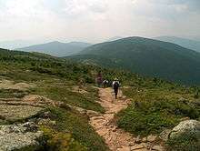
Presidential Traverse
The so-called Presidential Traverse is a hike that traverses each major summit along the 19 miles (31 km) of the Presidential ridge. The traverse encompasses over 8,500 feet (2,600 m) in elevation gain. It can be done in a single day in summer, but during winter it is generally a two- to four-day venture. The traverse is considered strenuous.[1]
References
- ↑ "Presidential Traverse FAQ". Peakbagging the 4000 Footer Mountains of New England. Retrieved October 23, 2013.