White Mountains (New Hampshire)
| White Mountains | |
|---|---|
|
| |
| Highest point | |
| Peak | Mount Washington |
| Elevation | 6,288 ft (1,917 m) |
| Coordinates | 44°16′15″N 71°18′12.5″W / 44.27083°N 71.303472°W |
| Geography | |
| Country | United States |
| States | New Hampshire and Maine |
| Region | New England |
| Range coordinates | 44°16′N 71°19′W / 44.27°N 71.31°WCoordinates: 44°16′N 71°19′W / 44.27°N 71.31°W |
| Parent range | Appalachian Mountains |
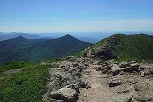
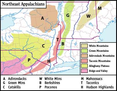
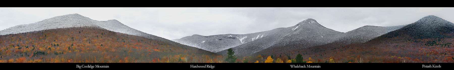
The White Mountains are a mountain range covering about a quarter of the state of New Hampshire and a small portion of western Maine in the United States. They are part of the northern Appalachian Mountains and the most rugged mountains in New England. The range is heavily visited due to its proximity to Boston and, to a lesser extent, New York City and Montreal.
Most of the area is public land, including the White Mountain National Forest and a number of state parks. Its most famous mountain is 6,288-foot (1,917 m) Mount Washington, which is the highest peak in the Northeastern U.S. and which held the record for fastest surface wind gust (231 miles per hour (372 km/h), over 100 m/s, in 1934) in the world for 76 years. Mount Washington is part of a line of summits, the Presidential Range, that are named after U.S. presidents and other prominent Americans.
The White Mountains also include the Franconia Range, Sandwich Range, Carter-Moriah Range and Kinsman Range in New Hampshire, and the Mahoosuc Range straddling the border between it and Maine. In all, there are 48 peaks within New Hampshire as well as one (Old Speck Mountain) in Maine over 4,000 feet (1,200 m), known as the Four-thousand footers.
The Whites are known for a system of alpine huts for hikers operated by the Appalachian Mountain Club. The Appalachian Trail crosses the area from southwest to northeast.
Origin of name
It is not clear where the name "White Mountains" came from. There is no record of what Native Americans called the range, although pre-Colonial names for many individual peaks are known.[1] The name and similar ones such as "White Hills" or "Wine Hills" are found in literature from Colonial times. According to tradition, the mountains were first sighted from shipboard off the coast near the Piscataqua estuary. The highest peaks would often be snow-capped, appearing white. An alternate theory is that the mica-laden granite of the summits looked white to observers.
Geology and physiography
The White Mountains are a physiographic section of the larger New England province, which in turn is part of the larger Appalachian physiographic division.[2]
The magma intrusions forming the White Mountains today were created 124 to 100 million years ago as the North American Plate moved westward over the New England hotspot.
Widespread evidence of glaciation may be seen in the U-shaped form of various notches, or mountain passes. Glacial cirques form the heads of Tuckerman Ravine on Mt. Washington and King Ravine on Mt. Adams. Glacial striations are visible at numerous locations, including on the exposed rocks at the summit of Pine Mountain in Gorham.
Attractions

The Mount Washington Auto Road and the historic Mount Washington Cog Railway ascend the range's highest peak. Heavily visited Arethusa Falls, the second tallest waterfall in New Hampshire, lies on a southwest flank of Crawford Notch. The Old Man of the Mountain, a rock formation on Cannon Mountain that resembled the craggy profile of a man's face, was a White Mountain landmark until it fell in May 2003. It remains the state symbol of New Hampshire. The range also includes a natural feature dubbed "The Basin", consisting of a granite bowl, 20 feet (6 m) in diameter, fed by a waterfall, worn smooth by the Pemigewasset River. The areas around The Basin are popular spots for swimming in the ice-cold mountain-fed water.
The range is crossed north–south by U.S. Route 3 and Interstate 93 through Franconia Notch and New Hampshire Route 16 through Pinkham Notch, and east–west by the Kancamagus Highway (part of New Hampshire Route 112) through Kancamagus Pass and U.S. Route 302 through Crawford Notch.
Mapping
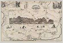
Some of the earliest maps of the White Mountains were produced as tourist maps and not topographical maps. One of the first two tourist maps of the mountains was that produced by Franklin Leavitt, a self-taught artist born near Lancaster, New Hampshire in 1824.[3] Leavitt's hand-drawn map, today in the collection of Harvard University, is largely folk art, but does convey some of the region's features.[4] Leavitt drew several versions of his map, beginning in 1852. The fourth version, printed in 1871, was printed at Boston and carried a retail price of one dollar.[5] Other early maps of the region were drawn by H. Conant and by Harvard astronomer George Phillips Bond, who published the first topographical map of the region in 1853.[6]
Art
As the most ruggedly picturesque area in the northeast U.S., the White Mountains drew hundreds of painters during the 19th century. This group of artists is sometimes referred to as belonging to the "White Mountain school" of art. Others dispute the notion that these painters were a "school", since they did not all paint in the same style as, for example, those artists of the Hudson River School.
In literature and drama
Nathaniel Hawthorne chose the White Mountains as the setting for his short story, "The Great Carbuncle". Other White Mountain tales by Hawthorne include "The Ambitious Guest", "Sketches from Memory" and "The Great Stone Face". The White Mountain region also figures prominently in the writings of Louisa May Alcott, including the novel Eight Cousins and its sequel, Rose in Bloom.
In the final two episodes of Breaking Bad, Walter White hides out in the fictional Crawford County within the White Mountains. The county's name perhaps refers to the real-life Crawford Notch.
See also
- Four-thousand footers
- High Huts of the White Mountains
- List of mountain passes in New Hampshire
- List of mountains in New Hampshire
- White Mountains Region
References
- ↑ AMC: "How the White Mountains Were Named"
- ↑ "Physiographic divisions of the conterminous U. S.". U.S. Geological Survey. Retrieved 2007-12-06.
- ↑ Franklin Leavitt, Map of the White Mountains, New Hampshire, WhiteMountainHistory.org
- ↑ Franklin Leavitt White Mountains Map, Harvard University
- ↑ 1871 Franklin Leavitt Map, WhiteMountainHistory.org
- ↑ George P. Bond: Map of the White Mountains of New Hampshire, WhiteMountainHistory.org
External links
| Wikimedia Commons has media related to White Mountains (New Hampshire). |
- The Grand Hotels, The Glory and The Conflagration, Randall E. Spalding, WhiteMountainHistory.org
-
 "White Mountains". The American Cyclopædia. 1879.