Saco River
| Saco River | |
|---|---|
|
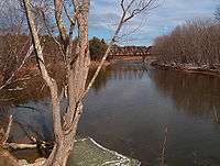
The Saco River in Conway, New Hampshire | |
| Country | United States |
| Basin | |
| Main source | Saco Lake, White Mountains |
| River mouth | Gulf of Maine, North Atlantic Ocean |
| Basin size | 1,293 sq mi (3,350 km2) |
| Physical characteristics | |
| Length | 136 miles (219 km) |
Coordinates: 43°27′40″N 70°22′37″W / 43.46111°N 70.37694°W
The Saco River is a river in northeastern New Hampshire and southwestern Maine in the United States. It drains a rural area of 1,703 square miles (4,410 km2) of forests and farmlands west and southwest of Portland, emptying into the Atlantic Ocean at Saco Bay, 136 miles (219 km) from its source.[1] It supplies drinking water to roughly 250,000 people in thirty-five towns; and historically provided transportation and water power encouraging development of the cities of Biddeford and Saco and the towns of Fryeburg and Hiram.[2] The name "Saco" comes from the Eastern Abenaki word [sɑkohki], meaning "land where the river comes out".[3] The Jesuit Relations, ethnographic documents from the 17th century, refer to the river as Chouacoet.[4]
Course

The river rises at Saco Lake in Crawford Notch in the White Mountains and flows generally south-southeast through Bartlett and Conway in Carroll County, New Hampshire before crossing into Oxford County, Maine.
Shortly after entering Fryeburg, Maine, the river branches into the "Old Course" Saco River and the more commonly used "Canal River". Constructed in the 1800s to be more convenient for farmers, the 6-mile (10 km) long canal is 15 miles (24 km) shorter than the old course[5] and is now considered to be the official course for the river, as the upstream end of the old course is largely silted over. The two channels merge again near Lovell, Maine.
After running through six hydropower stations operated by NextEra Energy Resources (including Skelton Dam and Bonny Eagle Dam), the river enters York County, crosses under Interstate 95, and passes between Saco and Biddeford, where it is bridged by U.S. Route 1. It enters Saco Bay on the Atlantic with Camp Ellis in Saco on the north shore and Hills Beach in Biddeford on the south shore.
Stream flow
The United States government maintains two stream gauges on the Saco river. The first is at Conway, New Hampshire (43°59′27″N 71°05′29″W / 43.99083°N 71.09139°W) where the river's watershed is 385 square miles (997 km2). Discharge (stream flow) here averages 962 cubic feet per second (27.2 m3/s) and has ranged from a minimum of 40 cubic feet per second (1.1 m3/s) to a maximum of 47,200 cubic feet per second (1,340 m3/s).[6] The second is at Cornish, Maine (43°48′29″N 70°46′53″W / 43.80806°N 70.78139°W) where the watershed is 1,293 square miles (3,350 km2). Flow here averages 2,756 cubic feet per second (78.0 m3/s) and has ranged from a minimum of 244 cubic feet per second (6.9 m3/s) to a maximum of 46,600 cubic feet per second (1,320 m3/s).[7]
Attractions
The Saco is a popular recreational river, drawing an estimated 3,000 to 7,000 people per summer weekend, mostly on the stretch from Swan's Falls (a campground formerly maintained by the Appalachian Mountain Club and now maintained by the Saco River Recreation Council), to Brownfield, Maine.
There are many sand beaches along the Saco when not at flood stage and camping is allowed along some of these beaches for free. Misuse, including large quantities of garbage left behind by users and illegal fires, as well as discourtesy toward landowners, has led many beaches to be posted and monitored. A permit is required from the State of Maine for campfires along any unposted river beaches.[8]
The Saco is a major attraction for canoeists. One area of the river, Walker's Rip, is a set of rapids that has caused less talented canoers to capsize, although it can be navigated successfully. Several canoeing rentals are available throughout the river's distance.
The Saco river is also famous for sport fishing, even though the number of fish in it has decreased tremendously throughout time.
Problems
Multiple violent and reportedly alcohol-related incidents in 2001 led to increased police patrols and efforts by livery companies, landowners, and government agencies to improve conditions.[9]
Local legends have held that the river is subject to the Saco Curse of Squandro.
Major tributaries
Listed from source to mouth:
- Dry River
- Sawyer River
- Rocky Branch
- Ellis River
- East Branch Saco River
- Swift River
- Cold River
- Charles River
- Outlet, Kezar Lake
- Kezar River
- Shepards River
- Tenmile River
- Hancock Brook
- Ossipee River
- Little Ossipee River
See also
References
- ↑ U.S. Geological Survey. National Hydrography Dataset high-resolution flowline data. The National Map, accessed June 30, 2011
- ↑ DeLorme Mapping Company The Maine Atlas and Gazetteer (13th edition) (1988) ISBN 0-89933-035-5 maps 2,3&4
- ↑ Bright, William (2004). Native American placenames of the United States. University of Oklahoma Press. p. 413. ISBN 978-0-8061-3598-4. Retrieved 14 April 2011.
- ↑ Reuben Gold Thwaites, ed. (1898). "The Jesuit Relations and Allied Documents: Travels and Explorations of the Jesuit Missionaries in New France, 1610—1791". Cleveland: The Burrows Brothers Company. Retrieved April 2, 2015.
- ↑ U.S. Geological Survey. 1:24,000-scale Digital Line Graph data.
- ↑ "Water resources data for the United States, Water Year 2010; gage 01064500, Saco River near Conway, NH" (PDF). USGS. Retrieved 14 April 2011.
- ↑ "Water resources data for the United States, Water Year 2010; gage 01066000, Saco River at Cornish, ME" (PDF). USGS. Retrieved 14 April 2011.
- ↑ "Swans Falls Campground". Saco River Recreational Council. Retrieved 2008-12-05.
- ↑ Zimet, Abby (July 2006). "This River is Rated R". Down East: The Magazine of Maine. Down East Enterprise, Inc. 52 (12): 76–79, 108–113.
External links
.jpg)
- EPA Saco River Watershed Profile
- Saco River Profile at MaineRivers.org
- Real-time flow data for the Conway, NH and Cornish, ME gages
- Saco River Corridor Commission
- Saco River Cleanup, an annual event sponsored by the Saco River Recreation Council
- "Popular river struggles with balancing act", Portland Press Herald, Aug. 11, 2002