Prosser, Washington
| Prosser, Washington | |
|---|---|
| City | |
|
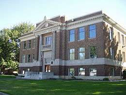
Benton County court house in Prosser. | |
 Location of Prosser, Washington | |
| Coordinates: 46°12′25″N 119°45′56″W / 46.20694°N 119.76556°WCoordinates: 46°12′25″N 119°45′56″W / 46.20694°N 119.76556°W | |
| Country | United States |
| State | Washington |
| County | Benton |
| Area[1] | |
| • Total | 4.53 sq mi (11.73 km2) |
| • Land | 4.49 sq mi (11.63 km2) |
| • Water | 0.04 sq mi (0.10 km2) |
| Elevation | 666 ft (203 m) |
| Population (2010)[2] | |
| • Total | 5,714 |
| • Estimate (2015)[3] | 5,869 |
| • Density | 1,272.6/sq mi (491.4/km2) |
| Time zone | Pacific (PST) (UTC-8) |
| • Summer (DST) | PDT (UTC-7) |
| ZIP code | 99350 |
| Area code | 509 |
| FIPS code | 53-56450 |
| GNIS feature ID | 1512582[4] |
| Website | cityofprosser.com |
Prosser is a city in and the county seat of Benton County, Washington, United States,[5] along the Yakima River with only one zip code 99350. The population was 5,714 at the 2010 census.
History
Prosser was long home to Native Americans who lived and fished along the river. They called the area "Tap tut", meaning rapids.
Colonel William Farrand Prosser first surveyed the area in 1879, then claimed homestead in 1882. The Northern Pacific Railroad laid tracks through the area two years later. A town plat was filed by Colonel Prosser in 1885, and in 1886 he was elected Yakima County Auditor. He moved to North Yakima to attend to these duties, and never returned to the town that he founded.
Lewis Hinzerling built a flour mill at Prosser falls in 1887, encouraging further settlement of the area. The first irrigation canal was completed in 1893 by the Prosser Falls Land and Irrigation Company. Prosser was officially incorporated in 1899 with a population of 229 people.
In 1905, Benton County was carved out of the eastern portions of Yakima and Klickitat Counties. The new town of Prosser was chosen as county seat. In 1907 a power plant was added and began delivering electricity to the town. The following year, a new high school was built, followed a year later by a telephone exchange. In 1910 the city received a grant from the Andrew Carnegie for a public library.
Throughout the 1910s and 1920s various companies drilled in this area for oil and natural gas. There were no large findings and the Great Depression put an end to exploration.
On November 5, 1912, Benton County voters held a referendum to move the county seat from Prosser to either Kennewick or Benton City. Intense rivalry and war of words between Benton City, Kennewick, and Prosser preceded the vote. Despite getting a majority of the vote, Kennewick did not receive 60 percent of the vote as required by law.[6] To date, Prosser remains the county seat.
In 1919, Washington State College (later WSU) established the Irrigation Experiment Station at Prosser. The program's mandate is to study the problems faced by farmers, orchardists, and ranchers in the dry central part of the state. The station originally employed scientists from the college in Pullman, who partnered with scientists from the Washington State Department of Agriculture (WSDA) and the United States Department of Agriculture (USDA). The station is still currently in use, and offers a number of agricultural education programs.
Prosser at one point had three newspapers, which were consolidated in the 1920s into the Prosser Record-Bulletin, and a permanent courthouse was built in 1926. The Benton County Historical Museum was dedicated in 1968.[7]
In more recent years, Prosser's location on a major river (the Yakima) and highway access has encouraged a growing wine business and associated tourist industry. Several Prosser wineries are located within the Yakima Valley appellation.
Annual events
- Prosser Community Awards Banquet In January the community honors hard working citizens and volunteers.
- Red Wine & Chocolate
- Sweet Retreat 2nd Saturday in March the Columbia Valley Winery Association hosts the pairing of sweet wine with food.
- Spring Barrel Tasting In April various wineries offer tasting.
- Wine Country Spring Fair In May on Mother's Day weekend arts and crafts in the park.
- Farmers Market Usually starts in May sometime and runs every weekend through harvest.
- The Dash Race for the Kids Early June after school lets out we have a bicycle competition a 62-mile "Metric Century" and youth fun run. Wine tasting after for the adults.
- Kestrel Festival Sponsored by Kestrel Wines. This takes place in June each year.
- Old Fashioned 4 July 4 July Weekend, includes a kiddie parade, car show, fireworks, bingo, stage shows, and food vendors in the park.
- Art Walk and Wine Gala Wine tasting event in the middle of July.
- A Night Out Beginning of September. Fundraising benefit of food and fun for the Prosser Memorial Foundation.
- Prosser State's Day Celebration Another one of the top events of the year. On Labor Day. There is a carnival in the city park, and a parade in the morning. Miss Prosser is crowned.
- The Great Prosser Balloon Rally The last of the top events. On September 23, 24, & 25th 2016, Hot air balloons are scheduled to launch just after dawn from the Prosser airport. Balloons glow from within at Art Fiker Stadium during The Great Prosser Balloon Rally Night Glow show.
- Annual Harvest Festival Same weekend as the Balloon Rally. Arts and crafts downtown with fun and food.
- Annual Caren Mercer-Andreason Street Painting Festival Same weekend as the Prosser Balloon Rally and Harvest Festival. Watch local and regional artists create works of art on the pavement in downtown Prosser.
- Thanksgiving in Wine Country Sunday after Thanksgiving. Sample all the newly released wines.
- Family Christmas Festival The annual lighting of the Christmas tree takes place with carolers and holiday music.
Geography
Prosser is located near the eastern end of the Yakima Valley at 46°12′25″N 119°45′56″W / 46.20694°N 119.76556°W (46.206921, -119.765612).[8] It is 665 ft above sea level. One river, the Yakima River, runs through it.
According to the United States Census Bureau, the city has a total area of 4.53 square miles (11.73 km2), of which, 4.49 square miles (11.63 km2) is land and 0.04 square miles (0.10 km2) is water.[1]
Climate
Prosser experiences a semi-arid climate (Köppen BSk).
| Climate data for Prosser (1971−2000) | |||||||||||||
|---|---|---|---|---|---|---|---|---|---|---|---|---|---|
| Month | Jan | Feb | Mar | Apr | May | Jun | Jul | Aug | Sep | Oct | Nov | Dec | Year |
| Average high °F (°C) | 41.0 (5) |
48.1 (8.9) |
58.1 (14.5) |
66.3 (19.1) |
74.5 (23.6) |
81.8 (27.7) |
89.3 (31.8) |
89.5 (31.9) |
80.4 (26.9) |
67.8 (19.9) |
51.3 (10.7) |
41.4 (5.2) |
65.79 (18.77) |
| Daily mean °F (°C) | 33.1 (0.6) |
38.6 (3.7) |
46.0 (7.8) |
52.6 (11.4) |
60.0 (15.6) |
66.5 (19.2) |
72.1 (22.3) |
71.9 (22.2) |
63.8 (17.7) |
53.1 (11.7) |
41.5 (5.3) |
33.7 (0.9) |
52.74 (11.53) |
| Average low °F (°C) | 25.1 (−3.8) |
29.0 (−1.7) |
33.8 (1) |
38.8 (3.8) |
45.4 (7.4) |
51.1 (10.6) |
54.9 (12.7) |
54.3 (12.4) |
47.2 (8.4) |
38.4 (3.6) |
31.7 (−0.2) |
25.9 (−3.4) |
39.63 (4.23) |
| Average precipitation inches (mm) | 0.96 (24.4) |
0.70 (17.8) |
0.67 (17) |
0.64 (16.3) |
0.65 (16.5) |
0.56 (14.2) |
0.24 (6.1) |
0.35 (8.9) |
0.48 (12.2) |
0.65 (16.5) |
1.03 (26.2) |
1.18 (30) |
8.11 (206.1) |
| Source: NOAA (normals, 1971−2000) [9] | |||||||||||||
Demographics
| Historical population | |||
|---|---|---|---|
| Census | Pop. | %± | |
| 1900 | 229 | — | |
| 1910 | 1,298 | 466.8% | |
| 1920 | 1,697 | 30.7% | |
| 1930 | 1,569 | −7.5% | |
| 1940 | 1,719 | 9.6% | |
| 1950 | 2,636 | 53.3% | |
| 1960 | 2,763 | 4.8% | |
| 1970 | 2,954 | 6.9% | |
| 1980 | 3,896 | 31.9% | |
| 1990 | 4,476 | 14.9% | |
| 2000 | 4,838 | 8.1% | |
| 2010 | 5,714 | 18.1% | |
| Est. 2015 | 5,869 | [10] | 2.7% |
| U.S. Decennial Census[11] 2015 Estimate[3] | |||
The median age is 32 years old. The median house value was $98,500 (2000). For population 15 years and over in Prosser city
- Never married: 18.1%
- Now married: 64.1%
- Separated: 1.9%
- Widowed: 7.5%
- Divorced: 10.9%
For population 20 years and over in Prosser:
- High school or higher: 68.0%
- Bachelor's degree or higher: 16.2%
- Graduate or professional degree: 6.0%
- Unemployed: 6.6%
- Mean travel time to work: 18.9 minutes
2010 census
As of the census[2] of 2010, there were 5,714 people, 2,023 households, and 1,396 families residing in the city. The population density was 1,272.6 inhabitants per square mile (491.4/km2). There were 2,129 housing units at an average density of 474.2 per square mile (183.1/km2). The racial makeup of the city was 76.1% White, 0.5% African American, 0.5% Native American, 2.0% Asian, 0.1% Pacific Islander, 17.6% from other races, and 3.2% from two or more races. Hispanic or Latino of any race were 37.2% of the population.
There were 2,023 households of which 39.8% had children under the age of 18 living with them, 49.3% were married couples living together, 14.2% had a female householder with no husband present, 5.4% had a male householder with no wife present, and 31.0% were non-families. 27.3% of all households were made up of individuals and 13.8% had someone living alone who was 65 years of age or older. The average household size was 2.80 and the average family size was 3.42.
The median age in the city was 32.8 years. 30.8% of residents were under the age of 18; 8.8% were between the ages of 18 and 24; 25.5% were from 25 to 44; 21.4% were from 45 to 64; and 13.5% were 65 years of age or older. The gender makeup of the city was 47.7% male and 52.3% female.
2000 census
As of the census of 2000, there were 4,838 people 1,697 households, and 1,240 families residing in the city. The population density was 1,125.1 people per square mile (434.4/km²). There were 1,800 housing units at an average density of 418.6 per square mile (161.6/km²). The racial makeup of the city was 79.89% White, 0.54% African American, 0.91% Native American, 0.76% Asian, 0.29% Pacific Islander, 15.11% from other races, and 2.50% from two or more races. Hispanic or Latino of any race were 29.37% of the population. Ancestries: German (17.3%), English (10.8%), Irish (9.3%), United States (6.8%), Norwegian (4.3%), French (4.2%), 12.5% Foreign born (99.1% Mexican).
There were 1,697 households out of which 41.5% had children under the age of 18 living with them, 57.2% were married couples living together, 12.2% had a female householder with no husband present, and 26.9% were non-families. 24.0% of all households were made up of individuals and 10.9% had someone living alone who was 65 years of age or older. The average household size was 2.83 and the average family size was 3.38.
In the city the age distribution of the population shows 32.5% under the age of 18, 9.6% from 18 to 24, 26.0% from 25 to 44, 19.5% from 45 to 64, and 12.3% who were 65 years of age or older. The median age was 32 years. For every 100 females there were 91.4 males. For every 100 females age 18 and over, there were 88.8 males.
The median income for a household in the city was $39,185, and the median income for a family was $45,162. Males had a median income of $36,750 versus $26,146 for females. The per capita income for the city was $16,302. About 11.5% of families and 13.5% of the population were below the poverty line, including 21.1% of those under age 18 and 2.6% of those age 65 or over.
Economy
The economy of Prosser is based on agriculture. In addition to fruit orchards and fruit packing plants, Prosser is an important center of wine making in the Yakima Valley American Viticultural Area.
Schools
- Prosser High School Grades 9-12, 843 Students
- Prosser Falls Education Center Grades 9-12, 69 Students
- Housel Middle School Grades 6-8, 676 Students
- Prosser Heights Elementary Grades 3-5, 676 Students
- Keene-Riverview Elementary Grades K-2, 480 students
- Whitstran Elementary Grades K-5, 285 Students
Wine
Prosser now has nearly 40 wineries in an area about ten-by-ten miles, as well as being home to the WSU extension office that proved the soils of Washington were suitable for growing wine grapes. Prosser is also home to 2 microbreweries and a distillery.
Crime
| Prosser | |
| Crime rates (2012) | |
| Crime type | Rate* |
|---|---|
| Homicide: | 0 |
| Robbery: | 2 |
| Aggravated assault: | 10 |
| Total violent crime: | 13 |
| Burglary: | 26 |
| Larceny-theft: | 108 |
| Motor vehicle theft: | 21 |
| Arson: | 1 |
| Total property crime: | 155 |
| Notes * Number of reported crimes per 100,000 population. 2012 population: 5,952 |
|
| Source: 2012 FBI UCR Data | |
In 2011, there were 0 murders, 5 rapes and 3 robberies in Prosser.
Major highways and closest cities
- Interstate 82
- U.S. Route 12
- State Route 221
- State Route 22
- Grandview, Washington 8 miles
- Mabton, Washington 12 miles
- Sunnyside, Washington 15 miles
- Benton City, Washington 17 miles
Notable people
- Mary L. Boas — An American mathematician and physics instructor and author
- George Boomer — Socialist newspaper editor and 1908 gubernatorial candidate
- Walter Clore — Father of Washington wine
- Harold McCluskey — "The Atomic Man"
- Kellen Moore — NFL Quarterback for the Dallas Cowboys. Former All American quarterback for Boise State University and local Prosser High School.
- Colonel William Farrand Prosser — city founder, U.S. Army Colonel in the Civil War
- The Rt. Rev. Brian Norman Prior - IX Bishop of the Episcopal Church in Minnesota
See also
References
- 1 2 "US Gazetteer files 2010". United States Census Bureau. Retrieved 2012-12-19.
- 1 2 "American FactFinder". United States Census Bureau. Retrieved 2012-12-19.
- 1 2 "Population Estimates". United States Census Bureau. Retrieved June 30, 2016.
- ↑ "US Board on Geographic Names". United States Geological Survey. 2007-10-25. Retrieved 2008-01-31.
- ↑ "Find a County". National Association of Counties. Retrieved 2011-06-07.
- ↑ http://historylink.org/index.cfm?DisplayPage=output.cfm&file_id=7744
- ↑ About the Prosser Record-Bulletin
- ↑ "US Gazetteer files: 2010, 2000, and 1990". United States Census Bureau. 2011-02-12. Retrieved 2011-04-23.
- ↑ "Climatography of the United States NO.81" (PDF). National Oceanic and Atmospheric Administration. Retrieved January 11, 2011.
- ↑ "Annual Estimates of the Resident Population for Incorporated Places: April 1, 2010 to July 1, 2015". Retrieved July 2, 2016.
- ↑ United States Census Bureau. "Census of Population and Housing". Retrieved September 19, 2013.
External links
- Prosser Chamber Of Commerce
- Yakima Valley Visitors & Convention Bureau
- Prosser, Washington at DMOZ
- Prosser Heritage. Digitized historical resources from the Prosser branch of Mid-Columbia Libraries and the Benton County Museum & Historical Society.
Municipalities and communities of Benton County, Washington, United States | ||
|---|---|---|
| Cities | 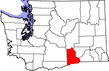 | |
| CDPs | ||
| Unincorporated communities | ||
| Unincorporated communities | ||