Putney, Vermont
| Putney, Vermont | |
|---|---|
| Town | |
|
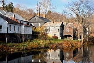
Sacketts Brook in downtown Putney (2009) | |
 Putney, Vermont | |
 Putney, Vermont Location in the United States | |
| Coordinates: 43°0′1″N 72°31′2″W / 43.00028°N 72.51722°WCoordinates: 43°0′1″N 72°31′2″W / 43.00028°N 72.51722°W | |
| Country | United States |
| State | Vermont |
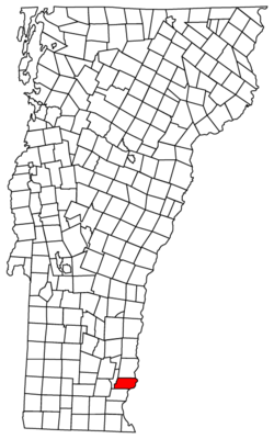
| County | Windham |
| Area | |
| • Total | 26.8 sq mi (69.4 km2) |
| • Land | 26.8 sq mi (69.4 km2) |
| • Water | 0.0 sq mi (0.0 km2) |
| Elevation | 404 ft (123 m) |
| Population (2010) | |
| • Total | 2,702 |
| • Density | 98.3/sq mi (37.9/km2) |
| Time zone | Eastern (EST) (UTC-5) |
| • Summer (DST) | EDT (UTC-4) |
| ZIP code | 05346 |
| Area code(s) | 802 |
| FIPS code | 50-57700[1] |
| GNIS feature ID | 1462181[2] |
Putney is a town in Windham County, Vermont, United States. The population was 2,702 at the 2010 census.
The town's historic core makes up the Putney Village Historic District, which is listed on the National Register of Historic Places.
History
On December 26, 1753 Col. Josiah Willard led a proprietors' petition for a Putney charter to be established in the Equivalent lands. The charter was to be issued by Governor Benning Wentworth (issuer of the New Hampshire Grants) under King George II of England that same day.[3]
Geography
According to the United States Census Bureau, the town has a total area of 26.8 square miles (69.4 km2), of which 26.76 square miles (69.4 km2) is land and 0.04% is water. Putney Mountain is the highest point in the town, rising 1,657ft above sea level.[4]
Putney is bordered by Dummerston to the south, Westminster to the north, and Brookline to the west. The Connecticut River serves as the eastern border of Putney, separating the town from Westmoreland, NH. Putney is approximately 10 miles north of Brattleboro, VT and 25 miles northwest of Keene, NH. US Route 5 and Interstate 91 both pass through Putney. Putney is accessible from Interstate 91 at Exit 4 near the border of Putney and Dummerston.
Demographics
| Historical population | |||
|---|---|---|---|
| Census | Pop. | %± | |
| 1790 | 1,848 | — | |
| 1800 | 1,574 | −14.8% | |
| 1810 | 1,607 | 2.1% | |
| 1820 | 1,547 | −3.7% | |
| 1830 | 1,510 | −2.4% | |
| 1840 | 1,382 | −8.5% | |
| 1850 | 1,425 | 3.1% | |
| 1860 | 1,163 | −18.4% | |
| 1870 | 1,167 | 0.3% | |
| 1880 | 1,124 | −3.7% | |
| 1890 | 1,075 | −4.4% | |
| 1900 | 969 | −9.9% | |
| 1910 | 788 | −18.7% | |
| 1920 | 761 | −3.4% | |
| 1930 | 835 | 9.7% | |
| 1940 | 904 | 8.3% | |
| 1950 | 1,019 | 12.7% | |
| 1960 | 1,177 | 15.5% | |
| 1970 | 1,727 | 46.7% | |
| 1980 | 1,850 | 7.1% | |
| 1990 | 2,352 | 27.1% | |
| 2000 | 2,634 | 12.0% | |
| 2010 | 2,702 | 2.6% | |
| Est. 2014 | 2,681 | [5] | −0.8% |
| U.S. Decennial Census[6] | |||
As of the census[1] of 2000, there were 2,634 people, 958 households, and 603 families residing in the town. The population density was 98.3 people per square mile (37.9/km2). There were 1,049 housing units at an average density of 39.1 per square mile (15.1/km2). The racial makeup of the town was 95.63% White, 1.03% African American, 0.49% Native American, 0.76% Asian, 0.04% Pacific Islander, 0.30% from other races, and 1.75% from two or more races. Hispanic or Latino of any race were 1.56% of the population.
There were 958 households out of which 32.5% had children under the age of 18 living with them, 50.5% were married couples living together, 8.5% had a female householder with no husband present, and 37.0% were non-families. 27.9% of all households were made up of individuals and 7.0% had someone living alone who was 65 years of age or older. The average household size was 2.43 and the average family size was 2.99.
In the town the population was spread out with 22.6% under the age of 18, 16.5% from 18 to 24, 27.5% from 25 to 44, 23.7% from 45 to 64, and 9.8% who were 65 years of age or older. The median age was 36 years. For every 100 females there were 106.3 males. For every 100 females age 18 and over, there were 108.0 males.
The median income for a household in the town was $40,346, and the median income for a family was $50,170. Males had a median income of $29,922 versus $25,217 for females. The per capita income for the town was $18,576. About 6.2% of families and 8.4% of the population were below the poverty line, including 8.5% of those under age 18 and 5.4% of those age 65 or over.
Education
- The Putney School is a private independent co-educational boarding and day high school.
- Landmark College was the first college exclusively for learning disabled students.
- The Greenwood School is a boarding school for boys ages 9–15 who have been diagnosed with dyslexia and/or related language-based learning disabilities.[7]
- Putney Central School is the town's public school for Pre-K through grade 8
Notable people
- George Aiken, US senator and 64th governor of Vermont
- Fernando Gerassi, painter
- William Haile, merchant, manufacturer and politician
- Carmelita Hinton, progressive educator and founder of The Putney School
- Reid Hoffman, entrepreneur, founder of LinkedIn, venture capitalist, graduate of The Putney School
- John Irving, Acclaimed author, Academy Award winner taught at Windham College while he wrote his first novel
- Errol Morris, Documentary Film Maker, MacArthur Fellowship recipient, Academy Award winner, graduate of the Putney School
- Manon Kahle, actress
- Melissa Leo, actress
- John Humphrey Noyes, American utopian socialist
- Peter Shumlin, 81st and current governor of Vermont
- Jody Williams, 1997 Nobel Peace Prize Laureate[8]
- John Henry Williams, only son of baseball legend Ted Williams
See also
 Vermont portal
References
- 1 2 "American FactFinder". United States Census Bureau. Retrieved 2008-01-31.
- ↑ "US Board on Geographic Names". United States Geological Survey. 2007-10-25. Retrieved 2008-01-31.
- ↑ Child, Hamilton (1884). Gazetteer and Business Directory of Windham County, Vt., 1724-1884. The Journal Office, Syracuse, N. Y.: Hamilton Child. pp. 272–286.
- ↑ "Putney Mountain". peakery.com. Retrieved 2016-01-11.
- ↑ "Annual Estimates of the Resident Population for Incorporated Places: April 1, 2010 to July 1, 2014". Retrieved June 4, 2015.
- ↑ "U.S. Decennial Census". United States Census Bureau. Retrieved May 16, 2015.
- ↑ Greenwood School website
- ↑ NobelPrize.org, The Nobel Prize in Peace 1997, International Campaign to Ban Landmines , Jody Williams
External links
-
 Media related to Putney, Vermont at Wikimedia Commons
 - Putney Vermont Official Town Website
- Putney Historical Society website
- Putney.net
- iPutney.com - local news and events
Municipalities and communities of Windham County, Vermont, United States | ||
|---|---|---|
| Towns | 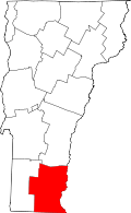 | |
| Villages | ||
| CDPs | ||
| Other communities | ||
| Footnotes | ‡ Disincorporated | |