Pyrgos, Elis
| Pyrgos Πύργος | ||
|---|---|---|
|
Pyrgos municipality | ||
| ||
 Pyrgos | ||
|
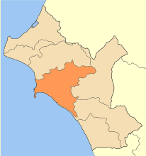
Location within the region 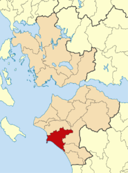 | ||
| Coordinates: 37°40′N 21°26′E / 37.667°N 21.433°ECoordinates: 37°40′N 21°26′E / 37.667°N 21.433°E | ||
| Country | Greece | |
| Administrative region | West Greece | |
| Regional unit | Elis | |
| Government | ||
| • Mayor | Gavrilis Liatsis | |
| Area | ||
| • Municipality | 456.6 km2 (176.3 sq mi) | |
| • Municipal unit | 170.9 km2 (66.0 sq mi) | |
| Highest elevation | 3 m (10 ft) | |
| Lowest elevation | 0 m (0 ft) | |
| Population (2011)[1] | ||
| • Municipality | 47,995 | |
| • Municipality density | 110/km2 (270/sq mi) | |
| • Municipal unit | 35,572 | |
| • Municipal unit density | 210/km2 (540/sq mi) | |
| Community[1] | ||
| • Population | 25,180 (2011) | |
| Time zone | EET (UTC+2) | |
| • Summer (DST) | EEST (UTC+3) | |
| Postal code | 271 xx | |
| Area code(s) | 26210 | |
| Vehicle registration | HA | |
| Website | ||

Pyrgos (Greek: Πύργος, meaning "tower") is the capital of the Elis regional unit in Greece. The city is located in the western part of the Peloponnese, in the middle of a plain, 4 kilometres (2 miles) from the Ionian Sea. The river Alfeios flows into sea about 7 km (4 mi) south of Pyrgos. The population of the town Pyrgos is 25,180, and of the municipality 47,995 (2011). Pyrgos is 16 km (10 mi) west of Olympia, 16 km (10 mi) southeast of Amaliada, 70 km (43 mi) southwest of Patras and 85 km (53 mi) west of Tripoli.
Historical population
| Year | Town population | Municipal unit population | Municipality population |
|---|---|---|---|
| 1981 | 21,958 | - | - |
| 1991 | 28,465 | 39,183 | - |
| 2001 | 23,791 | 34,902 | 51,777 |
| 2011 | 24,359 | 35,572 | 47,995 |
Municipality
The municipality Pyrgos was formed at the 2011 local government reform by the merger of the following 4 former municipalities, that became municipal units:[2]
The municipality has an area of 456.610 km2, the municipal unit 170.866 km2.[3]
Subdivisions
The municipal unit of Pyrgos is divided into the following communities (settlements within the communities given in brackets):
- Pyrgos (Pyrgos, Anthopyrgos, Kavasilakia, Lampeti, Syntriada, Tragano)
- Agios Georgios
- Agios Ilias (Agios Ilias, Pyrgi, Stamatelaiika)
- Agios Ioannis (Agios Ioannis, Kyani Akti, Palatas, Tragano)
- Ampelonas (Ampelonas, Kouzouli, Rozeika)
- Elaionas (Elaionas, Vytinaiika)
- Granitsaiika (Granitsaiika, Kavouri)
- Katakolo (Katakolo, Agios Andreas)
- Koliri (Koliri, Kolireikes Paragkes)
- Korakochori (Korakochori, Agios Andreas, Kallithea, Bouka)
- Lasteika (Lasteika, Itia)
- Leventochori
- Myrtia
- Palaiovarvasaina (Palaiovarvasaina, Agios Georgios, Kampos)
- Salmoni (Salmoni, Alfeios)
- Skafidia (Skafidia, Kalakaiika, Moni Skafidias, Patronikoleika)
- Skourochori (Skourochori, Kato Kavouri)
- Varvasaina (Varvasaina, Kato Varvasaina)
- Vytinaiika
Climate
| Climate data for Pyrgos | |||||||||||||
|---|---|---|---|---|---|---|---|---|---|---|---|---|---|
| Month | Jan | Feb | Mar | Apr | May | Jun | Jul | Aug | Sep | Oct | Nov | Dec | Year |
| Average high °C (°F) | 14.6 (58.3) |
15.0 (59) |
17.2 (63) |
19.8 (67.6) |
24.6 (76.3) |
28.9 (84) |
31.7 (89.1) |
31.8 (89.2) |
29.1 (84.4) |
24.7 (76.5) |
19.3 (66.7) |
15.9 (60.6) |
22.72 (72.89) |
| Daily mean °C (°F) | 9.6 (49.3) |
10.1 (50.2) |
12.2 (54) |
15.0 (59) |
19.6 (67.3) |
23.8 (74.8) |
26.3 (79.3) |
26.1 (79) |
23.0 (73.4) |
18.5 (65.3) |
13.9 (57) |
11.0 (51.8) |
17.43 (63.37) |
| Average low °C (°F) | 4.8 (40.6) |
5.1 (41.2) |
6.3 (43.3) |
8.6 (47.5) |
12.0 (53.6) |
14.9 (58.8) |
17.0 (62.6) |
17.4 (63.3) |
15.1 (59.2) |
12.3 (54.1) |
9.1 (48.4) |
6.5 (43.7) |
10.76 (51.36) |
| Average rainfall mm (inches) | 136.4 (5.37) |
111.5 (4.39) |
71.5 (2.815) |
63.3 (2.492) |
24.0 (0.945) |
8.2 (0.323) |
4.5 (0.177) |
14.7 (0.579) |
27.7 (1.091) |
103.4 (4.071) |
194.0 (7.638) |
161.7 (6.366) |
920.9 (36.257) |
| Average rainy days | 12.2 | 11.5 | 9.6 | 8.5 | 5.6 | 1.9 | 0.7 | 1.3 | 3.2 | 8.0 | 12.2 | 13.2 | 87.9 |
| Average relative humidity (%) | 73.5 | 71.8 | 71.1 | 70.5 | 67.7 | 62.4 | 60.1 | 62.5 | 67.0 | 70.8 | 75.2 | 75.5 | 69.01 |
| Mean monthly sunshine hours | 143.2 | 147.4 | 193.4 | 227.2 | 285.3 | 332.3 | 360.4 | 333.9 | 263.6 | 215.2 | 152.5 | 124.9 | 2,779.3 |
| Source: Hellenic National Meteorological Service [4] | |||||||||||||
Transportation
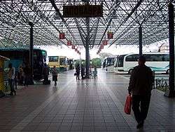
Pyrgos has a train station with regular trains to the port of Katakolo and Olympia. Service on the line from Patras to Kalamata via Pyrgos has been suspended in 2011. Pyrgos has a bus terminal, served by KTEL Ileias, with regular buses for the regional routes to most places in Elis as well as for intercity routes to larger cities such as Patras, Kalamata, Ioannina, Athens and Thessaloniki.[5] The Greek National Road 9 connects Pyrgos with Patras and Kyparissia, the Greek National Road 74 run from Pyrgos to Tripoli via Olympia.
Sporting teams
- Paniliakos (played in the first division during the 2003–2004 season)
Notable people
- Andreas Avgerinos (1820–1895), politician
- Petros Avgerinos (19th century), politician, mayor of Pyrgos
- Nakis Avgerinos (1911–2001), politician
- Giorgos Karagounis (1977-), footballer
- Kostas Kazakos (1935-), actor and politician
- George Pavlopoulos (1924-2008), poet
- Takis Sinopoulos (1917–1981), poet
- Stephanos Stephanopoulos (1898–1982), politician and 165th Prime Minister of Greece
- Theodoros Xydis, (1909-1985), poet and essayist.
See also
References
- 1 2 "Απογραφή Πληθυσμού - Κατοικιών 2011. ΜΟΝΙΜΟΣ Πληθυσμός" (in Greek). Hellenic Statistical Authority.
- ↑ Kallikratis law Greece Ministry of Interior (Greek)
- ↑ "Population & housing census 2001 (incl. area and average elevation)" (PDF) (in Greek). National Statistical Service of Greece.
- ↑ "Mean Pyrgos Climatic Averages". Hellenic National Meteorological Service. Retrieved 14 June 2015.
- ↑ KTEL Ileias
External links
 |
Amaliada | Iardanos, Amaliada | Oleni | |
| Ionian Sea | |
Archaia Olympia | ||
| ||||
| | ||||
| Ionian Sea | Volakas |
| Regional unit of Achaea |  | |
|---|---|---|
| Regional unit of Aetolia-Acarnania | ||
| Regional unit of Elis | ||
| ||