Quesnel, British Columbia
| Quesnel | |
|---|---|
| City | |
| City of Quesnel | |
|
The Quesnel gold pan | |
| Motto: In Situ | |
 Quesnel Location of Quesnel in British Columbia | |
| Coordinates: 52°58′42.4″N 122°29′33.6″W / 52.978444°N 122.492667°WCoordinates: 52°58′42.4″N 122°29′33.6″W / 52.978444°N 122.492667°W | |
| Country | Canada |
| Province | British Columbia |
| Region | North Cariboo |
| Regional district | Cariboo Regional District |
| Founded | 1861 |
| Incorporated as Village | 1928 |
| Incorporated as Town | 1958 |
| Incorporated as City | 1981 |
| Government | |
| • Mayor | Bob Simpson |
| • Governing body | Quesnel City Council |
| Area | |
| • City | 35.38 km2 (13.66 sq mi) |
| • Metro | 14,207.04 km2 (5,485.37 sq mi) |
| Elevation | 474 m (1,555 ft) |
| Population (2011) | |
| • City | 10,007 |
| • Density | 282.8/km2 (732/sq mi) |
| • Metro | 22,096 |
| • Metro density | 1.6/km2 (4/sq mi) |
| Time zone | PST (UTC−8) |
| Postal code span | V2J |
| Area code(s) | 250, 778, 236 |
| Highways |
|
| Waterways |
Bowron Lake Fraser River, Quesnel River |
| Website | http://www.quesnel.ca/ |
|
| |
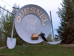
Quesnel /kwəˈnɛl/ is a small city that is part of the Cariboo District of British Columbia, Canada. Located nearly evenly between the cities of Prince George and Williams Lake, it is on the main route to northern British Columbia and Yukon. It is claimed to be home to the world's largest gold pan, although this is disputed by Nome, Alaska. The Rocky Mountaineer train also travels through and stops overnight in Quesnel.
Quesnel is sister city to Shiraoi, Japan and Val-d'Or, Quebec. Quesnel hosted the 2000 British Columbia Winter Games, an annual provincial amateur sports competition. To the east of Quesnel lie Wells, Barkerville, and Bowron Lake Provincial Park, a popular canoeing destination in the Cariboo Mountains.
History
The name is derived from Jules Maurice Quesnel, who accompanied Simon Fraser on his journey to the Pacific Ocean. Quesnel came to be called 'Quesnellemouth' to distinguish it from 'Quesnel Forks', 97 kilometres (60 mi) up river. In 1870 it had been shortened to Quesnelle and by 1900 it was spelled the way it is now. Quesnel is located along the gold mining trail known as the Cariboo Wagon Road and was the commercial centre of the Cariboo Gold Rush. It also marks one end of the Alexander MacKenzie Heritage Trail. Because of its location on the Fraser River it was also an important landing for sternwheelers during 1862 until 1886 and then from 1909 until 1921. The last sternwheeler on the upper Fraser was Quesnel's own namesake craft, and home town product, the Quesnel. Quesnel was incorporated in 1928.
Geography and climate
- Location: 52°59′N 122°29′W / 52.983°N 122.483°W
- Elevation: 474 m (1,555.1 ft)
- Average Annual Snowfall: 177.9 cm (70.0 in)
- Average Annual Rainfall: 540.3 mm (21.3 in)
- Frost Free Days: 179
- Average Winter Temperature: −8.6 °C (16.5 °F)
- Extreme Minimum Temperature: −46.7 °C (−52.1 °F)
- Average Summer Temperature: 16.7 °C (62.1 °F)
- Extreme Maximum Temperature: 36.7 °C (98.1 °F)
- Time Zone: Pacific Standard Time
Climate
Considering it being located inland and around the 53rd parallel north Quesnel's humid continental climate[1] is very mild by Canadian standards, being subject to marine airflows from the Pacific. Overnight lows are still cool even in summer, but daytime temperatures average above 24 °C (75 °F) in that season according to Environment Canada.
| Climate data for Quesnel Airport | |||||||||||||
|---|---|---|---|---|---|---|---|---|---|---|---|---|---|
| Month | Jan | Feb | Mar | Apr | May | Jun | Jul | Aug | Sep | Oct | Nov | Dec | Year |
| Record high humidex | 13.8 | 15 | 21.8 | 30.8 | 36.6 | 36 | 41.9 | 36.8 | 37 | 27.1 | 16.6 | 11.7 | 41.9 |
| Record high °C (°F) | 13.9 (57) |
15.1 (59.2) |
22.3 (72.1) |
31 (88) |
36.5 (97.7) |
35.6 (96.1) |
36.7 (98.1) |
36.2 (97.2) |
36.1 (97) |
26.8 (80.2) |
17.2 (63) |
12.2 (54) |
36.7 (98.1) |
| Average high °C (°F) | −2.9 (26.8) |
1.3 (34.3) |
7.3 (45.1) |
13.5 (56.3) |
18.4 (65.1) |
21.7 (71.1) |
24.1 (75.4) |
24.1 (75.4) |
18.5 (65.3) |
10.8 (51.4) |
2.1 (35.8) |
−2.3 (27.9) |
11.4 (52.5) |
| Daily mean °C (°F) | −6.9 (19.6) |
−3.6 (25.5) |
1.3 (34.3) |
6.4 (43.5) |
11.1 (52) |
14.7 (58.5) |
16.8 (62.2) |
16.4 (61.5) |
11.5 (52.7) |
5.5 (41.9) |
−1.4 (29.5) |
−5.9 (21.4) |
5.5 (41.9) |
| Average low °C (°F) | −10.8 (12.6) |
−8.3 (17.1) |
−4.7 (23.5) |
−0.8 (30.6) |
3.7 (38.7) |
7.6 (45.7) |
9.5 (49.1) |
8.6 (47.5) |
4.5 (40.1) |
0.2 (32.4) |
−5 (23) |
−9.6 (14.7) |
−0.4 (31.3) |
| Record low °C (°F) | −46.7 (−52.1) |
−42.2 (−44) |
−38.9 (−38) |
−20 (−4) |
−10 (14) |
−3.3 (26.1) |
0.6 (33.1) |
−2.6 (27.3) |
−8.9 (16) |
−28.4 (−19.1) |
−37.8 (−36) |
−41.1 (−42) |
−46.7 (−52.1) |
| Record low wind chill | −48 | −43.1 | −41.7 | −25.1 | −10.1 | −1.7 | 0 | −1 | −8.7 | −27.2 | −47.5 | −47.4 | −48 |
| Average precipitation mm (inches) | 47.8 (1.882) |
22.7 (0.894) |
24.9 (0.98) |
24.5 (0.965) |
42.6 (1.677) |
66.4 (2.614) |
65.6 (2.583) |
46.2 (1.819) |
50.2 (1.976) |
52.6 (2.071) |
51.3 (2.02) |
41.6 (1.638) |
536.2 (21.11) |
| Average rainfall mm (inches) | 10.4 (0.409) |
6.7 (0.264) |
12.7 (0.5) |
21.2 (0.835) |
41.4 (1.63) |
66.4 (2.614) |
65.6 (2.583) |
46.2 (1.819) |
50.2 (1.976) |
46.3 (1.823) |
22.3 (0.878) |
4.9 (0.193) |
394.3 (15.524) |
| Average snowfall cm (inches) | 44 (17.3) |
19 (7.5) |
13.4 (5.28) |
3.6 (1.42) |
1.2 (0.47) |
0 (0) |
0 (0) |
0 (0) |
0 (0) |
6.7 (2.64) |
31.5 (12.4) |
42.8 (16.85) |
162.1 (63.82) |
| Average precipitation days (≥ 0.2 mm) | 12.8 | 9.7 | 9.7 | 9.8 | 12.1 | 15.8 | 14.2 | 12 | 12.4 | 14.8 | 14 | 13.4 | 150.7 |
| Average rainy days (≥ 0.2 mm) | 3.1 | 3.4 | 5.9 | 8.8 | 11.9 | 15.8 | 14.2 | 12 | 12.4 | 13.7 | 7.2 | 2.4 | 110.8 |
| Average snowy days (≥ 0.2 cm) | 11.3 | 7.1 | 5.4 | 2.2 | 0.7 | 0 | 0 | 0 | 0 | 2.4 | 8.8 | 11.8 | 49.7 |
| Average relative humidity (%) | 74.3 | 62 | 46.9 | 37.9 | 40 | 44.8 | 44.4 | 42.9 | 49.4 | 59 | 72.6 | 75.7 | 54.2 |
| Source: [2] | |||||||||||||
Demographics
Quesnel had a population of 9,326 people in 2006, which was a decrease of 7.1% from the 2001 census count. The median household income in 2005 for Quesnel was $54,044, which is slightly above the British Columbia provincial average of $52,709.[2]
As of 2012, the population of Quesnel is estimated to still be about 10,000 people living within the city, with roughly 13,000 people living outside the city limits.
| Canada 2011 Census | Population | % of Total Population | |
|---|---|---|---|
| Visible minority group Source:[3] |
South Asian | 485 | 4.9% |
| Chinese | 140 | 1.4% | |
| Black | 25 | 0.3% | |
| Filipino | 35 | 0.4% | |
| Latin American | 25 | 0.3% | |
| Arab | 1 | 0% | |
| Southeast Asian | 10 | 0.1% | |
| West Asian | 0 | 0% | |
| Korean | 0 | 0% | |
| Japanese | 0 | 0% | |
| Other visible minority | 0 | 0% | |
| Mixed visible minority | 0 | 0% | |
| Total visible minority population | 745 | 7.6% | |
| Aboriginal group Source:[4] | First Nations | 675 | 6.9% |
| Métis | 710 | 7.2% | |
| Inuit | 0 | 0% | |
| Total Aboriginal population | 1,415 | 14.4% | |
| White | 7,670 | 78% | |
| Total population | 9,830 | 100% | |
Administration
Quesnel's municipal government consists of a 7-member Mayor and Council. The current Council consists of Mayor Bob Simpson and Councillors Ed Coleman, Scott Elliott, Ron Paull, Laurey-Anne Roodenburg, Shushil Thapar and John Brisco.[5]
Education
Quesnel is part of School District 28. It contains several elementary schools, as well as a Junior and a Senior Secondary School (Quesnel Junior High School and Correlieu Senior Secondary school respectively). Also within the school district is McNaughton Centre which is an Alternate High school. For post secondary education, Quesnel contains the College of New Caledonia and University of Northern British Columbia, which offer several programs but is most noted for its Nursing program.
Transportation
Quesnel is served by the Quesnel Airport, with several commercial flights daily to & from Vancouver, BC. The city is a regular stop on Greyhound Canada's schedules between Kamloops and Prince George and also has a local transit system provided by BC Transit.
Sports
Quesnel was formerly home to the BCHL's Quesnel Millionaires junior A hockey team. The team moved to Chilliwack for the 2011/2012 season.[6]
Quesnel also has minor baseball, softball, lacrosse, ringette, roller derby, and football leagues. A Mountain biking skills park is located behind the Rec Center.
Notable residents
- Rory MacDonald - Mixed martial artist currently with Bellator MMA in the Welterweight division.
- Bob Gassoff - former National Hockey League player (St. Louis Blues).
- Brad Gassoff - former National Hockey League player (Vancouver Canucks).
- Rod Dallman - former National Hockey League player (New York Islanders & Philadelphia Flyers).
- Errol Rausse - former National Hockey League player (Washington Capitals).
- Aaron Gagnon - former National Hockey League Player (Dallas Stars & Winnipeg Jets).
- Brett Festerling - former National Hockey League Player (Anaheim Ducks & Winnipeg Jets).
Neighbourhoods and nearby communities
- Quesnel View
- West Quesnel
- Red Bluff
- Kersley
- Rich Bar
- Dragon Lake
- Cottonwood
- Nazko
- Bouchie Lake
Sister cities
Quesnel has "sister city" agreements with the following cities:
References
- ↑ "Quesnel, British Columbia Climate Summary". Weatherbase. Retrieved 22 October 2015.
- ↑ "Calculation Information for 1981 to 2010 Canadian Normals Data". Environment Canada. Retrieved July 9, 2013.
- ↑ "Community Profiles from the 2011 Census, Statistics Canada - Census Subdivision". 2.statcan.gc.ca. 2010-12-06. Retrieved 2013-04-13.
- ↑ "Aboriginal Peoples - Data table". 2.statcan.ca. 2010-10-06. Retrieved 2013-04-13.
- ↑ "Quesnel City Council". City of Quesnel. Retrieved 10 June 2013.
- ↑ "Quesnel Millionaires move to Chilliwack". Retrieved 2011-05-25.
External links
| Wikimedia Commons has media related to Quesnel. |
| Subdivisions | 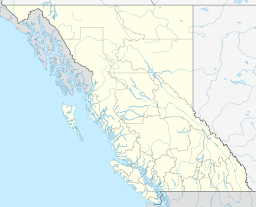 | |
|---|---|---|
| Communities | ||
| Metro areas and agglomerations | ||
| Cities |
| |
| ||