Quilcene, Washington
| Quilcene, Washington | |
|---|---|
| CDP | |
| Nickname(s): Pearl of the Peninsula | |
 Location of Quilcene, Washington | |
| Coordinates: 47°49′55″N 122°53′7″W / 47.83194°N 122.88528°WCoordinates: 47°49′55″N 122°53′7″W / 47.83194°N 122.88528°W | |
| Country | United States |
| State | Washington |
| County | Jefferson |
| Area | |
| • Total | 10.1 sq mi (26.2 km2) |
| • Land | 9.8 sq mi (25.3 km2) |
| • Water | 0.4 sq mi (1.0 km2) |
| Elevation | 43 ft (13 m) |
| Population (2000) | |
| • Total | 591 |
| • Density | 60.6/sq mi (23.4/km2) |
| Time zone | Pacific (PST) (UTC-8) |
| • Summer (DST) | PDT (UTC-7) |
| ZIP code | 98376 |
| Area code(s) | 360 |
| FIPS code | 53-56975[1] |
| GNIS feature ID | 1524768[2] |
Quilcene is a census-designated place (CDP) in Jefferson County, Washington, United States. The population was 591 at the 2000 census.
The community is located on the scenic Olympic Peninsula along the seawater-filled glacial valley of the Hood Canal.[3] Each year many visitors enjoy the panoramic views of Mount Rainier, Puget Sound and Seattle from the summit of nearby Mount Walker, the only peak facing the Puget Sound that has a road to its summit.[3] The Olympic National Forest lands in Quilcene hold a wealth of Douglas fir, spring-blooming Pacific rhododendrons, Oregon grape, and salal.[4] Leland Lake is located near Quilcene.
Quilcene oysters, named after the community, have an international reputation among restaurateurs.[5] Quilcene has one of the largest oyster hatcheries in the world. The canal's mild currents make it an ideal habitat for the oysters.
History
Early inhabitants of the area were the Twana, inhabiting the length of the Hood Canal, and rarely invading other tribes.[6] The Quilcene ("salt-water people") were a distinct band of these people.[7]
The Wilkes Expedition charted the place as Kwil-sid in 1841. Hampden Cottle, a logger from Maine, and several other families settled there in 1860 and eventually established a town.[8] The town was originally situated on the banks of the Quilcene river, before being moved to higher ground.[9] The economy in Quilcene was based primarily on farming and logging and by 1880, the town had a population of 53.[8]
The Tubal Cain Mining Company, in 1902, claimed that Quilcene would become the center for the smelting of iron, copper, gold, and manganese that was expected to be found in the Olympic Mountains; however, little ore was ever discovered.[8]
Circa 1910, Green's Shingle Mill was a large part of Quilcene's history.[10]
Culture
The Olympic Music Festival, based in Quilcene for 32 years until 2016, is a casual classical music event featuring world-renowned musicians that was held at a turn-of-the-century dairy farm nestled on 55 acres (220,000 m2) of tranquil farmland. The Olympic Music Festival was voted "Best Classical Music Festival" by readers of The Seattle Weekly. The music festival was founded in 1984 by Mr. Alan Iglitzin, originally intending the Festival to be a summer home for the Philadelphia String Quartet.[11] The Festival moved to nearby Fort Worden in 2016.
Geography
Quilcene is located at 47°49′55″N 122°53′7″W / 47.83194°N 122.88528°W (47.831838, -122.885339).[12]
According to the United States Census Bureau, the CDP has a total area of 10.1 square miles (26.2 km²), of which, 9.8 square miles (25.3 km²) of it is land and 0.4 square miles (1.0 km²) of it (3.75%) is water.
The Big Quilcene River and Little Quilcene River both flow through the town and into the Quilcene Bay.
The nearby Olympic National Forest lands contain Douglas fir, Pacific rhododendrons blooming in May and June,[3] salal, and Oregon grape. The summit of Mount Walker, at 2804 feet Mt. Walker View Point, offers vista views of Mount Jupiter, Buckhorn Mountain, Mount Constance, Mount Baker and the town of Quilcene.[4]
Covering 155,000 acres (630 km2) in the northeast corner of the Olympic Peninsula is the Hood Canal Ranger District. The area lies in the Olympic Mountains rainshadow and contains some of the driest ecosystems on the Olympic Forest. The district includes alpine botanical wonderlands, several major rivers, and the 50,000 acres (200 km2) of the Buckhorn Wilderness. Recreation opportunities include hiking and interpretive trails, oyster beach, campgrounds, and a self-guided auto tour.[13] The Quilcene Ranger Station also serves as the North Hood Canal Visitors Center.[14]
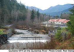
Two miles south of Quilcene and at the union of the Big Quilcene River and Penny Creek, covering slightly over 47 acres (190,000 m2), the Quilcene National Fish Hatchery has been operating since 1911. There, the US Fish and Wildlife Service raises coho salmon for on-station release as well as provides coho salmon eggs and fingerlings for tribal programs.[15]
Climate
Quilcene experiences an oceanic climate (Köppen climate classification Cfb) and is almost categorised as part of the Csb climate category, receiving slightly more than 30 millimetres (1.2 in), the threshold for Cfb inclusion.
| Climate data for Quilcene | |||||||||||||
|---|---|---|---|---|---|---|---|---|---|---|---|---|---|
| Month | Jan | Feb | Mar | Apr | May | Jun | Jul | Aug | Sep | Oct | Nov | Dec | Year |
| Record high °F (°C) | 64 (18) |
71 (22) |
78 (26) |
84 (29) |
91 (33) |
96 (36) |
100 (38) |
98 (37) |
99 (37) |
83 (28) |
74 (23) |
65 (18) |
100 (38) |
| Average high °F (°C) | 45 (7) |
50 (10) |
56 (13) |
61 (16) |
67 (19) |
72 (22) |
77 (25) |
79 (26) |
73 (23) |
62 (17) |
51 (11) |
44 (7) |
61.4 (16.3) |
| Average low °F (°C) | 31 (−1) |
33 (1) |
35 (2) |
38 (3) |
43 (6) |
48 (9) |
51 (11) |
50 (10) |
46 (8) |
40 (4) |
35 (2) |
31 (−1) |
40.1 (4.5) |
| Record low °F (°C) | 3 (−16) |
5 (−15) |
12 (−11) |
27 (−3) |
27 (−3) |
34 (1) |
35 (2) |
38 (3) |
29 (−2) |
22 (−6) |
5 (−15) |
4 (−16) |
3 (−16) |
| Average precipitation inches (mm) | 7.39 (187.7) |
7.38 (187.5) |
5.93 (150.6) |
3.81 (96.8) |
2.82 (71.6) |
2.13 (54.1) |
1.29 (32.8) |
1.24 (31.5) |
1.60 (40.6) |
4.13 (104.9) |
7.99 (202.9) |
8.65 (219.7) |
54.36 (1,380.7) |
| Source: [16] | |||||||||||||
Demographics
As of the 2010 census, 596 people lived in 312 households in the CDP,[17] representing a population increase of 6 and a household increase of 69 over the 2000 census). With 123 children under the age of 18, 20.6% are school age or younger.
In 2000, the population density was 60.6 people per square mile (23.4/km²). There were 284 housing units at an average density of 29.1/sq mi (11.2/km²). The racial makeup of the CDP was 84.77% White, 1.18% African American, 3.55% Native American, 0.34% Asian, 0.17% Pacific Islander, 0.85% from other races, and 9.14% from two or more races. Hispanic or Latino of any race were 1.35% of the population.
In 2000, there were 243 households out of which 27.6% had children under the age of 18 living with them, 51.9% were married couples living together, 7.8% had a female householder with no husband present, and 35.8% were non-families. 28.8% of all households were made up of individuals and 8.2% had someone living alone who was 65 years of age or older. The average household size was 2.42 and the average family size was 2.95.
In 2000, the median income for a household in the CDP was $40,385, and the median income for a family was $45,313. Males had a median income of $36,500 versus $24,063 for females. The per capita income for the CDP was $17,335. About 11.3% of families and 15.2% of the population were below the poverty line, including 20.0% of those under age 18 and none of those age 65 or over.
See also
References
- ↑ "American FactFinder". United States Census Bureau. Archived from the original on September 11, 2013. Retrieved 2008-01-31.
- ↑ "Quilcene". Geographic Names Information System. United States Geological Survey.
- 1 2 3 "Washington Byways Guide Book", Tony Huegel, Wilderness Press, 2003, ISBN 0-89997-299-3.
- 1 2 Mt. Walker Trail #894, Olympic National Forest.
- ↑ "Scenic Driving Washington", Steve Giordano, Globe Pequot, Falcon Guides Scenic Driving, 1997, ISBN 1-56044-577-7. p. 80
- ↑ Twana Edward Sheriff Curtis. The North American Indian. Volume 9, 1907-1930, p.30-31
- ↑ "Hiking Adventures with Children: Southern Vancouver Island and the Olympic Peninsula", Kari Jones and Sachiko Kiyooka, Heritage House, 2005
- 1 2 3 "Jefferson County, Thumbnail History, HistoryLink.org Essay 7472, Daryl C. McClary, September 26, 2005", T 2007.
- ↑ "Our Native American legacy: Northwest towns with Indian names", Sandy Nestor, Caxton Press, 2001, ISBN 0-87004-401-X
- ↑ "Winona Prill writes Quilcene heritage history book", The Port Townsend & Jefferson County Leader, Mari McGrady, May 2007.
- ↑ Olympic Music Festival Official Website
- ↑ "US Gazetteer files: 2010, 2000, and 1990". United States Census Bureau. 2011-02-12. Retrieved 2011-04-23.
- ↑ Official Olympic National Forest site, U.S.D.A.
- ↑ Olympic National Forest Recreation Report HOOD CANAL RANGER DISTRICT, Olympic National Forest.
- ↑ Quilcene National Fish Hatchery, US Fish and Wildlife Service
- ↑ "weather.com - Aches & Pains - Monthly Climatology". Weather.com. August 2011. Retrieved 23 January 2011.
- ↑ http://www.census.gov/popfinder/?fl=53:5356975
External links
- Quilcene and Brinnon Chamber of Commerce
- Quilcene School District
- Quilcene Historical Museum
- Quilcene National Fish Hatchery, US Fish and Wildlife Service
- Olympic National Park
- Olympic National Forest
- Jefferson County Library
Municipalities and communities of Jefferson County, Washington, United States | ||
|---|---|---|
| City | 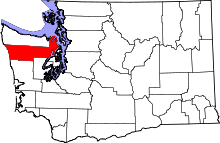 | |
| CDPs | ||
| Other unincorporated communities | ||
| Indian reservation | ||
| Ghost town | ||
| Footnotes | ‡This populated place also has portions in an adjacent county or counties | |