Transport in Western Sahara
Transport in Western Sahara is very limited by sea, road and air with camels being the primary means of transport in the desert area.[1] Road transport by buses remain the major mode of transportation. The longest conveyor belt in the world is 100 kilometres (62 mi) long, from the phosphate mines of Bu Craa to the coast south of Laayoune. The belt moves about 2,000 metric tons of rock containing phosphate every hour from the mines to El-Aaiun, where it is loaded and shipped.
The portions of Western Sahara was a Spanish Colony till 1975 as the last colonial province in Africa. A war erupted between those countries and the Sahrawi national liberation movement, the Polisario Front, which proclaimed the Sahrawi Arab Democratic Republic (SADR) with a government in exile in Tindouf, Algeria. Mauritania withdrew in 1979, and Morocco eventually secured control of most of the territory, including all the major cities and natural resources. With UN efforts ceasefire is implemented from 1997 between Polisario and Moroccan forces.
The world's longest cargo train, the Mauritania Railway cargo train, passes through Western Sahara for a small distance on the North eastern corner of Western Sahara to end at Nouadhibou. The transport through Western Sahara was seriously during the wars till 1997 between Polisaro and Moroccan forces, when ceasefire was established with UN effort.
Background
The portions of Western Sahara was a Spanish Colony till 1975 as the last colonial province in Africa.[2] A war erupted between those countries and the Sahrawi national liberation movement, the Polisario Front, which proclaimed the Sahrawi Arab Democratic Republic (SADR) with a government in exile in Tindouf, Algeria. Mauritania withdrew in 1979, and Morocco eventually secured control of most of the territory, including all the major cities and natural resources.[3] Polisario was formed in 1973 to fight for the rights of Sahawari Arab African People. Polisario attacked Moroccan positions many times and have retaliated. Continued war was waged between Polisario and Morocco over prominence in the region backed by Algeria for Polisario and US, France and Saudi Arabia for Morocco. [4] Polisario were successful in cutting the transport of Phosphorus across Western Sahara to Atlantic Coast. The transport infrastructure of the region, including the border towns of Morocco was affected during the wars.[5]
Surface transport
Western Sahara has no rail service,[6] with the exception of a 5-kilometre (3.1 mi) section of the Mauritania Railway; which (since the closure of the Choum Tunnel), cuts across the extreme south-eastern corner of the territory. The rail-route is considered the world's longest cargo train covering a distance of 437 mi (703 km).[7] Passengers with tickets ride in cramped cars while many illegal passengers, sometimes with livestock, ride on top of freight cars.[8]
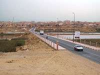
There are only 6,200 kilometres (3,900 mi) of roads, of which 1,126 kilometres (700 mi) are metalled.[9] A small network of highways provide limited ground travel connections. N1 highway is a major roadway traversing along the Atlantic coastline of the country. There are a few roads in the north and only two roads in the south that branches off of N1. All other roads are local ones in the various cities and towns. Off road driving is considered dangerous since there are "thousands of unexploded mines" in the area.[6] Highway road plans in the region started by Algeria have been used to increase its own influence in the region.[10] There are only 4 companies licensed to use buses in Western Sahara which are: CTM, Supratours, Satas and Sat CTM and Supratours buses have daily service from Dakhla to Marrakech via Laayoune and Agadir.[11]
Ports
The major port in Western Sahara are Ad Dakhla - small docking facility (Port Marchand Lassarga/Port-Îlot) located in a shelter bay south of the airport, Cabo Bojador - small port with fishing boats store inland and Laayoune (El Aaiun) - major deep water port facility; used by vessels carrying phosphate, large fishing vessels and military patrol boats. The longest conveyor belt in the world is 100 kilometres (62 mi) long, from the phosphate mines of Bu Craa to the coast south of Laayoune.[12] The belt moves about 2,000 metric tons of rock containing phosphate every hour from the mines to El-Aaiun, where it is loaded and shipped.[12]
Air transport
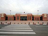
There are six airfields, three with paved runways and three unpaved surfaces, and one helipad (military in Cape Bojador). Hassan I Airport, serving El Aaiún (Laâyoune), is an international airport, but the carriers at the airport connect only to regional destinations (to Morocco or the Canary Islands). Dakhla Airport is located on Dakhla and has commercial operational flights. Smara Airport in Smara and La Güera Airport serving La Güera are other smaller airports in Western Sahara.[13]
See also
Sources
- CIA World Factbook (2010).
References
- ↑ Pablo San Martin (1 October 2010), Western Sahara: The Refugee Nation, University of Wales Press, p. 28, ISBN 978-0-70-832381-6
- ↑ González Campo, Julio. "Documento de Trabajo núm. 15 DT-2004. Las pretensiones de Marruecos sobre los territorios españoles en el norte de África (1956–2002)" (PDF) (in Spanish). es:Real Instituto Elcano. p. 6.
- ↑ "Report of the Secretary-General on the situation concerning Western Sahara (paragraph 37, p. 10)" (PDF). 2 March 1993. Retrieved 4 October 2014.
- ↑ The Air Force role in low-intensity conflict. DIANE Publishing. p. 47. ISBN 9781428928275.
- ↑ Boukhars, Anouar; Roussellier, Jacques, eds. (2013). Perspectives on Western Sahara: Myths, Nationalisms, and Geopolitics. Rowman & Littlefield. p. 18. ISBN 9781442226869.
- 1 2 "Western Sahara". Gov.Uk. Retrieved 17 October 2016.
- ↑ "Surfing the Sahara Sandworm: Photographer charts his thrilling - and dangerous - ride on the longest cargo train in the world that winds its way through the blistering desert to the Atlantic coast". The Daily Mail. Retrieved 11 November 2016.
- ↑ Sutter, John D. (26 January 2016). "The 'Normal Train' That Crosses the Sahara". CNN. Retrieved 17 October 2016.
- ↑ United States. Office of International Marketing; United States. Domestic and International Business Administration (15 June 2009). Market profiles for Africa. Dept. of Commerce, Domestic and International Business Administration, Bureau of International Commerce, Office of International Marketing : for sale by the Supt. of Docs., U.S. Govt. Print. Off., 1976. p. 26.
- ↑ Ammour, Laurence Aida (2014). "The Algerian Foreign Policy on Western Sahara". In Boukhars, Anouar; Roussellier, Jacques. Perspectives on Western Sahara: Myths, Nationalisms, and Geopolitics. New York: Rowman & Littlefield. ISBN 9781442226852.
- ↑ Jacobs, Daniel (2004). Marrakesh. Rough Guides. p. 125. ISBN 9781843533214.
- 1 2 Zhang, Sarah (24 April 2014). "The World's Longest Conveyor Belt System Can Be Seen From Space". Gizmodo. Retrieved 16 October 2016.
- ↑ "ICAO Location Indicators by State" (PDF). International Civil Aviation Organization. 12 January 2006. Retrieved 11 November 2016.