Ramganga
Ramganga West
| Ramganga West | |
| River | |
| Country | India |
|---|---|
| States | Uttarakhand, Uttar Pradesh |
| Region | North India |
| Source | Namik Glacier |
| - location | Himalayas-Doodhatoli ranges,, Pauri Garhwal, Doodhatoli ranges, Uttarakhand, India |
| Mouth | Ganges |
| - location | Near Ibrahimpur, Uttar Pradesh, India |
| - elevation | 130 m (427 ft) |
| Basin | 30,641 km2 (11,831 sq mi) |
| Discharge | for 27°10′41″N 79°50′39″E / 27.177996°N 79.844112°E |
| - average | 500 m3/s (17,657 cu ft/s) |
Ramganga West River originates from Doodhatoli ranges in the district of Pauri Garhwal, Uttarakhand state of India. The Ramganga River flows to south west from Kumaun Himalaya. It is a tributary of the river Ganges, originates from the high altitude zone of 800m-900m. Ramganga flows by the Corbett National Park near Ramnagar of Nainital district from where it descends upon the plains. Moradabad, Bareilly, Badaun, Shahjahanpur and hardoi cities of Uttar Pradesh is situated on its banks. The Ramganga Dam crosses the river at Kalagarh for irrigation and hydroelectric generation. An annual festival of Ganga Dassahra is organised on its banks annually during the months of September and October at Chaubari village near Bareilly. It has a drainage basin of 30,641 km2. (11,831 sq.mi). Ramganga goes through various places. It consolidates many places into one. The main location that it goes through are Taal, Chaukhutia, Bhagoti, Masi, Bhikyasen etc., these places come under Kumaun region.
Gallery
 ramganga taken in between the chaukhutia maasi road, 2 km away from Bhatkot towards maasi
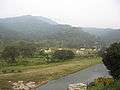 picture of raamganga taken at maasi towards bhikyasen direction
Length:1931km
Ramganga East
| Ramganga East | |
|---|---|
| Basin | |
| Main source | Himalayas- Namik Glacier, Pithoragarh district |
| River mouth | Flows into River Kali |
Another Ramganga called Ramganga East originates from the Namik Glacier in Pithoragarh district of Uttarakhand and flows towards South-East.[1][2] The river is fed by numerous small and big rivers and finally joins river Sarju at Rameshwar near Ghat of Pithoragarh.[1] The Sarju in turn confluences with the Kali (Sharda).[3]
References
- 1 2 Negi, Sharad Singh. Himalayan Rivers, Lakes, and Glaciers. Indus Publishing. p. 115. ISBN 9788185182612. Retrieved 9 November 2016.
- ↑ Rawat, Ajay Singh. Forest Management in Kumaon Himalaya: Struggle of the Marginalised People. Indus Publishing. p. 18. ISBN 9788173871016. Retrieved 9 November 2016.
- ↑ Gulia, K. S. Discovering Himalaya : Tourism Of Himalayan Region (2 Vols.). Gyan Publishing House. p. 84. ISBN 9788182054103. Retrieved 9 November 2016.
Coordinates: 26°28′21″N 80°19′52″E / 26.4725°N 80.3311°E