Ranger, Texas
| Ranger, Texas | |
|---|---|
| City | |
|
Roaring Ranger Museum | |
 Location of Ranger, Texas | |
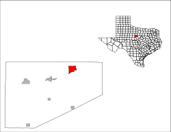 | |
| Coordinates: 32°28′12″N 98°40′36″W / 32.47000°N 98.67667°WCoordinates: 32°28′12″N 98°40′36″W / 32.47000°N 98.67667°W | |
| Country | United States |
| State | Texas |
| County | Eastland |
| Area | |
| • Total | 7.13 sq mi (18.46 km2) |
| • Land | 7.00 sq mi (18.12 km2) |
| • Water | 0.13 sq mi (0.34 km2) |
| Elevation | 1,437 ft (438 m) |
| Population (2010) | |
| • Total | 2,468 |
| • Density | 353/sq mi (136.2/km2) |
| Time zone | Central (CST) (UTC-6) |
| • Summer (DST) | CDT (UTC-5) |
| ZIP code | 76470 |
| Area code(s) | 254 |
| FIPS code | 48-60632[1] |
| GNIS feature ID | 1344793[2] |

Ranger is a city in Eastland County, Texas, United States. The population was 2,468 at the 2010 census.[3] Ranger College, a community college, is the second largest employer in the community.
During the 1920s, Ranger, like nearby Cisco, Eastland, and Desdemona, was a petroleum boomtown. At the time, Ranger had railroad service through the since defunct Wichita Falls, Ranger, and Fort Worth Railroad, acquired by the Wichita Falls and Southern Railroad, one of the properties of Frank Kell, Joseph A. Kemp, and later Orville Bullington of Wichita Falls, Texas. The Wichita Falls and Southern was abandoned in 1954.[4]
Geography
Ranger is located in northeastern Eastland County at 32°28′12″N 98°40′36″W / 32.47000°N 98.67667°W (32.470102, -98.676734).[5] Interstate 20 passes south and east of the city, with access from Exits 349, 351, 352, and 354. I-20 leads east 85 miles (137 km) to Fort Worth and west 65 miles (105 km) to Abilene. Eastland, the county seat, is 10 miles (16 km) to the west.
According to the United States Census Bureau, the city of Ranger has a total area of 7.1 square miles (18.5 km2), of which 7.0 square miles (18.1 km2) is land and 0.1 square miles (0.3 km2), or 1.83%, is water.[3]
Ranger Antique Airfield dates back to 1911. Pilot Amelia Earhart landed at the field in 1931 in her Pitcairn Autogyro. Ranger Airfield has two grass runways: 1/19 - 3400 x 80 ft. and 17/35; 1950 x 60 ft.
Climate
The climate in this area is characterized by hot, humid summers and generally mild to cool winters. According to the Köppen Climate Classification system, Ranger has a humid subtropical climate, abbreviated "Cfa" on climate maps.[6]
Demographics
| Historical population | |||
|---|---|---|---|
| Census | Pop. | %± | |
| 1920 | 16,205 | — | |
| 1930 | 6,208 | −61.7% | |
| 1940 | 4,553 | −26.7% | |
| 1950 | 3,989 | −12.4% | |
| 1960 | 3,313 | −16.9% | |
| 1970 | 3,094 | −6.6% | |
| 1980 | 3,142 | 1.6% | |
| 1990 | 2,803 | −10.8% | |
| 2000 | 2,584 | −7.8% | |
| 2010 | 2,468 | −4.5% | |
| Est. 2015 | 2,464 | [7] | −0.2% |
As of the census[1] of 2000, there were 2,584 people, 989 households, and 616 families residing in the city. The population density was 369.0 people per square mile (142.5/km²). There were 1,214 housing units at an average density of 173.4 per square mile (67.0/km²). The racial makeup of the city was 84.83% White, 6.73% African American, 0.66% Native American, 0.43% Asian, 5.65% from other races, and 1.70% from two or more races. Hispanic or Latino of any race were 13.51% of the population.
There were 989 households out of which 28.0% had children under the age of 18 living with them, 43.7% were married couples living together, 14.7% had a female householder with no husband present, and 37.7% were non-families. 34.5% of all households were made up of individuals and 18.7% had someone living alone who was 65 years of age or older. The average household size was 2.33 and the average family size was 3.00.
In the city the population was spread out with 22.7% under the age of 18, 17.4% from 18 to 24, 20.9% from 25 to 44, 19.4% from 45 to 64, and 19.7% who were 65 years of age or older. The median age was 36 years. For every 100 females there were 97.1 males. For every 100 females age 18 and over, there were 93.8 males.
The median income for a household in the city was $22,500, and the median income for a family was $28,255. Males had a median income of $24,333 versus $15,946 for females. The per capita income for the city was $11,698. About 14.4% of families and 18.3% of the population were below the poverty line, including 19.1% of those under age 18 and 17.8% of those age 65 or over.
Education
The city is served by the Ranger Independent School District and home to the Ranger High School Bulldogs.
Notable people
- Stephen Arterburn, Evangelical Christian author and spokesman
- Bobby Cross, American football player
- Buster Mills, baseball player
- Ted Neeley, actor best known for playing the title role in the film Jesus Christ Superstar
- Bob Smith, American football player
- Eve Southern, actress
- Walter Prescott Webb, eminent Texas, western and Great Plains historian
Photo gallery
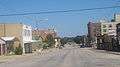 Downtown Ranger
 First American Bank in downtown Ranger
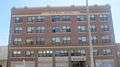 The former Gholson Hotel in Ranger is now an apartment complex.
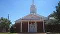 First Baptist Church of Ranger
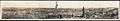 Oil-field boom town of Ranger in 1919
References
- 1 2 "American FactFinder". United States Census Bureau. Retrieved 2008-01-31.
- ↑ "US Board on Geographic Names". United States Geological Survey. 2007-10-25. Retrieved 2008-01-31.
- 1 2 "Geographic Identifiers: 2010 Census Summary File 1 (G001): Ranger city, Texas". American Factfinder. U.S. Census Bureau. Retrieved March 24, 2016.
- ↑ "H. Allen Anderson, "Wichita Falls and Southern Railroad"". tshaonline.org. Retrieved April 19, 2013.
- ↑ "US Gazetteer files: 2010, 2000, and 1990". United States Census Bureau. 2011-02-12. Retrieved 2011-04-23.
- ↑ Climate Summary for Ranger, Texas
- ↑ "Annual Estimates of the Resident Population for Incorporated Places: April 1, 2010 to July 1, 2015". Retrieved July 2, 2016.
- ↑ "Census of Population and Housing". Census.gov. Retrieved June 4, 2015.
Municipalities and communities of Eastland County, Texas, United States | ||
|---|---|---|
| Cities | 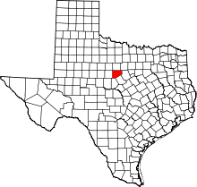 | |
| Towns | ||
| Unincorporated communities | ||
| Ghost towns | ||