Ranrapalca
| Ranrapalca | |
|---|---|
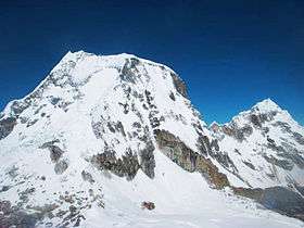 Ranrapalca (on the left) and Ocshapalca (on the right) as seen from the north-east (near the Ishinca glacier) | |
| Highest point | |
| Elevation | 6,162 m (20,217 ft) |
| Coordinates | 9°24′40″S 77°25′00″W / 9.41111°S 77.41667°WCoordinates: 9°24′40″S 77°25′00″W / 9.41111°S 77.41667°W |
| Geography | |
 Ranrapalca Peru | |
| Location | Ancash, Peru |
| Parent range | Andes, Cordillera Blanca |
| Climbing | |
| First ascent | Northeast ridge by W.Brecht et al. - 25 June 1939 [1] |
Ranrapalca[2][3] (possibly from Quechua ranra stony, pallqa bifurcation, division into two parts) is a mountain in the Cordillera Blanca range in the Andes of Peru. It has an elevation of 6,162 m (20,217 ft).[3] It is located in the region of Ancash, east of Ocshapalca.
Climbing
The northeast ridge (normal route) is of intermediate difficulty (rated D range according to the International French Adjectival System). It consists in climbing a steep, rocky ridge from the Ranrapallqa-Ischinca col to the summit snowfields and 6,000 m and then traverse south of the knife edge summit. An easier variant of the normal route consists in avoiding the northeast ridge. From the Ranrapallqa-Ischinca col the summit snowfields can be reached climbing the easy snow slopes on the left of the ridge but this route, albeit slightly easier is more exposed to seracs and loose rocks. Many other routes exist, some of them quite difficult (such as the east ridge and south face, both rated TD+).
Images
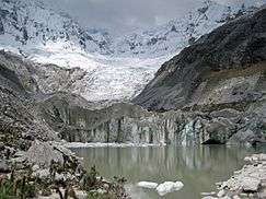 Ocshapalca (on the left) and Ranrapalca (on the right), the Llaca Glacier and the Llaca Lake
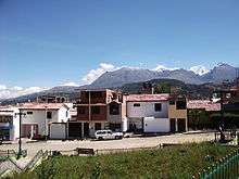 Vallunaraju, Ocshapalca, Ranrapalca (the snow-covered mountains on the right) as seen from Huaraz