Rapides du Cheval Blanc
| Rapides du Cheval Blanc | |
|---|---|
| Type | Regional park |
| Location | Pierrefonds-Roxboro, Montreal |
| Coordinates | 45°30′50″N 73°50′17″W / 45.5139°N 73.8381°WCoordinates: 45°30′50″N 73°50′17″W / 45.5139°N 73.8381°W |
| Area | 14 hectares of forest, flood plain and shoreline |
There are three locations in Quebec, Canada with the name "Rapides du Cheval Blanc". This article is on the rapids between the north side of the Island of Montreal, and the south side of Sainte-Dorothée, Laval.[1]
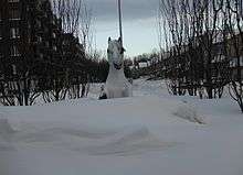
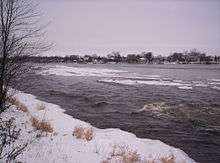
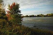
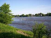
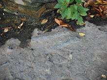
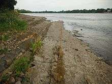
The Rapides du Cheval Blanc,[2] or White Horse Rapids,[3] [4] [5][6] flow between the Island of Montreal, Pierrefonds-Roxboro and Sainte-Dorothée, Laval on the Rivière des Prairies in Quebec. The name also refers to a protected woods, a public city park adjacent to the rapids, and to a fault line underneath the area.[7] The rapids are visible at the public park. The name "Rapides du Cheval Blanc" is applied to a large area.
History
The name Whitehorse or Cheval Blanc comes from several legends, one of which is 18th-century legend of a white horse that would emerge from the Rivière des Prairies, and terrorize villagers and ravage crops.[8] Another legend says a horse was pulling a cart on a ferry across the river to Île Bizard when the cable connecting the ferry to the shore broke and it drifted downstream. At the height of the rapids, the horse escaped.[9] [10] Another legend is that of a white horse that carried the materials for the construction of the Church of Sault-au-Récollet jumped aboard a boat in the middle of the rapids.
The land being next to the Rivière des Prairies is subject to spring flooding[11][12][13][14][15] and has flooded many times in the past.
Ownership of the River
The river is owned by both the Federal and Provincial governments. The Federal government, Fisheries and Oceans Canada polices the water, the Provincial polices the earth, the bottom of the river and the north and south shorelines.[16] Floating buoys are placed in the river during the summer to aid boat navigation. The river cleanliness is usually good according to the RSMA (Réseau de suivi du milieu aquatique) water testing that is done weekly during warm weather. Rapides du Cheval Blanc is numbered RDP-180.[17] The river temperature can be found on the RSMA (Réseau de suivi du milieu aquatique) water quality report, it peaks at 25 degrees Celsius in the months of July and August.
Ownership of the Land
The original owners of the land were of course the Aboriginal peoples and the Algonquin people. Explorers from France named the land New France and the parish of Sainte- Geneviève was founded in 1741.[18] Treaty of Paris (1763) ceded Canada and most of New France to Britain after the Seven Years' War.[19] In 1775-1776 the Island of Montreal was under attack from America, Fort Senneville was destroyed in 1776. Treaty of Paris (1783) ended the American Revolutionary War. The nation of Canada formed July 1, 1867.
Historical maps show boundary lines of the farmers fields using the Seigneurial system with names associated to the land.[20] From East to West the names on the Henry Whitmer Hopkins map (year 1879) are
- Lot 49 Jos Legault
- Lot 51 M. Lelande (Lalande)
- Lot 52 P. Legault
- Lot 55 N. Lelande (Lalande) Where the public park overlooks the rapids is today. The north end of the street "Riviera".
- Lot 62 Jos. Legault
- Lot 67 Berthiaume
- Lot 68 Jos. Brunet
- Lot 75 M. Langerin
- Lot 76 Jos. Langerin
- Lot 77 N. Cardinal
- Lot 86 Cardinal
- Lot 87 Richermois
- Lot 92 Jos. Theoret
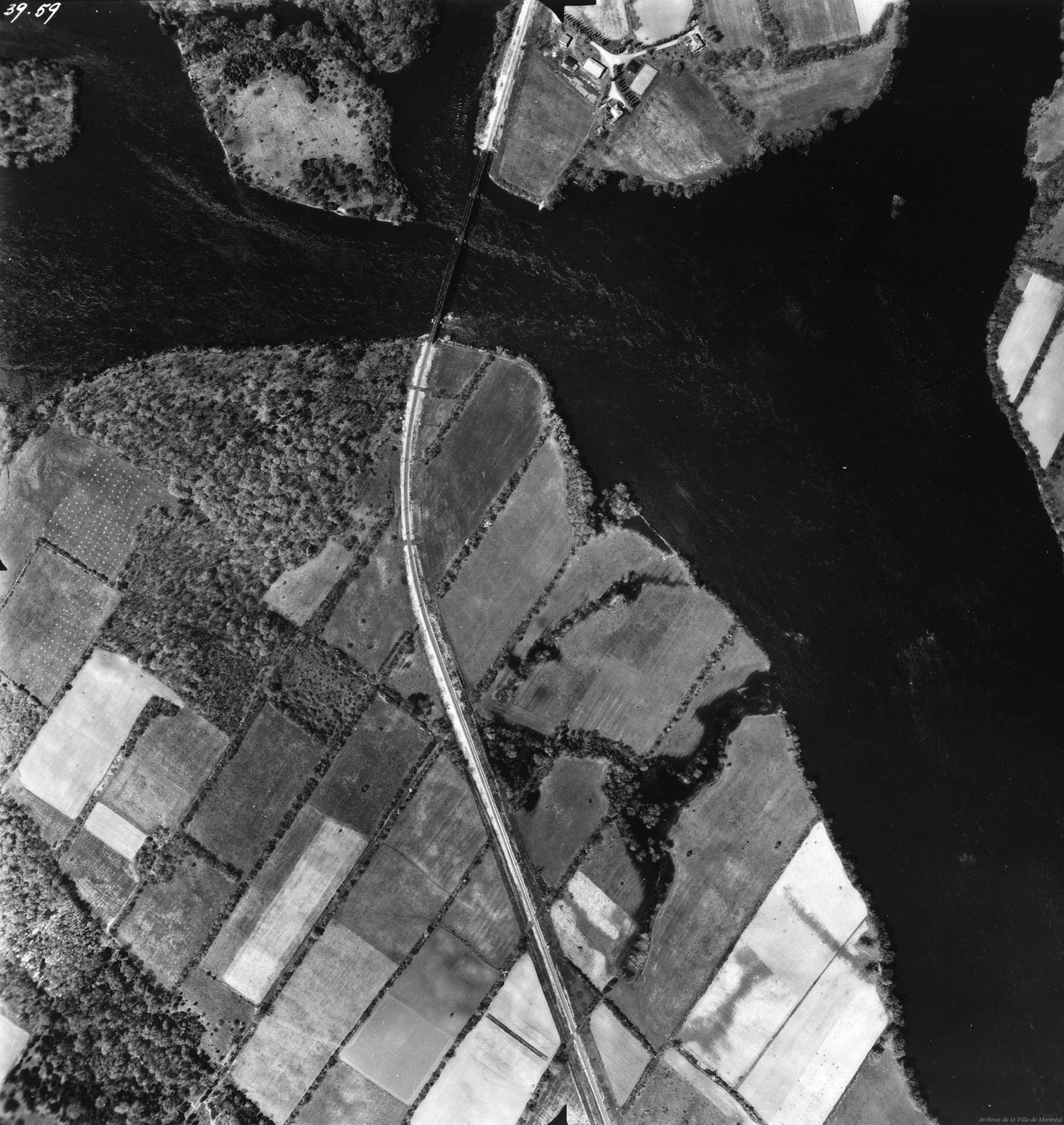
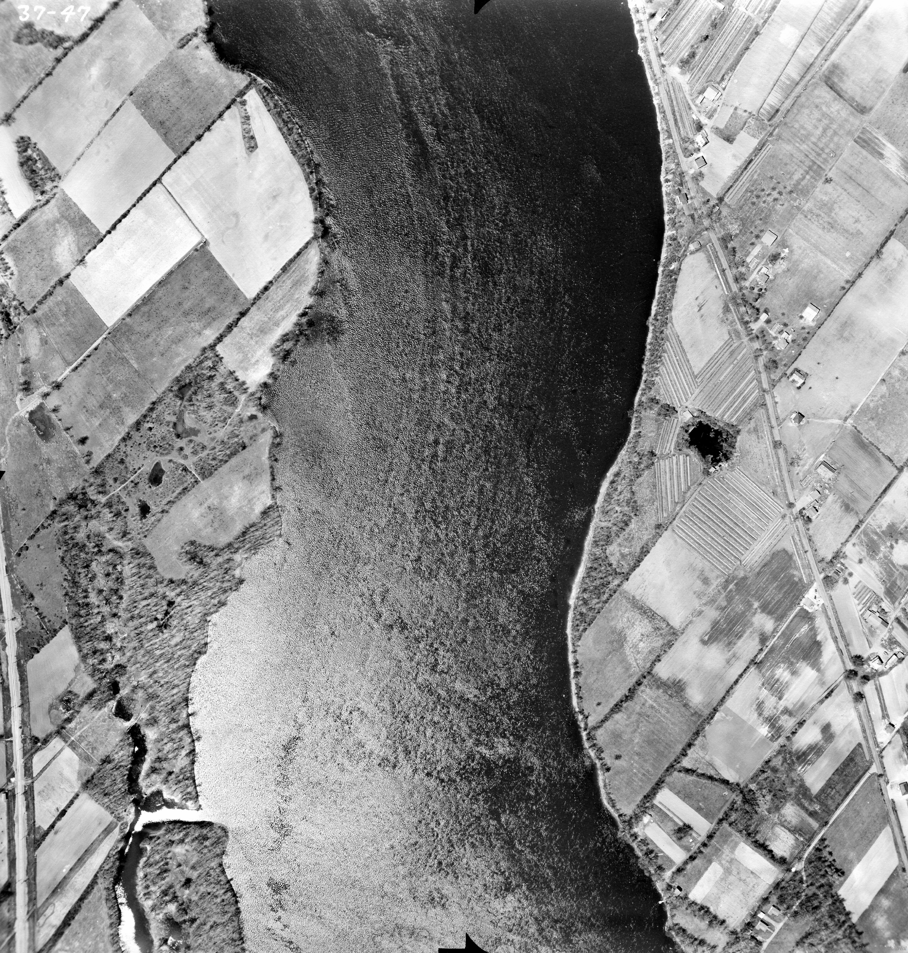
Aerial photographs of 1947[21][22] show that the Cheval Blanc land was agricultural at that time . When the Deux-Montagnes (original name Canadian Northern Railway) railway was built through the land during the years 1912-18, many fields were cut off from their original parcel of farmland, resulting in triangle shaped properties.
Presently on the undeveloped lots or properties, the Habitant-farmers boundary lines still exist and are visible as 3 feet wide by 3 feet tall stone walls, also many of the farmers apple trees can still be found in the woods.
Residential development began to replace the farmland in 1953.[18]
The location in the river was officially named in 1968 by the Gouvernement du Québec and Natural Resources Canada.[1][23]
The land was being considered as a place for a million dollar apartment building in 1972.[24]
A petition of George Boutellier that had over a thousand names was presented to then Mayor Eddie Lalande[25] in an attempt to protect the land from development in 1972, but it was ignored.[26]
The land was being considered as a "Promenade" park as early as 1974.[27]
According to the Gouvernement du Québec and Natural Resources Canada the public park was created in 1997 on the site of a former sewage treatment plant. The sewage plant was on Lot 67 and Lot 62.[28][29][30][31][32][33]
The current nature park, a further expansion of the 1997 park, was finally created in 2009.[34]
In December 2015 the sum of $3,431,280 was paid by Réal Ménard the Montreal Executive Committee member responsible for green spaces, to the owner of Lot 1 171 908 on behalf of the city of Montreal. The land located at 1 171 908 was originally designated unbuildable floodplain valued at $1.00, then rezoned , then valued at $452,600 in 2014-2016 .[35]
A significant portion of the land that is close to 5th Avenue North has construction debris on the property. After sunset, in the months of June and July firefly's can be seen from the bicycle path that is west of 5th Avenue North.[36]
Wildlife
Wild animals that can be found on the land near the rapids are rabbits, squirrels, snakes, chipmunks, turtles, cardinals, seagulls, sandpipers, herons, ducks, geese, chickadees and finches.
Development
The railway acted as a barrier to traffic, prevented the easy commercial development of the land.[37] The land was also a designated flood-zone, it often floods in the spring. The river (Rivière des Prairies) water was badly polluted in the past so this discouraged development. The city of Montreal has given Cheval Blanc the designation of RDP 180 and tests the water quality during the summer(RSMA Le Réseau de suivi du milieu aquatique).[38] Land developers are currently trying to make money building on the "new" riverfront property.[39][40] In the past, landfill was added to the land to raise the lands height relative to the river height, so buildings could be built .
Residents and environment groups have asked for preservation of the land.[41][42] Condominium development is planned for a section of land on the far eastern part of Rapides du Cheval Blanc woods, across from Roxboro island. The traffic from the Condo's is to be connected to 5th Avenue North street.
The land developers received permission from the Quebec Environment Department for a derogation that de-zoned the Pierrefonds land as unbuildable flood plain.[43]
The streets "Rue du Sureau", "Rue du Celtis", "Rue de L Achillee", and "Rue de L Armoise" were constructed in 2009 for the new buildings just west of the street Rue Riviera. East of Rue Riveria is a northern extension of "Boulevard des Sources" and "Rue Debours" which were constructed in 2004.
The former Mayor of Pierrefonds-Roxboro, Mme Monique Worth had in October 2004 bought a property at 5200 Sources Blvd. in the newly developed Cheval Blanc land for $180,538 and sold it April 4, 2005, for $235,000 for a profit of $54,000.[44][45]
References
- 1 2 Les rapides du Cheval Blanc 1968-12-05 toponymie.gouv.qc.ca
- ↑ Rapides du Cheval Blanc, Quebec Map
- ↑ "Island of Montreal, Quebec.("White Horse rapids" is written)" (PDF). Natural Resources Canada, Copyright, Canada, 1916, Stansfield, J www.geogratis.gc.ca/api/en/nrcan-rncan/ess-sst/07493d8a-9489-5752-b77e-62bbc416b636.html.
- ↑ "Gordon & Gotch's Map of the Island of Montreal ("White Horse Rapids" is written at H-10)" (PDF). Copyright, Canada, 1924, Albert E. Dumont.
- ↑ Library and Archives Canada. URL source for the Gordon & Gotch's/Copyright 1924, Albert E. Dumont. Map
- ↑ "Soil Map of Montreal-Jesus-Bizard Islands. ("White Horse rapids" is written)". Copyright, Experimental Farms Service Canada Department of Agriculture, 1952. sis.agr.gc.ca/cansis/publications/surveys/pq/pq41/index.html.
- ↑ "Geology of the West Island: Pride of Place by David Wise" (PDF). mcgill.ca.
- ↑ "Pierrefonds white horse to ride again". West Island Chronicle. July 27, 2009. Retrieved April 20, 2011.
- ↑ Beauregard, Ludger (1968). Toponymie de la région métropolitaine de Montréal. Ministry of Lands and Forests of Quebec. p. 47. OCLC 5935170.
- ↑ Toponymie de la région métropolitaine de Montréal.page 49 of 223 of the PDF
- ↑ "Roxboro Resident, Mayor Differ On Flooding Cause". The Montreal Gazette. Dec 27, 1957.
- ↑ "Roxboro's Mayor Boll clarifies flood problem". The North Shore News. April 5, 1973.
- ↑ "Flood control up to government". The North Shore News. August 2, 1973.
- ↑ "Roxboro flood victims retain lawyer". The North Shore News. October 24, 1974.
- ↑ "Roxboro racing to bolster spring flood defenses". The North Shore News. March 10, 1977.
- ↑ "Quebec Ok`s Pierrefonds` dredging scheme". September 14, 1978.
- ↑ Réseau de suivi du milieu aquatique.
- 1 2 page 19 (29 of 113) http://ville.montreal.qc.ca/pls/portal/docs/PAGE/ARROND_PIR_EN/MEDIA/DOCUMENTS/MASTER_PLAN_CSLSD.PDF
- ↑ Allaire, Gratien (May 2007). "From "Nouvelle-France" to "Francophonie canadienne": a historical survey". International Journal of the Sociology of Language. 2007 (185): 25–52. doi:10.1515/IJSL.2007.024.
- ↑ "Henry Whitmer Hopkins year 1879 "Parishes of Bizard, Ste Ann, Ste Genevieve, and Pointe Claire". Map. Bibliothèque et Archives nationales du Québec.
- ↑ Archives de Montréal archivesdemontreal.com/greffe/vues-aeriennes-archives/
- ↑ Archives de Montréal archivesdemontreal.com/greffe/vues-aeriennes-archives/
- ↑ "Rapides du Cheval Blanc" Natural Resources Canada
- ↑ "$4,000,000 high-rise apartment project planned for Pierrefonds riverfront" North Shore News May 18, 1972
- ↑ "200 Year old Lalande homestead falls to wrecker" North Shore News. August 8, 1968
- ↑ "Delegation Wins Delay On Apartment Project" North Shore News. June 8, 1972
- ↑ "A view of Pierrefonds looking south" North Shore News March 28, 1974
- ↑ Parc des Rapides-du-Cheval-Blanc 1997-03-25
- ↑ "The North Shore at a Glance". The North Shore News. April 29, 1965.
- ↑ North Shore News November 30, 1972 "Pierrefonds fills in open sewer"
- ↑ North Shore News November 30, 1972 "Angry appeals for intervention"
- ↑ North Shore News July 27, 1962 "Pierrefonds to construct third sewage treatment plant"
- ↑ "Parc des Rapides-du-Cheval-Blanc" Natural Resources Canada. Named 1997-03-25
- ↑ "Montréal crée un nouveau parc-nature". CNW newswire. September 25, 2009.
- ↑ ASSEMBLÉE ORDINAIRE DU CONSEIL MUNICIPAL VERSION 2. 14 December 2015. Page 1417 of 2023 of the PDF
- ↑ "City of Montreal acquires land to increase Rapides-du-Cheval-Blanc Nature Park". The Suburban author Kevin Woodhouse. December 9, 2015.
- ↑ "Sources Blvd. Level Crossing Ordered". August 28, 1969.
- ↑ Service de l'environnement Réseau de suivi du milieu aquatique Localisation des stations d'échantillonnage de l'eau en rive
- ↑ "Project Archipel: Is it a boon or boondoggle?". June 21, 1982.
- ↑ Projet Montréal accuse le maire Tremblay d'avoir fait perdre 4 M$ à la Ville, Avril 28 2011 Radio-Canada
- ↑ "Quebec Liberals getting greener". July 17, 2006.
- ↑ "Le sort des rapides du Cheval-Blanc bientôt fixé". December 15, 2006.
- ↑ "City once owned land it bought". November 4, 2006.
- ↑ [ http://www.newswire.ca/en/story/814917/la-ville-de-montreal-a-perdu-4-m-dans-un-echange-de-terrains "La Ville de Montréal a perdu 4 M$" Newswire April 28, 2011]
- ↑ "La transaction s'est faite avec le promoteur Hershey Rosen" André Noël La Presse April 28 2011
External links
- From the Ville Montreal, a website of the Écoterritoire of Cheval Blanc (in French) Rapides du Cheval Blanc
- From the Ville Montreal, the PDF of the Cheval Blanc ecoterritory (in French) "Les 10 écoterritoires"
- From the Ville Montreal, the PDF map of the Cheval Blanc area "Le Corridor Ecoforestier Des Rapides Du Cheval Blanc"
- From the Ville Montreal, (2004) Cheval Blanc is on page 26 of The PDF named "Policy on the protection and enhancement of natural habitats"
- From the Ville Montreal, (Feb 2013) the Cheval Blanc ecoterritory is in of The PDF named "Master plan for sports and recreation facilities"
- From the Ville Montreal, Cheval Blanc is named RDP 180 in this river water quality reporting website "Suivi de la qualité bactériologique des cours d'eau à Montréal"
Internet Newspaper articles
- Newspaper La Ville de Montréal a perdu 4 M$ dans un échange de terrains
- Pierrefonds - Le projet immobilier des rapides du Cheval Blanc est amputé de moitié. François Cardinal . 24 septembre 2002 (French)
- L'arrondissement de Pierrefonds veut acheter, pour $650,000 un terrain marécageux. André Beauvais. 06/06/2007 (French)
- "Citizens denounce proposal". Andy Blatchford. December 20, 2006
- Tensions build over Roxboro high-rise project. Raffy Boudjikanian. November 24, 2009
- "City won't disclose purchase price". Linda Gyulai. February 14, 2011
- "A Quebec court has upheld a zoning bylaw". Cheryl Cornacchia. April 11, 2012
Other
- The Green coalition website of Cheval Blanc Rapids
- Lewis Poulin log of lot 1 171908
- PDF on the Geology of Montreal, citing the Cheval Blanc Rapids Fault