Transportation in Montreal
Montreal is a transportation hub for eastern Canada, with well-developed air, road, rail, and maritime links to the rest of Canada, as well as the United States and Europe.
Air
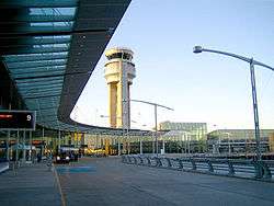
Montreal has two international airports, one for passenger flights only, and the other for cargo. Montréal-Pierre Elliott Trudeau International Airport (also known as Dorval Airport) in the City of Dorval serves all commercial passenger traffic and is the headquarters for Air Canada[1] and Air Transat.[2] To the north of the city is Montréal-Mirabel International Airport in Mirabel, which was envisioned as Montreal's primary airport but which now serves cargo flights along with MEDEVACs and general aviation as well as some passenger services.[3][4][5][6][7] In 2014, Montreal-Trudeau was the fourth busiest airport in Canada by both passenger traffic and by aircraft movements, behind Toronto Pearson, Vancouver and Calgary. In 2014, the airport handled 14.8 million passengers,[8][9] and 225,219 aircraft movements.[10] With 61% of its passengers being on non-domestic flights it has the largest percentage of international flights of any Canadian airport.[9] Trudeau airport is served by 40 carriers to over 100 destinations worldwide.[11] Airlines servicing Trudeau offer flights to Africa, Central America, the Caribbean, Europe, the United States, Mexico and other destinations within Canada. It is the only Canadian airport that offers non-stop service to Africa and it also contains the largest duty-free shop in North America.[12]
Other airports in the Montreal area serve military and civilian use.
Public transportation to Montréal-Pierre Elliott Trudeau International Airport is provided by the Société de transport de Montréal's bus line 747.[13]
Surface Transportation
Rail
Intercity passenger service
VIA Rail, which is headquartered in Montreal, provides rail service to other cities in Canada, particularly to Quebec City, Ottawa, and Toronto with several trains daily on its Quebec City-Windsor Corridor.
Amtrak, the US national passenger rail system, also provides service to Montreal, operating its Adirondack daily between Montreal and New York City.
All intercity trains operate out of Central Station. VIA and Amtrak trains also stop at several suburban stations, the largest of which is at Dorval, adjacent to the airport.
Regional passenger service
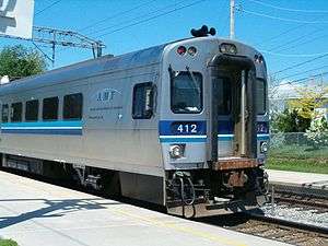
Regional passenger train service, geared largely to daily commuters to Montreal's central business district, is operated by the Agence métropolitaine de transport. Six train lines operate out of the Lucien-L'Allier and Central stations with Parc, Vendome, De La Concorde, and Sauvé as secondary stations. These facilities are all stops on the Metro system as well. Lines are operated under contract by Canadian National and Canadian Pacific. In some cases, AMT owns the track and infrastructure.
Freight service
Canadian Pacific Railway (known as CP or the CPR), now headquartered in Calgary, Alberta, was founded here in 1881.[14] Its corporate headquarters occupied Windsor Station at 910 Peel Street until 1995.[15] With the Port of Montreal kept open year round by icebreakers, lines to Eastern Canada became surplus, and now Montreal is the railway's eastern and intermodal freight terminus.[16] CPR connects at Montreal with the Port of Montreal, the Delaware & Hudson Railway to New York, the Quebec-Gatineau Railway to Quebec City and Buckingham, the Central Maine and Quebec Railway to Halifax, and CN Rail. The CPR's flagship passenger train, The Canadian, once ran daily from Windsor Station to Vancouver. CP's passenger services were transferred to VIA Rail Canada in 1978.
Montreal-based Canadian National Railways (known as CN, or less-commonly, the CNR) was formed during in 1919 by the Canadian government following a series of country-wide rail bankruptcies. CN was formed from the lines of the Grand Trunk, Midland and Canadian Northern Railways, and has risen to become CPR's chief rival in freight carriage in Canada.[17] Like the CPR, CN transferred passenger services to VIA Rail Canada, now a crown corporation, but once part of CN itself.[18]
Public Transit
Greater Montreal is served by a number of public transit providers.
Société de transport de Montréal
The STM serves the Island of Montreal as well as islands of Bizard, des Soeurs, Notre Dame, and Sainte-Helene. The bus network consists of 165 daytime and 20 night-time service routes. STM also provides paratransit and limited wheelchair-accessible buses.[19]
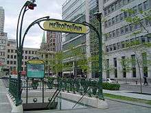
Metro
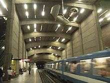
The Montreal Metro, a subway system, was inaugurated in 1966 and today has 68 stations spread out along its four lines.[20] All but five stations are on the Island of Montreal and in STM's territory. Each station was designed by different architects with individual themes and features original artwork, and the trains themselves run on rubber tires, making the system quieter than most.[21] The project was initiated by Montreal Mayor Jean Drapeau, who would later bring the Summer Olympic Games to Montreal in 1976. The Metro system has long had a station on the South Shore in the city of Longueuil, and has only recently been extended to the city of Laval, north of Montreal with 3 new stations.[22]
Since Sunday, February 7 the new Azur metro cars are accessible to the users, one of the many features of these new cars is that they can accommodate up to 8% more passengers than the current models who have been running since inauguration of the metro.[23]
The city of Montreal has announced plans to convert its entire fleet of buses over to all-electric by 2025.[24]
Société de transport de Laval
The city of Laval, on neighboring Île Jésus, is served by the Société de transport de Laval (STL). The STL runs 40 routes, many of which connect to one of the three Laval Metro stations or to the AMT train station at Sainte-Dorothée. Other bus routes connect to Metro stations on the Island of Montreal, including Côte-Vertu and Henri-Bourassa.
Réseau de transport de Longueuil
Service to the densest part of Montreal's South Shore is provided by the Réseau de transport de Longueuil (RTL). RTL's numerous routes serve the Terminus Centre-Ville, the Longueuil Metro station, and several AMT train stations.
Summertime ferry
From late spring to early autumn, pedestrian/cyclist ferry service links the Old Port of Montreal, Saint Helen's Island, and the South Shore communities at Longueuil, a distance of 5.5 kilometres (3.4 mi).
Mid-July 2016, a proposal was suggested by a competing riverboat operator at establishing summertime weekday rush-hour pedestrian ferry service between the downstream, northeastern, outermost borough of Rivière-des-Prairies-Pointe-aux-Trembles and the Old Port, an approximate distance of 21 kilometres (13 mi).
Road Network
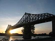
Like many major cities, Montreal has a problem with vehicular traffic congestion, especially from off-island suburbs such as Laval on Île Jésus, and Longueuil on the south shore. The width of the Saint Lawrence River has made the construction of fixed links to the south shore expensive and difficult. There are only four road bridges along with one road tunnel, two railway bridges, and a Metro line. The far narrower Rivière des Prairies, separating Montreal from Laval, is spanned by eight road bridges (six to Laval and two directly to the north shore).
On the Island of Montréal motorists are forbidden from turning right while facing a red traffic signal, a move permitted elsewhere in the Province of Quebec.
Limited-access highways (Autoroutes)
The island of Montreal is a hub for the Québec Autoroute system, and is served by Québec Autoroutes A-10 (known as the Bonaventure Expressway on the island of Montreal), A-15 (aka the Decarie Expressway south of the A-40 and the Laurentian Autoroute to the north of it), A-13 (aka Autoroute Chomedey), A-20, A-25, A-40 (part of the Trans-Canada Highway system, and known as "The Metropolitan" or simply "The Met" in its elevated mid-town section), A-520, and A-720 (aka the Ville-Marie Autoroute). Many of these Autoroutes are frequently congested at rush hour. However, in recent years, the government has acknowledged this problem and is working on long-term solutions to alleviate the congestion. One such example is the extension of Quebec Autoroute 30 on Montreal's south shore, which will serve as a bypass.[25] Today's existing highways have been planned in the 1960s as part of a grid like transport system.
Street grid system
Since Montreal is on an island, the directions used in the city plan do not precisely correspond with compass directions, as they are oriented to the geography of the island. North and south are defined on an axis roughly perpendicular to the St. Lawrence River and the Rivière des Prairies: North is towards the Rivière des Prairies, and south is towards the St. Lawrence. East (downstream) and west (upstream) directions are defined as roughly parallel to the St. Lawrence River and the Rivière des Prairies, despite the fact that both rivers flow from the southwest to the northeast.
Saint Lawrence Boulevard, also known as "The Main," divides Montreal into east and west sectors. Streets that cut across Saint Laurent Boulevard undergo a name change, in that Est or Ouest are appended to their names. Streets that do not cross the Main do not generally contain a cardinal direction at the end of their names.[26] Address numbering begins at one at Saint Lawrence Boulevard. The numbers increase as you move away from the boulevard. On north-south streets, house numbers begin at the Saint Lawrence River and the Lachine Canal and increase to the north. Odd numbers are on the east or north sides of the street, with even numbers on the west or south sides. Numbered streets generally run north and south, and the street numbers increase to the east.
Moreover, the addresses are on a grid-axis system, as in many North American cities. Streets generally retain their grid position throughout their course, even if they are slightly diagonal. For example:
- Sherbrooke Street, which runs "east-west" is 3400 (north of the Saint Lawrence), so a house on the north-east corner of Sherbrooke St. would theoretically be numbered 3401, and on the north-west 3400.
- Saint Hubert Street, which runs "north-south" is 800 East, so a house on the north-east corner of St-Hubert St, would be 801 (or 801 East if the street crosses Saint Lawrence Boulevard), and a house on the south-east corner would be 800 East.
- Peel Street, which runs "north-south" is 1100 West, so a house on the north-west corner of Peel St, would be 1101 (or 1101 West if the street crosses Saint Lawrence Boulevard), and a house on the south-west corner would be 1100 West.

An anomaly is that zero is the Saint Lawrence River and the Lachine Canal, so address numbers south of the canal begin at zero at the river, then increase toward the canal, and the canal resets the address grid back to zero. There are only two streets (Atwater and Charlevoix) that cross the canal without changing names, so that addresses south of the canal add a 0 (zero) before the number to act as a "negative" (though they still increase northward and respect the grid of the streets parallel to them). Therefore, 0400 Charlevoix St. is south of the canal, and 400 north of it.
Other grid axes:
- North-south streets, east side: St-Denis 400, Amherst/Christophe-Colomb 1100, Papineau 1800, De Lorimier 2100, Pie-IX Blvd 4100, Honoré-Beaugrand 8000, St-Jean-Baptiste Blvd 12000, Rousselière 14000.
- North-south streets, west side: Park Avenue 300, Peel 1100, Atwater 3000, Décarie 5300, Cavendish 6500.
- East-west streets: Notre-Dame 500, René-Lévesque Blvd 1150, Sainte-Catherine 1400, Ontario 2000, Sherbrooke 3400, Mont-Royal Avenue 4500, St-Joseph Blvd 5000, Beaubien 6500, Jean-Talon 7200, Jarry 8100, Henri-Bourassa 10700, De Salaberry 12000. Gouin Blvd, which follows the shore of Rivière des Prairies, is too crooked to have a constant grid reference.
The grid-axis system was introduced by the City of Montreal in the mid-1920s, but was not generally adopted by neighboring towns. Most on-island suburbs or boroughs merged recently on the west side of the island still have separate numbering systems, though most streets that start in the 9 original boroughs continue the Montreal numbering beyond its old borders. The highest address in Montreal is 23000 Gouin Boulevard West in the borough of Pierrefonds.
Street naming
Most streets in Montreal do not change name throughout their course, respecting their grid axis. Streets such as Saint Laurent Boulevard, Papineau Ave., De Lorimier Ave. and Pie-IX Blvd. have a foot in both rivers, and some streets re-commence despite gaps or interruptions. There are a few notable exceptions which continue for historical reasons. A few north-south streets which begin in Old Montreal change name at Saint Antoine Street (formerly Craig Street), site of the former city wall (Saint-Pierre → Bleury → Park Avenue, Bonsecours → Saint-Denis). Only one street changes name many times: McGill Street → Square-Victoria Street → Beaver Hall Hill → Frère-André Place → Phillips Place → Phillips Square → Aylmer St.
According to the rules of the Commission de toponymie du Québec, the French-language form of street names is the only official one, and is to be used in all languages: e.g. chemin de la Côte-des-Neiges; rue Sainte-Catherine; côte du Beaver Hall. Most English speakers, however, use English generic equivalents such as "street" or "road", as do English-language media such as the Montreal Gazette. Officially bilingual boroughs have the right to use such names in official contexts, such as on street signs. In the past, a number of streets had both English and French names, such as "avenue du Parc" or "Park Avenue", "rue de la Montagne" or "Mountain Street", "rue Saint-Jacques" or "Saint James Street". Some of these names are still in common colloquial use in English, and perpetuated by the tourism industry. Many streets incorporate an English specific name into French, such as "chemin Queen Mary", "rue University", "avenue McGill College". There are also a few cases where two names are official, such as "chemin du Bord-du-Lac/Lakeshore Road".
In English, the pre-Francization names are still commonly used, thus, although only the French is 'official', in English one often hears names such as Park Avenue, Mountain Street, Saint Lawrence Boulevard, Pine Avenue, Saint John's Boulevard etc. Canada Post accepts the French specific with English generic, as in "de la Montagne Street" or "du Parc Avenue", although many such forms are never used in speaking. Another anomaly that typifies this kind of mixed heritage and history is René Lévesque Boulevard. Once called "Dorchester Boulevard" in its entirety, this long east-west street was renamed for Quebec former nationalist Prime Minister René Lévesque, except for sections that run through the very Anglophone city of Westmount. However, the entire street is still sometimes referred to as "Dorchester."
It is useful to note that, in Montreal as in other cities, the generic is usually omitted in either language, so one would simply talk of Park (or Du Parc), Mountain (or De la Montagne), Saint Lawrence (or Saint Laurent), University, McGill College, Doctor Penfield, or Fairmount. This is mainly because a specific is almost never given to two streets. If duplication exists, they are always in different boroughs or towns and are retained for historical reasons. For example, Montreal's present 19 boroughs have 6 streets named "Victoria" (2 streets, 2 avenues, one court, and one square), and 9 more in on- or off-island suburbs. In recent years Montreal and most of its suburbs have dispensed entirely with such generic and linguistically fraught terms on their street signage.
Bicycle
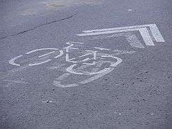
The City of Montreal introduced the Bixi Montreal bicycle share system May 2009, in an effort to encourage locals and tourists to make use of the city's already well-established network of bike paths.[27] The rental bicycles are available from depots located throughout the city, where bikes can be rented from automated stations using a credit card.[28] BIXI (a combination of BIcycle and taXI)[29] estimates that by 2009, 2,400 bicycles will be deployed at 300 depots throughout the metro area.[30] Time Magazine named the bike rental system #19 in Time's Top 50 Inventions of 2008.[31] Bike rentals are also available at the Old Port of Montreal, as well as quadricycles, inline skates, children trailers, and Segways. The system was created to offer an attractive and easy-to-use option that complements existing public transportation networks for those seeking an urban alternative to traditional fuel-powered vehicles.[32]
Cars
For people who need a car for a short term, Montreal has many services to offer among auto sharing or car rental.
If you are looking for a car-sharing company, Communauto is the most popular one. Amigo Express is online platform which allows you to find a lift to any destination in Quebec.
If you need a car for a road trip or another specific need, Hertz, Avis Budget and similar companies have branches in Montreal.
Pay attention if you need to park in Montreal, it is not that easy to find the right place and the right moment, you will also probably have to pay your parking, please refer to the traffic rules.
Marine
The region of Montreal is centred upon the Island of Montreal, part of an archipelago in the Saint Lawrence River. As a result, marine transportation has been integral to the region's history. The Port of Montreal is one of the largest inland ports in the world.[33]
Montreal also sits at the head of the Saint Lawrence Seaway, a waterway that allows ocean-going vessels to travel as far as Lake Erie and beyond. The Seaway replaced the earlier Lachine Canal which was the first facility that allowed boats to bypass the Lachine Rapids.
References
- ↑ aircanada.com - About Air Canada - Corporate Profile
- ↑ Air Transat
- ↑ CTV.ca | Mirabel airport bids final passengers farewell
- ↑ It's liftoff for AirMédic ambulance
- ↑ Mirabel redécolle
- ↑ Hélibellule fleet
- ↑ Hélibellule fait revivre le transport des passagers à Mirabel Archived March 15, 2008, at the Wayback Machine.
- ↑ http://www.calgaryherald.com/Business/loses+title+third+busiest+airport+expects+further+traffic+decline/1499974/story.html
- 1 2 Aéroports de Montréal Passenger Statistics
- ↑ TP141 - Aircraft Movement Statistics
- ↑ "Welcome to Montréal-Trudeau". Aéroports de Montréal. Retrieved 2009-03-26.
- ↑ "Aer Rianta International: Worldwide Locations > Americas > Montreal". Aer Rianta International. Retrieved 2008-02-04.
- ↑ http://www.stm.info/English/info/a-747.htm
- ↑ "A Brief History". General Public. Canadian Pacific Railway. Archived from the original on 2008-03-27. Retrieved 2008-08-02.
- ↑ Nemeth, Mary; Liz Warwick (December 4, 1995). "CP Rail Leaves Montreal". The Canadian Encyclopedia. Retrieved 2008-08-01.
- ↑ "Where We Ship". Customers. Canadian Pacific Railway. Retrieved 2008-08-02.
- ↑ "Birth of Canadian National 1916-1923". Canadian National History. Canadian National Railway. Retrieved 2008-08-02.
- ↑ "Profits and Passengers - 1960-1979". Canadian National History. Canadian National Railway. Retrieved 2008-08-02.
- ↑ "The Bus Network: All Over Montreal" (PDF). Société de transport de Montréal. 2004. p. 4. Retrieved 2008-08-03.
- ↑ Plan du métro de Montréal
- ↑ Giniger, Henry (November 22, 1981). "WHAT'S DOING IN MONTREAL". New York Times. p. 2. Retrieved 2008-08-03.
- ↑ "Premier cuts ribbon on Metro extension to Laval" (PDF). Montreal Gazette. April 26, 2007. Retrieved 2008-08-03.
- ↑ http://www.stm.info/en/about/major_projects/azur-metro
- ↑ http://green.autoblog.com/2010/05/24/montreals-bus-fleet-of-1-300-plus-going-all-electric-by-2025/
- ↑ "The completion of Autoroute 30". Objectives. Transports Québec. August 1, 2008. Retrieved 2008-08-03.
- ↑ "Montreal: Getting to Know : Orientation". Frommers. Retrieved 2008-08-03.
- ↑ "Le r seau cyclable montr alais" (in French). V lo Qu bec. Retrieved 2007-08-02.
- ↑ Sherwood Stranieri (2008-07-03). "Montreal's New Bicycle Rental Program". Using Bicycles. Retrieved 2008-07-27.
- ↑ "Public Bike System". Stationnement de Montreal. 2008. Retrieved 2008-07-27.
- ↑ "Montreal to get first self-serve bike rental system". Montreal Gazette. June 10, 2008. Retrieved 2008-08-03.
- ↑ "Best Inventions Of 2008". Time. 2008-10-29. Retrieved 2010-05-26.
- ↑ Présentation sur le site du stationnement de Montréal
- ↑ "Gateway to North America". Port of Montreal. Retrieved 2011-11-21.
External links
- MontrealRoads.com by Steve Anderson (English)