Ratoath

| Ratoath Ráth Tó | |
|---|---|
| Town | |
|
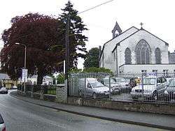
Ratoath – Holy Trinity church | |
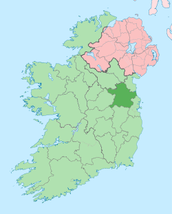
 Ratoath Location in Ireland | |
| Coordinates: 53°30′22″N 6°27′47″W / 53.506°N 6.463°WCoordinates: 53°30′22″N 6°27′47″W / 53.506°N 6.463°W | |
| Country | Ireland |
| Province | Leinster |
| County | County Meath |
| Elevation | 90 m (300 ft) |
| Population (2011)[1] | |
| • Urban | 9,043 |
| Irish Grid Reference | O016519 |
Ratoath (Irish: Ráth Tó, meaning "Tó's ringfort")[2] is a town in the barony of the same name in County Meath, Ireland. The town is centred on the point where the R125 and R155 regional roads meet. In the 1996 census, the population was recorded as 1,061. In the 2006 census, it was 7,249. By 2011 the population reached 9,043. The Broad Meadow River (Irish: An Gabhair) flows through the town.
Ratoath is a commuter town with most of its adult population commuting to Dublin to work. More than three quarters of the population travelled to work by car. In 2011 10.9% of the workforce was unemployed compared to the national average of 19%. This may be due to the small percentage of the Ratoath workers employed in the construction sector, with Ratoath having more people than average from higher socio-economic classes. Social class A, employers and managers constitute 717 of the 2,751 households.[3] Ratoath has its own Secondary school known as Ratoath College.
Just outside the town is the horse racing track Fairyhouse racecourse, where the Irish Grand National is held.
Ratoath gives its name to a village, a townland, a parish, an electoral division and to a barony. The derivation or meaning of the word is uncertain. Two alternative Irish forms are cited: Ráth-Tógh and Ráth-Tábhachta. These placenames occur in Irish manuscripts and scholars say that the writers were referring to Ratoath. Evidently they were trying to give a phonetic rendering of a name that was unfamiliar to them. Mruigtuaithe occurs in the Book of Armagh as the name of one of these places in Meath where Saint Patrick founded a church and Eoin MacNeill identifies it as Ratoath. If this is correct it would seem that the second portion of the word comes from the Irish word tuath which means a territory belonging to a family or sept. Mruig means a grazing plain. Ráth is the Irish for a ringfort. In a royal grant of land in 1468 it was described as Rathonth.
For the first time in their history Ratoath GAA hurlers are into a Leinster final after they defeated Rosenallis.[4] Ratoath has a wide range of pubs,shops and restaurants/Take aways such as Ryans pub, Centra and /Thai Yummy which serves a range of Chinese and Thai cuisine.
Demographics
In April 2011 Ratoath had a population of 9,043, consisting of 4,520 males and 4,523 females. The population of pre-school age (0–4) was 1,158, of primary school going age (5–12) was 1,582 and of secondary school going age (13–18) was 724. There were 313 persons aged 65 years and over. The number of persons aged 18 years or over was 5,677.[5] Non-Irish nationals accounted for 9.7 per cent of the population of Ratoath in 2011 compared with a national average figure of 12.0 per cent. UK nationals (168 persons) were the largest group, followed by Lithuanians (120 persons).[6] 3,676 persons could speak the Irish language and of these 1,702 spoke the language daily. 1,025 persons spoke a language other than Irish or English at home and of these 137 could not speak English well or at all. French was the most common foreign language spoken at home with 131 speakers.[7] There were 7,843 Roman Catholics in the area at census time. A further 649 were adherents of other stated religions (e.g. Church of Ireland, Islam, Presbyterian, Orthodox), while 420 persons indicated that they had no religion.[8]
See also
- Barony of Ratoath
- Ratoath (Parliament of Ireland constituency)
- List of towns and villages in Ireland
References
- ↑ "Census 2006 – Volume 1 – Population Classified by Area" (PDF). Central Statistics Office Census 2006 Reports. Central Statistics Office Ireland. April 2007. Retrieved 2011-06-05.
- ↑ Logainm.ie: Irish Placenames Database
- ↑ "Census.cso.ie"
- ↑ "Extra time heartache for Rosenallis in Leinster JHC semi-final". Retrieved 2016-12-01.
- ↑ Census 2011 "Ratoath Area Profile"
- ↑ Census 2011 "Ratoath Area Profile"
- ↑ Census 2011 "Ratoath Area Profile"
- ↑ Census 2011 "Ratoath Area Profile"
External links
| Wikimedia Commons has media related to Ratoath. |
Sports and Clubs
- Ratoath Chess Club
- Ratoath GAA Club
- Ratoath Harps Football Club
- Ratoath Rugby Club
- Ratoath Scout Group
- Ratoath Athletics Club
- Ratoath Tennis Club
Community
- Access Ratoath
- Ratoath Community Centre
- Ratoath Parish Website
- Meath Event Guide
- Old Mill Ratoath Estate
- Ratoath Notice Board
Schools and Colleges
- St. Paul's National School
- Gaelscoil Ráth Tó (Ratoath Irish-language primary school)
- Ratoath National Schools
- Rathbeggan National School
- Ratoath College