Redenção, Ceará
| Redenção | |||
|---|---|---|---|
| Municipality | |||
| The Municipality of Redenção | |||
|
| |||
| |||
| Nickname(s): Rosal da Liberdade | |||
 | |||
| Country |
| ||
| Region | Northeast | ||
| State |
| ||
| Government | |||
| • Mayor | Manoel Bandeira (PDT) | ||
| Area | |||
| • Total | 225,626 km2 (87,115 sq mi) | ||
| Population (2010) | |||
| • Total | 26 423 | ||
| • Density | 117,11/km2 (30,330/sq mi) | ||
| Time zone | BST (UTC-3) | ||
| Postal Code | 60000-000 | ||
| Area code(s) | +55 85 | ||
| Website | Redenção, Ceará | ||


Redenção is a municipality in the state of Ceará, in the Northeast region of Brazil.[1][2][3][4] located 55 km away from Fortaleza, the capital of the state. Redenção in Portuguese means redemption, and the city has this name because it was the first city in Brazil that abolished its slaves.
History
The region known as "sopés do Maciço de Baturité" around the Acarape River was inhabited for many different native Brazilians of different ethnicities like Potyguara, Jenipapo and Kanyndé. During the expansion of agricultural cultures in the state of Ceará, the region of Redenção started the production of sugarcane. During the 19th century, manyslaves were brought from Africa by Portuguese colonizers to work in the sugarcane production.
In 1868 the city of Acarape was founded. At that time, all the city of Redenção was inserted in the city of Acarape.[5]
In 1882, the region of Acarape abolished all its slaves, that way it started being called Redenção. After that, the region became a city.

Geography


Redenção is located in a tropical semi-humid region, that way the weather varies from 22 °C to 32 °C.[6] Redenção is located in an area with mountains with a great amount of rain every year. The vegetation in Redenção is called Caatinga. Redenção is currently divided in four districts called: Redenção, Antônio Diogo, Guassi and São Geraldo.
Education
Redenção hosts the University of International Integration of the Afro-Brazilian Lusophony (UNILAB)[7] witch is a public, federal university. Redenção also has three private high schools and three public high schools. It also hosts a State School of Professional Education.
Tourism
Redenção is considered a historic city; therefore, it is visited for hundreds of tourists every year. The city has two museums, three main squares, and amazing natural landscapes. In Redenção, there is the mountain of Saint Rita which offers an amazing view of the city, and also beautiful lakes and rivers.
 Saint Rita Mountain
 Historical Museum
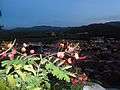 View from Saint Rita Mountain
 Acarape do Meio Lake
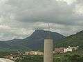 Auroras Campus of UNILAB
 Road in Redenção
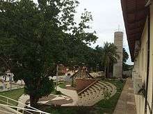 Liberdade Campus of UNILAB
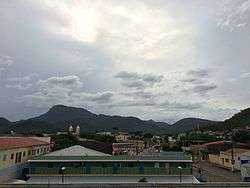
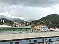 Redenção from above
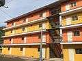 Residential Building
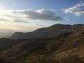 Nature around the city
See also
- List of municipalities in Ceará
- Universidade da Integração Internacional da Lusofonia Afro-Brasileira (UNILAB)
- Fortaleza
References
- ↑ "Divisão Territorial do Brasil" (in Portuguese). Divisão Territorial do Brasil e Limites Territoriais, Instituto Brasileiro de Geografia e Estatística (IBGE). July 1, 2008. Retrieved December 17, 2009.
- ↑ "Estimativas da população para 1º de julho de 2009" (PDF) (in Portuguese). Estimativas de População, Instituto Brasileiro de Geografia e Estatística (IBGE). August 14, 2009. Retrieved December 17, 2009.
- ↑ "Ranking decrescente do IDH-M dos municípios do Brasil" (in Portuguese). Atlas do Desenvolvimento Humano, Programa das Nações Unidas para o Desenvolvimento (PNUD). 2000. Retrieved December 17, 2009.
- ↑ "Produto Interno Bruto dos Municípios 2002-2005" (PDF) (in Portuguese). Instituto Brasileiro de Geografia e Estatística (IBGE). December 19, 2007. Retrieved December 17, 2009.
- ↑ http://www.unilab.edu.br/wp-content/uploads/2013/01/História-de-Redencão.pdf
- ↑ http://www7.cptec.inpe.br/cidades/previsao.do?parameter=tempo&id=4290
- ↑ http://www.unilab.edu.br/campus-da-liberdade/
Capital: Fortaleza | |||||||||||||||||||||||||||||||||||||
|  | ||||||||||||||||||||||||||||||||||||
|
| |||||||||||||||||||||||||||||||||||||
| |||||||||||||||||||||||||||||||||||||
| |||||||||||||||||||||||||||||||||||||
| |||||||||||||||||||||||||||||||||||||
| |||||||||||||||||||||||||||||||||||||
Coordinates: 4°13′33″S 38°43′51″W / 4.22583°S 38.73083°W