Ridgeville, Indiana
| Ridgeville, Indiana | |
|---|---|
| Town | |
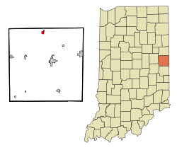 Location of Ridgeville in the state of Indiana | |
| Coordinates: 40°17′27″N 85°1′45″W / 40.29083°N 85.02917°WCoordinates: 40°17′27″N 85°1′45″W / 40.29083°N 85.02917°W | |
| Country | United States |
| State | Indiana |
| County | Randolph |
| Township | Franklin |
| Area[1] | |
| • Total | 0.56 sq mi (1.45 km2) |
| • Land | 0.56 sq mi (1.45 km2) |
| • Water | 0 sq mi (0 km2) |
| Elevation | 997 ft (304 m) |
| Population (2010)[2] | |
| • Total | 803 |
| • Estimate (2012[3]) | 792 |
| • Density | 1,433.9/sq mi (553.6/km2) |
| Time zone | Eastern (EST) (UTC-5) |
| • Summer (DST) | EDT (UTC-4) |
| ZIP code | 47380 |
| Area code(s) | 765 |
| FIPS code | 18-64422[4] |
| GNIS feature ID | 0442000[5] |
Ridgeville is a town in Franklin Township, Randolph County, Indiana, United States, along the Mississinewa River. The population was 803 at the 2010 census.
History
A post office called Ridgeville has been in operation since 1851.[6] The town was named for its lofty elevation.[7]
Geography
Ridgeville is located at 40°17′27″N 85°1′45″W / 40.29083°N 85.02917°W (40.290723, -85.029183).[8]
According to the 2010 census, Ridgeville has a total area of 0.55 square miles (1.42 km2), all land.[1]
Demographics
| Historical population | |||
|---|---|---|---|
| Census | Pop. | %± | |
| 1870 | 716 | — | |
| 1880 | 775 | 8.2% | |
| 1890 | 922 | 19.0% | |
| 1910 | 440 | — | |
| 1920 | 1,042 | 136.8% | |
| 1930 | 909 | −12.8% | |
| 1940 | 1,003 | 10.3% | |
| 1950 | 950 | −5.3% | |
| 1960 | 950 | 0.0% | |
| 1970 | 924 | −2.7% | |
| 1980 | 933 | 1.0% | |
| 1990 | 808 | −13.4% | |
| 2000 | 843 | 4.3% | |
| 2010 | 803 | −4.7% | |
| Est. 2015 | 769 | [9] | −4.2% |
2010 census
As of the census[2] of 2010, there were 803 people, 323 households, and 219 families residing in the town. The population density was 1,433.9 inhabitants per square mile (553.6/km2). There were 371 housing units at an average density of 662.5 per square mile (255.8/km2). The racial makeup of the town was 97.4% White, 0.4% Native American, 0.4% Asian, 0.2% from other races, and 1.6% from two or more races. Hispanic or Latino of any race were 0.6% of the population.
There were 323 households of which 35.6% had children under the age of 18 living with them, 46.7% were married couples living together, 15.8% had a female householder with no husband present, 5.3% had a male householder with no wife present, and 32.2% were non-families. 28.2% of all households were made up of individuals and 12.1% had someone living alone who was 65 years of age or older. The average household size was 2.49 and the average family size was 3.01.
The median age in the town was 35.1 years. 28.1% of residents were under the age of 18; 8.5% were between the ages of 18 and 24; 26.2% were from 25 to 44; 22.9% were from 45 to 64; and 14.3% were 65 years of age or older. The gender makeup of the town was 50.8% male and 49.2% female.
2000 census
As of the census[4] of 2000, there were 843 people, 340 households, and 234 families residing in the town. The population density was 1,429.4 people per square mile (551.7/km²). There are 368 housing units at an average density of 624.0 per square mile (240.8/km²). The racial makeup of the town was 99.76% White, 0.12% Native American, and 0.12% from two or more races. Hispanic or Latino of any race were 0.24% of the population.
There were 340 households out of which 32.4% had children under the age of 18 living with them, 52.9% were married couples living together, 10.9% had a female householder with no husband present, and 30.9% were non-families. 25.9% of all households were made up of individuals and 11.5% had someone living alone who was 65 years of age or older. The average household size was 2.48 and the average family size was 2.97.
In the town the population was spread out with 26.1% under the age of 18, 10.6% from 18 to 24, 27.9% from 25 to 44, 23.0% from 45 to 64, and 12.5% who were 65 years of age or older. The median age was 34 years. For every 100 females there were 99.8 males. For every 100 females age 18 and over, there were 97.8 males.
The median income for a household in the town was $33,819, and the median income for a family was $40,547. Males had a median income of $27,596 compared to $24,107 for females. The per capita income for the town was $14,547. About 7.4% of families and 8.3% of the population were below the poverty line, including 7.9% of those under the age of 18 and 9.2% of those 65 and older.
Notable person
- Wendell Meredith Stanley (1904–1971), co-recipient of the 1946 Nobel Prize in Chemistry, was born in Ridgeville.
References
- 1 2 "G001 - Geographic Identifiers - 2010 Census Summary File 1". United States Census Bureau. Retrieved 2015-07-20.
- 1 2 "American FactFinder". United States Census Bureau. Retrieved 2012-12-11.
- ↑ "Population Estimates". United States Census Bureau. Archived from the original on June 17, 2013. Retrieved 2013-06-25.
- 1 2 "American FactFinder". United States Census Bureau. Archived from the original on September 11, 2013. Retrieved 2008-01-31.
- ↑ "US Board on Geographic Names". United States Geological Survey. 2007-10-25. Retrieved 2008-01-31.
- ↑ "Randolph County". Jim Forte Postal History. Retrieved 1 November 2015.
- ↑ Baker, Ronald L. (October 1995). From Needmore to Prosperity: Hoosier Place Names in Folklore and History. Indiana University Press. p. 280. ISBN 978-0-253-32866-3.
...slightly elevated land of the townsite...
- ↑ "US Gazetteer files: 2010, 2000, and 1990". United States Census Bureau. 2011-02-12. Retrieved 2011-04-23.
- ↑ "Annual Estimates of the Resident Population for Incorporated Places: April 1, 2010 to July 1, 2015". Retrieved July 2, 2016.
- ↑ "Census of Population and Housing". Census.gov. Archived from the original on May 11, 2015. Retrieved June 4, 2015.
Municipalities and communities of Randolph County, Indiana, United States | ||
|---|---|---|
| Cities | ||
| Towns | ||
| Townships | ||
| Unincorporated communities |
| |
| Footnotes | ‡This populated place also has portions in an adjacent county or counties | |