Rincón de Romos
| Rincón de Romos | |
|---|---|
| City | |
 Municipality location in Aguascalientes | |
|
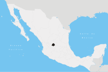
Rincón de Romos Location in Mexico | |
| Coordinates: 22°14′N 102°19′W / 22.233°N 102.317°WCoordinates: 22°14′N 102°19′W / 22.233°N 102.317°W | |
| Country |
|
| State | Aguascalientes |
| Municipality | Rincón de Romos |
| Population (2010) | |
| • Total | 27,988 |
Rincón de Romos is a city in the Mexican state of Aguascalientes. Located at 22°14′N 102°19′W / 22.233°N 102.317°W in the northern part of the state, it serves as the municipal seat of the surrounding municipality of Rincón de Romos.
As of 2010, the city had a total population of 27,988.[1]
Most of the inhabitants of Rincón de Romos are Catholic. Rincón de Romos celebrates a "Fiesta" to the Señor de las Angustias on January with dances and pyrotechnic games. There is a church to him downtown. Most of the locals work as teachers. The city was once home to a priest named Padre Nieves who people believed made miracles. He has a church in the city, and many people go to Rincón de Romos to pray for miracles. Rincón de Romos has the biggest rural hospital ruled by the government of Aguascalientes.
Rincón de Romos is a town located in the central-northern region of Aguascalientes, Mexico. In 1639, the Real Audiencia of Guadalajara authorized the creation of a little town, which became known throughout time as Chora. In 1658, Captain Diego Romo de Vivar y Pérez, a member of a noble family belonging to the illustrious House of Vivar, bought the majority of the land of Hacienda de Rincón from Don Pedro Rincon of Arteaga. Consequently, this business deal combined both names and changed the town name of Chora to Rincón de Romos. Its coordinates are 102°19’ E longitude, and 22°14’ N latitude, with an altitude of 1,940 meters above sea level.
Rincón de Romos borders the municipality of Cosío on the north, Pabellón de Arteaga to the south, Tepezalá on the east and San Jose de Gracia on the west. It is divided into 64 towns, of which the most important are the municipal capitals: Rincón de Romos, the town of Pabellón de Hidalgo, Pablo Escaleras, San Jacinto and El Bajio. It makes up a surface area of 372.93 square meters, representing 6.7% of the state’s territory. Rincón de Romos is part of the province of the Sierra Madre Occidental. In the province of the Mesa Central are semi-flat zones in the center and northeastern parts of the city, as well as flat areas in the center and northeast between the Fria and Loreto mountains.
Climate
Rincón de Romos has a dry climate, with an average temperature of 18° Celsius in the hottest months of May and August. Its annual precipitation is approximately 400 millimeters. The wind generally moves from north to southeast in the summer and part of fall.
| Climate data for Rincón de Romos (1951–2010) | |||||||||||||
|---|---|---|---|---|---|---|---|---|---|---|---|---|---|
| Month | Jan | Feb | Mar | Apr | May | Jun | Jul | Aug | Sep | Oct | Nov | Dec | Year |
| Record high °C (°F) | 28.0 (82.4) |
32.0 (89.6) |
35.0 (95) |
37.0 (98.6) |
38.0 (100.4) |
38.0 (100.4) |
36.0 (96.8) |
34.0 (93.2) |
36.0 (96.8) |
32.0 (89.6) |
31.0 (87.8) |
28.0 (82.4) |
38.0 (100.4) |
| Average high °C (°F) | 20.7 (69.3) |
22.8 (73) |
25.7 (78.3) |
28.6 (83.5) |
30.0 (86) |
29.2 (84.6) |
26.3 (79.3) |
26.0 (78.8) |
24.9 (76.8) |
24.5 (76.1) |
23.1 (73.6) |
21.2 (70.2) |
25.3 (77.5) |
| Daily mean °C (°F) | 11.5 (52.7) |
13.0 (55.4) |
15.6 (60.1) |
18.1 (64.6) |
20.0 (68) |
20.0 (68) |
18.5 (65.3) |
18.1 (64.6) |
17.3 (63.1) |
15.7 (60.3) |
13.5 (56.3) |
11.9 (53.4) |
16.1 (61) |
| Average low °C (°F) | 2.2 (36) |
3.3 (37.9) |
5.5 (41.9) |
7.7 (45.9) |
9.9 (49.8) |
10.8 (51.4) |
10.7 (51.3) |
10.3 (50.5) |
9.7 (49.5) |
6.9 (44.4) |
4.0 (39.2) |
2.6 (36.7) |
7.0 (44.6) |
| Record low °C (°F) | −8.0 (17.6) |
−5.0 (23) |
−2.0 (28.4) |
0.0 (32) |
3.0 (37.4) |
4.0 (39.2) |
5.0 (41) |
5.0 (41) |
0.0 (32) |
−4.0 (24.8) |
−6.0 (21.2) |
−13.0 (8.6) |
−13.0 (8.6) |
| Average precipitation mm (inches) | 19.6 (0.772) |
10.5 (0.413) |
2.4 (0.094) |
6.4 (0.252) |
18.7 (0.736) |
53.0 (2.087) |
98.0 (3.858) |
78.5 (3.091) |
64.0 (2.52) |
34.6 (1.362) |
7.2 (0.283) |
10.1 (0.398) |
403.0 (15.866) |
| Average precipitation days (≥ 0.1 mm) | 2.2 | 1.4 | 0.6 | 1.1 | 3.5 | 6.8 | 10.5 | 9.4 | 8.0 | 3.5 | 1.1 | 1.9 | 50.0 |
| Source: Servicio Meteorologico Nacional[2][3] | |||||||||||||
Population
According to the census of 2010 done by the National Statistics and Geography Institute (INEGI), the city has a population of 79,240. The total population represents 8.41% of the state’s population. It is worth noting that the city of Rincón de Romos is considered as the most important after the state capitol of Aguascalientes. Aguascalientes is second most important in terms of population, organization, and innovation in the state. The mixed-race population is diminishing, as well as the indigenous and North American populations of the region.
Religion
In 2000, according to the census done by Inegi, the population of Catholics 5 years and older rose to 76,789, while the non-Catholics in the same age range totaled 5,079 people.
Economy
The Panamerican Highway plays an important role in trade. There are also mercury mines and copper, which are exploding industries.
Agriculture
Thanks to irrigation, agriculture is big. Corn, Beans, Garlic, Potatoes, Chile, as well as peaches, pears and grapes are grown.
Services
Rincón de Romos has medical services, gas stations, restaurants, tourist centers, a train station, a bus station, a repair shop, taxis, telephone, mail, and auto services, as well as shopping. It also has its own university and high school.
References
- ↑ "Rincón de Romos". Catálogo de Localidades. Secretaría de Desarrollo Social (SEDESOL). Retrieved 23 April 2014.
- ↑ "Estado de Aguascalientes-Estacion: Rincón de Romos". Normales Climatologicas 1951–2010 (in Spanish). Servicio Meteorologico Nacional. Retrieved 8 May 2015.
- ↑ "Extreme Temperatures and Precipitation for Rincón de Romos 1979–2010" (in Spanish). Servicio Meteorológico Nacional. Retrieved 8 May 2015.
- Link to tables of population data from Census of 2005 Instituto Nacional de Estadística, Geografía e Informática (INEGI)
- Aguascalientes Enciclopedia de los Municipios de México
External links
- Gobierno de Rincón de Romos Official website
- http://www.aguascalientes.gob.mx/ Gobierno del Estado de Aguascalientes] Official website of State of Aguascalientes