Rincón de Romos Municipality
| Rincón de Romos | ||
|---|---|---|
| Municipality | ||
| ||
 Municipality location in Aguascalientes | ||
|
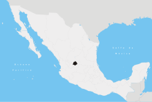
Rincón de Romos Location in Mexico | ||
| Coordinates: 22°14′N 102°19′W / 22.233°N 102.317°WCoordinates: 22°14′N 102°19′W / 22.233°N 102.317°W | ||
| Country |
| |
| State | Aguascalientes | |
| Municipal seat | Rincón de Romos | |
| Area | ||
| • Total | 376.77 km2 (145.47 sq mi) | |
| Population (2015) | ||
| • Total | 53,866 | |
| • Density | 140/km2 (370/sq mi) | |

Rincón de Romos is a municipality in the Mexican state of Aguascalientes. It is located at 22°14′N 102°19′W / 22.233°N 102.317°W in the northern part of the state. The municipal seat is the city of Rincón de Romos (2010 census population of 27,988 inhabitants)
The municipality has an area of 376.77 km².
Demographics
As of 2010, the municipality had a total population of 49,156.[1]
As of 2010, the city of Rincón de Romos had a population of 27,988.[1] Other than the city of Rincón de Romos, the municipality had 355 localities, the largest of which (with 2010 populations in parentheses) were: Pabellón de Hidalgo (4,316), Escaleras (2,790), classified as urban, and San Jacinto (2,356), and El Bajío (1,278), classified as rural.[1]
References
- 1 2 3 "Rincón de Romos". Catálogo de Localidades. Secretaría de Desarrollo Social (SEDESOL). Retrieved 23 April 2014.
- Link to tables of population data from Census of 2005 INEGI: Instituto Nacional de Estadística, Geografía e Informática
- Aguascalientes Enciclopedia de los Municipios de México
External links
- Gobierno de Rincón de Romos Official website
- http://www.aguascalientes.gob.mx/ Gobierno del Estado de Aguascalientes] Official website of State of Aguascalientes
This article is issued from Wikipedia - version of the 12/22/2015. The text is available under the Creative Commons Attribution/Share Alike but additional terms may apply for the media files.