Roaring River Township, Barry County, Missouri
| Roaring River Township | |
|---|---|
| Township | |
 | |
| Coordinates: 36°32′45″N 093°43′49″W / 36.54583°N 93.73028°WCoordinates: 36°32′45″N 093°43′49″W / 36.54583°N 93.73028°W | |
| Country | United States |
| State | Missouri |
| County | Barry |
| Area | |
| • Total | 72.06 sq mi (186.63 km2) |
| • Land | 68.68 sq mi (177.87 km2) |
| • Water | 3.38 sq mi (8.76 km2) 4.69% |
| Elevation[1] | 968 ft (295 m) |
| Population (2000) | |
| • Total | 1,396 |
| • Density | 20.3/sq mi (7.8/km2) |
| FIPS code | 29-62318[2] |
| GNIS feature ID | 0766268 |
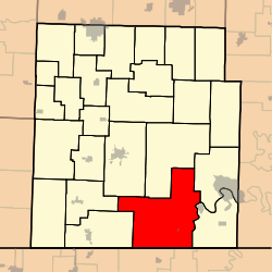
Roaring River Township is one of twenty-five townships in Barry County, Missouri, United States. As of the 2000 census, its population was 1,396.
The township takes its name from Roaring River.[3]
Geography
Roaring River Township covers an area of 72.06 square miles (186.6 km2) and contains one incorporated settlement, Chain-O-Lakes. It contains three cemeteries: Easley, Munsey and Roach.
The streams of Butler Creek, Cedar Creek, Darity Branch, East Fork Rock Creek, Haddock Creek, Hottle Branch, Johns Branch, Panther Creek, Raridan Branch, Roaring River and Stubblefield Branch run through this township.
References
- ↑ "US Board on Geographic Names". United States Geological Survey. 2007-10-25. Retrieved 2008-01-31.
- ↑ "American FactFinder". United States Census Bureau. Retrieved 2008-01-31.
- ↑ "Barry County Place Names, 1928-1945 (archived)". The State Historical Society of Missouri. Retrieved 30 August 2016.
External links
Municipalities and communities of Barry County, Missouri, United States | ||
|---|---|---|
| Cities | 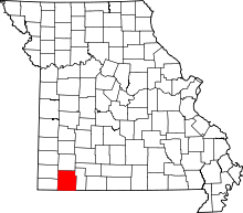 | |
| Villages | ||
| Townships | ||
| CDPs | ||
| Unincorporated communities | ||
| Ghost towns | ||
| Footnotes | ‡This populated place also has portions in an adjacent county or counties | |
This article is issued from Wikipedia - version of the 9/3/2016. The text is available under the Creative Commons Attribution/Share Alike but additional terms may apply for the media files.