Rockfield, Indiana
| Rockfield | |
|---|---|
| Unincorporated community | |
 Carroll County's location in Indiana | |
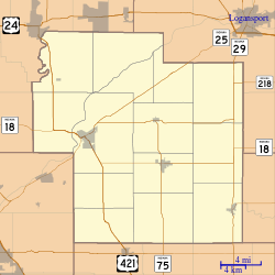 Rockfield Location in Carroll County | |
| Coordinates: 40°38′28″N 86°34′26″W / 40.64111°N 86.57389°WCoordinates: 40°38′28″N 86°34′26″W / 40.64111°N 86.57389°W | |
| Country | United States |
| State | Indiana |
| County | Carroll |
| Township | Rock Creek |
| Elevation[1] | 699 ft (213 m) |
| ZIP code | 46923 |
| GNIS feature ID | 442217 |
Rockfield is an unincorporated community in Rock Creek Township, Carroll County, Indiana. It is part of the Lafayette, Indiana Metropolitan Statistical Area.
History
Rockfield was platted in 1856.[2] The Rockfield post office was established in 1857.[3] District School No. 3 was listed on the National Register of Historic Places in 1988.[4]
Geography
Rockfield is located at 40°38′28″N 86°34′26″W / 40.64111°N 86.57389°W in open farm land south of Rock Creek. Indiana State Road 25 and the Norfolk Southern Railway both pass northeast through town.
References
- ↑ "US Board on Geographic Names". United States Geological Survey. 2007-10-25. Retrieved 2008-01-31.
- ↑ Baker, Ronald L. (October 1995). From Needmore to Prosperity: Hoosier Place Names in Folklore and History. Indiana University Press. p. 283. ISBN 978-0-253-32866-3.
This village, platted on August 11, 1856...
- ↑ "Carroll County". Jim Forte Postal History. Retrieved 28 August 2014.
- ↑ National Park Service (2010-07-09). "National Register Information System". National Register of Historic Places. National Park Service.
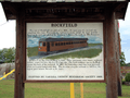 Historical marker at the intersection of Walnut and Lake depicting an Interurban streetcar.
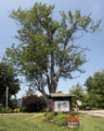 Memorial to a World War I soldier at the corner of Erie Street and Rockfield Road.
Municipalities and communities of Carroll County, Indiana, United States | ||
|---|---|---|
| City | ||
| Towns | ||
| Townships | ||
| Unincorporated communities |
| |
This article is issued from Wikipedia - version of the 10/26/2016. The text is available under the Creative Commons Attribution/Share Alike but additional terms may apply for the media files.