Rosedale, Virginia
| Rosedale, Virginia | |
|---|---|
| Unincorporated community | |
 Rosedale, Virginia  Rosedale, Virginia | |
| Coordinates: 36°57′33″N 81°55′52″W / 36.95917°N 81.93111°WCoordinates: 36°57′33″N 81°55′52″W / 36.95917°N 81.93111°W | |
| Country | United States |
| State | Virginia |
| County | Russell |
| Elevation | 2,267 ft (691 m) |
| Time zone | Eastern (EST) (UTC-5) |
| • Summer (DST) | EDT (UTC-4) |
| ZIP code | 24280 |
| Area code(s) | 276 |
| GNIS feature ID | 1494263[1] |
Rosedale is an unincorporated community in Russell County, Virginia, United States. Rosedale is located at the junction of U.S. Route 19 and Virginia State Route 80 4.6 miles (7.4 km) south-southeast of Honaker. The community was founded in 1819.[1] Rosedale hads a post office with ZIP code 24280, which opened on February 26, 1897.[2][3] Rosedale was named for the area's Rosedale Plantation; the plantation was either named after the couple that owned the property or named for a "rose valley". The community has also been known as Elway and Oaks Garage, the latter name coming from a service station in the settlement.[4]
Smithfield was listed on the National Register of Historic Places in 1994.[5]
References
- 1 2 "Rosedale". Geographic Names Information System. United States Geological Survey.
- ↑ United States Postal Service (2012). "USPS - Look Up a ZIP Code". Retrieved 2012-02-15.
- ↑ "Postmaster Finder - Post Offices by ZIP Code". United States Postal Service. Retrieved December 22, 2012.
- ↑ Tennis, Joe (2004). Southwest Virginia Crossroads: An Almanac of Place Names And Places to See. The Overmountain Press. p. 166. ISBN 9781570722561.
- ↑ National Park Service (2010-07-09). "National Register Information System". National Register of Historic Places. National Park Service.
Municipalities and communities of Russell County, Virginia, United States | ||
|---|---|---|
| Towns | 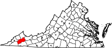 | |
| CDPs | ||
| Unincorporated community | ||
| Footnotes | ‡This populated place also has portions in an adjacent county or counties | |
This article is issued from Wikipedia - version of the 7/27/2016. The text is available under the Creative Commons Attribution/Share Alike but additional terms may apply for the media files.