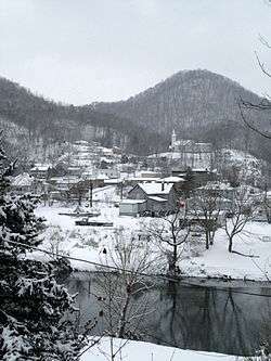
Cleveland, Virginia
| Cleveland, Virginia | |
|---|---|
| Town | |
 | |
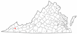 Location of Cleveland, Virginia | |
| Coordinates: 36°56′37″N 82°9′8″W / 36.94361°N 82.15222°WCoordinates: 36°56′37″N 82°9′8″W / 36.94361°N 82.15222°W | |
| Country | United States |
| State | Virginia |
| County | Russell |
| Government | |
| • Type | City |
| Area | |
| • Total | 0.1 sq mi (0.4 km2) |
| • Land | 0.1 sq mi (0.3 km2) |
| • Water | 0.0 sq mi (0.0 km2) |
| Elevation | 1,526 ft (465 m) |
| Population (2000) | |
| • Total | 148 |
| • Density | 1,251.7/sq mi (483.3/km2) |
| Time zone | Eastern (EST) (UTC-5) |
| • Summer (DST) | EDT (UTC-4) |
| ZIP code | 24225 |
| Area code(s) | 276 |
| FIPS code | 51-17296[1] |
| GNIS feature ID | 1464978[2] |
Cleveland is a town in Russell County, Virginia. The population was 128 at the 2010 census.
History
Jessees Mill was listed on the National Register of Historic Places in 2005.[3]
Geography
Cleveland is located at 36°56′37″N 82°9′8″W / 36.94361°N 82.15222°W (36.943674, -82.152334).[4]
According to the United States Census Bureau, the town has a total area of 0.1 square mile (0.4 km²), of which 0.1 square mile (0.3 km²) is land and 0.04 square mile (0.1 km²) (14.29%) is water.
Demographics
| Historical population | |||
|---|---|---|---|
| Census | Pop. | %± | |
| 1910 | 252 | — | |
| 1950 | 388 | — | |
| 1960 | 415 | 7.0% | |
| 1970 | 357 | −14.0% | |
| 1980 | 360 | 0.8% | |
| 1990 | 214 | −40.6% | |
| 2000 | 148 | −30.8% | |
| 2010 | 202 | 36.5% | |
| Est. 2015 | 187 | [5] | −7.4% |
As of the census[1] of 2000, there were 148 people, 81 households, and 43 families residing in the town. As of 2010 the population has declined to 128. The population density was 1,251.7 people per square mile (476.2/km²). There were 113 housing units at an average density of 955.7 per square mile (363.6/km²). The racial makeup of the town was 97.97% White, and 2.03% from two or more races.
There were 81 households out of which 11.1% had children under the age of 18 living with them, 43.2% were married couples living together, 6.2% had a female householder with no husband present, and 45.7% were non-families. 42.0% of all households were made up of individuals and 19.8% had someone living alone who was 65 years of age or older. The average household size was 1.83 and the average family size was 2.45.
In the town the population was spread out with 8.8% under the age of 18, 6.8% from 18 to 24, 23.0% from 25 to 44, 28.4% from 45 to 64, and 33.1% who were 65 years of age or older. The median age was 55 years. For every 100 females there were 102.7 males. For every 100 females age 18 and over, there were 104.5 males.
The median income for a household in the town was $11,346, and the median income for a family was $14,688. Males had a median income of $35,833 versus $25,000 for females. The per capita income for the town was $11,263. There were 36.6% of families and 41.8% of the population living below the poverty line, including 61.5% of under eighteens and 33.3% of those over 64.
References
- 1 2 "American FactFinder". United States Census Bureau. Retrieved 2008-01-31.
- ↑ "US Board on Geographic Names". United States Geological Survey. 2007-10-25. Retrieved 2008-01-31.
- ↑ National Park Service (2010-07-09). "National Register Information System". National Register of Historic Places. National Park Service.
- ↑ "US Gazetteer files: 2010, 2000, and 1990". United States Census Bureau. 2011-02-12. Retrieved 2011-04-23.
- ↑ "Annual Estimates of the Resident Population for Incorporated Places: April 1, 2010 to July 1, 2015". Retrieved July 2, 2016.
- ↑ "Census of Population and Housing". Census.gov. Archived from the original on May 11, 2015. Retrieved June 4, 2015.
Municipalities and communities of Russell County, Virginia, United States | ||
|---|---|---|
| Towns | 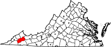 | |
| CDPs | ||
| Unincorporated community | ||
| Footnotes | ‡This populated place also has portions in an adjacent county or counties | |