Rowland's Castle
| Rowland's Castle | |
 Rowland's Castle Green |
|
 Rowland's Castle |
|
| Population | 2,770 [1] |
|---|---|
| OS grid reference | SU733106 |
| Civil parish | Rowland's Castle |
| District | East Hampshire |
| Shire county | Hampshire |
| Region | South East |
| Country | England |
| Sovereign state | United Kingdom |
| Post town | ROWLAND'S CASTLE |
| Postcode district | PO9 6 |
| Dialling code | 023 |
| Police | Hampshire |
| Fire | Hampshire |
| Ambulance | South Central |
| EU Parliament | South East England |
| UK Parliament | Meon Valley |
Coordinates: 50°53′28″N 0°57′36″W / 50.89115°N 0.96006°W
Rowland's Castle (or Rowlands Castle; the apostrophe is disputed) is a village and civil parish in the East Hampshire district of Hampshire, England. It is 2.9 miles (4.7 km) north of Havant, on the Hampshire/West Sussex border.
The village lies in the area of the former Forest of Bere on the eastern boundary of Hampshire. To the east in the parish of Stoughton, West Sussex is Stansted Park. Former British tennis player Chris Wilkinson is a notable figure living in Rowland's Castle.
The village
It is largely a quiet residential village, with four pubs and a few small shops, including a hardware store, which appeared in an episode of the 2010 series of The Apprentice, and local convenience store. The village takes its name from a Motte-and-bailey castle, the remains of which are situated to the south of Redhill Road and west of the railway line, east of the current centre of the village.
Lionel 'Buster' Crabb, a famous Royal Navy diver, post World War II, lived in Whichers Gate Road and was a local at the Staunton Arms Pub at the entrance of the village, where he was remembered by local villagers.
Former Van Morrison guitarist Herbie Armstrong once operated The Fountain Inn in the centre of the village next to the Village Green. His weekly live music evenings attracted music lovers from across the region, and have been known to include some famous faces; Mick Hucknall on one occasion.
In 1994 Stage 5 of the Tour de France passed through Rowland's Castle, attracting large crowds during one of the busiest days in the village's history.
Transport links
Rowland's Castle is served by a railway station on the Portsmouth Direct Line between London Waterloo and Portsmouth. It is only manned early on weekday mornings. There is just one bus route. It is route 27 which is operated by Emsworth and District.
The village is crossed by three long-distance footpaths, the Monarch's Way, Sussex Border Path and Staunton Way.
History
The Romans made pottery, brick and tiles at Rowland's Castle because suitable clay was available. The castle was built at some time between 1066 and 1199 and is first documented under the name ROLOKECASTEL in 1381.[2] It was in good repair in the twelfth century, when Henry II spent several days there in hunting and amusement,[3] but was abandoned by the 15th century. The site was damaged by the railway and quarrying in the 19th century and now only the earthworks and a few small areas of wall remain.
Local architecture
St. Huberts chapel
St. Huberts chapel[4] is located on the outskirts of Rowlands Castle at Idsworth.[5] St. Huberts chapel was built in 1053 and was originally dedicated to St. Peter and St. Paul. It is a Grade I listed building, listed on 16 March 1954[6] The chapel contains examples of medieval paintings from around 1300 which include paintings around the altar window of St. Peter, St. Paul, and two angels. On the north wall there is a painting of St. Hubert and St. John the Baptist. The narthex contains an octagonal stone font and above it is a gallery which contains the church organ.
Geology
Rowland's Castle lies on the northern edge of the Neogene deposits of the Hampshire Basin. The north of the village lies on the chalk of the southern South Downs. In the south is the Reading Formation which gave rise to the former local brick industry.[7]
Gallery
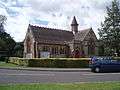 The Church on the Green
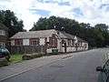 Parish Hall
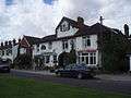 The Fountain (live music venue)
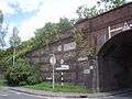 Bowes Hill Junction
References
- ↑ "Parish Headcounts, Area: Rowland's Castle CP". Neighbourhood Statistics. Office for National Statistics. 2001. Retrieved 2008-04-03.
- ↑ Hanks, P. Hodges F., Mills, A.D. & Room A. (2002), The Oxford Names Companion, Oxford: Oxford University Press, ISBN 0-19-860561-7
- ↑ "Rowlands Castle". Hampshire County Council. Retrieved 2007-07-01.
- ↑ 50°55′17″N 0°56′41″W / 50.92139°N 0.94472°W (OSGB36 Grid ref: SU 7427914070)
- ↑ Nearby.Org Co-ordinate converter, coordinate location
- ↑ British Listed Buildings, St. Huberts Chapel.
- ↑ British Geological Survey (1998), England and Wales Sheet 316 Fareham, 1:50,000 series geological map, Keyworth, Nottingham: British Geological Survey, ISBN 0-7518-3168-9
External links
| Wikimedia Commons has media related to Rowland's Castle. |
- http://www.rowlandscastle.com - Rowlands Castle Village website and discussion forum
- Stained Glass Windows at St. John, Rowlands Castle, Hampshire
